
43°00′N 113°30′W / 43.000°N 113.500°W / 43.000; -113.500 The Snake River Plain is a geologic feature located primarily within the U.S. state of Idaho...
10 KB (906 words) - 03:16, 15 October 2023
millions of years ago, Columbia River basalts covered vast areas of the western Snake River watershed, while the Snake River Plain was a product of the Yellowstone...
153 KB (16,133 words) - 00:48, 6 September 2024

Yellowstone hotspot (redirect from Snake River Plain-Yellowstone Hotspot)
North American tectonic plate moved over it. It formed the eastern Snake River Plain through a succession of caldera-forming eruptions. The resulting calderas...
40 KB (4,303 words) - 08:18, 6 May 2024

The Snake River Plain ecoregion is a Level III ecoregion designated by the United States Environmental Protection Agency (EPA) in the U.S. states of Idaho...
17 KB (1,982 words) - 04:05, 1 September 2024

Mississippi Alluvial Plain (Mississippi) Oxnard Plain (Ventura County, California) Snake River Plain (Idaho) Chianan Plain (Taiwan) Depsang Plains (China and India)...
17 KB (1,639 words) - 20:57, 10 April 2024

The paleo-climate of the Snake River Plain in southern Idaho, U.S., was much wetter and milder than today’s climate. During the Pliocene, the presence...
12 KB (1,586 words) - 21:08, 20 July 2024

Henrys Fork is a tributary river of the Snake River, approximately 127 miles (204 km) long, in southeastern Idaho in the United States. It is also referred...
10 KB (851 words) - 19:13, 13 August 2024
The Snake River Aquifer is a large reservoir of groundwater underlying the Snake River Plain in the southern part of the U.S. state of Idaho. Most of the...
3 KB (398 words) - 21:07, 23 June 2023

southwestern Idaho northeast of Boise, as well as part of the western Snake River Plain. The watershed encompasses approximately 4,100 square miles (11,000 km2)...
14 KB (1,253 words) - 14:05, 13 January 2024

cold deserts lie within the Columbia Plateau/Columbia Basin, the Snake River Plain, and the Colorado Plateau regions. (listed from north to south) Great...
10 KB (869 words) - 23:54, 5 October 2023
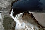
the dam was not rebuilt. Interest in building a dam in the eastern Snake River Plain had arisen for many years to control spring runoff and provide a more...
28 KB (3,290 words) - 02:51, 4 August 2024

Preserve is a U.S. national monument and national preserve in the Snake River Plain in central Idaho. It is along US 20 (concurrent with US 93 and US...
70 KB (7,557 words) - 18:22, 24 August 2024

lava plain located on the Snake River Plain of Idaho in the United States. It is the easternmost of the basaltic lava fields on the Snake River Plain, located...
16 KB (1,974 words) - 06:42, 27 July 2024

Idaho (redirect from List of lakes and rivers of Idaho)
state uses the Mountain Time Zone. The state's south includes the Snake River Plain (which has most of the population and agricultural land), and the...
105 KB (8,375 words) - 20:02, 4 September 2024

Geology of the United States (section Interior Plains)
River region, volcanic eruptions dominate the story of the Snake River Plain in the eastern part of the Columbia Plateau Province. The earliest Snake...
51 KB (6,773 words) - 11:10, 22 August 2024
of the Snake River Plain. The city of Pocatello sits along the river near its emergence from the mountains onto the Snake River Plain. The river is part...
17 KB (1,850 words) - 14:12, 11 February 2024
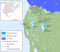
caldera lies the Snake River Plain, which was formed by a succession of older calderas marking the path of the Yellowstone hotspot. The plain is a depression...
4 KB (387 words) - 05:02, 25 August 2024
Bonneville flood (category Snake River)
approximately 33,000,000 cubic feet per second (930,000 m3/s) poured over the Snake River Plain at speeds of up to 70 miles per hour (110 km/h) and deposited hundreds...
8 KB (913 words) - 09:41, 28 March 2024

the Snake River Plain located in the area. The northern Magic Valley region — particularly Blaine and Camas Counties — is also known as the Wood River Valley...
11 KB (686 words) - 16:07, 30 March 2024

the northeast corner of California. It also connects east onto the Snake River Plain, which it follows east from Hells Canyon to the continental divide...
3 KB (185 words) - 04:13, 18 June 2024

Northern Shoshone are Shoshone of the Snake River Plain of southern Idaho and the northeast of the Great Basin where Idaho, Wyoming and Utah meet. They...
12 KB (1,416 words) - 18:48, 6 May 2023
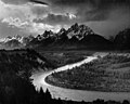
its journey north. Yellowstone is at the northeastern end of the Snake River Plain, a great bow-shaped arc through the mountains that extends roughly...
163 KB (15,754 words) - 22:50, 1 September 2024

River region, volcanic eruptions dominate the story of the Snake River Plain in the eastern part of the Columbia Plateau Province. The earliest Snake...
36 KB (4,678 words) - 08:58, 14 July 2024

Yellowstone Caldera (category Snake River)
east-northeast direction, and is responsible for the eastern half of Idaho's Snake River Plain, but in fact the hotspot is much deeper than the surrounding terrain...
38 KB (3,875 words) - 20:24, 16 August 2024

Basin are Native Americans of the northern Great Basin, Snake River Plain, and upper Colorado River basin. The "Great Basin" is a cultural classification...
14 KB (1,373 words) - 08:06, 1 May 2024
end of the Snake River Plain. Its location along the western flank of the Tetons provides the river with more rainfall than many other rivers of the region...
11 KB (1,100 words) - 11:01, 16 July 2021
Geology of Idaho (section Snake River Plain)
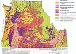
The Geology of Idaho is complex, with outcroppings of differing ages of volcanics, undifferentiated metamorphics and sedimentary structures. Since 1919...
4 KB (292 words) - 08:56, 14 July 2024

domes formed over a million years near the center of the Eastern Snake River Plain in the U.S. state of Idaho. It is one of the largest volcanic domes...
4 KB (281 words) - 14:58, 22 January 2024
During the 18th century, these Paiutes had traveled south to the Snake River plain of present-day Idaho, attracted by the prospect of an alliance with...
21 KB (2,845 words) - 01:41, 23 May 2024
Yellowstone-Eastern Snake River Plain, Valles, and St. George volcanic zones. Compared with the others, the Yellowstone-Eastern Snake River Plain zone is considered...
97 KB (11,934 words) - 03:47, 29 July 2024