Sotogahama (外ヶ浜町, Sotogahama-machi) is a town located in Aomori Prefecture, Japan and a part of the Aomori metropolitan area. As of 1 January 2023[update]...
14 KB (684 words) - 06:17, 19 July 2024

Tairadate, Aomori (category Sotogahama, Aomori)
(all from Higashitsugaru District), was merged to create the town of Sotogahama, and thus no longer exists as an independent municipality. At the time...
3 KB (166 words) - 08:31, 29 April 2024

Representatives as a part of the Aomori 1st district. Hiranai Imabetsu Sotogahama Yomogita The area of Higashitsugaru District was formerly part of Mutsu...
4 KB (387 words) - 19:49, 11 February 2024

Tsugaru-Kaikyō Line of the Hokkaido Railway Company in Japan that runs from Sotogahama-cho to Imabetsu-cho in Aomori prefecture with an approximate length of...
2 KB (101 words) - 14:27, 31 March 2024

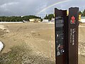
Tunnel Tappi Inclined Tunnel Line") is a Japanese funicular railway in Sotogahama, Aomori, operated by the Seikan Tunnel Museum. The 3 ft (914 mm) narrow-gauge...
2 KB (223 words) - 18:37, 5 September 2024

Tappi-Kaitei Station (category Sotogahama, Aomori)
(竜飛海底駅, Tappi-Kaitei-eki) was a railway station on the Kaikyo Line in Sotogahama, Aomori, Japan, operated by Hokkaido Railway Company (JR Hokkaido). The...
5 KB (348 words) - 10:34, 2 November 2023

Railway Company (JR Hokkaido). The line connected Naka-Oguni Station in Sotogahama, Aomori, through the Seikan Tunnel between Honshu and Hokkaido, to Kikonai...
4 KB (392 words) - 23:35, 4 September 2024

Minmaya, Aomori (category Sotogahama, Aomori)
(all from Higashitsugaru District), was merged to create the town of Sotogahama, and thus no longer exists as an independent municipality. At the time...
4 KB (165 words) - 22:58, 28 February 2024
Ōdai Yamamoto I Site (category Sotogahama, Aomori)
Ōdaiyamamoto ichi iseki) is a Jōmon archaeological site in the town of Sotogahama, Aomori Prefecture, in the Tōhoku region of northern Japan. Excavations...
11 KB (1,092 words) - 09:24, 14 June 2024
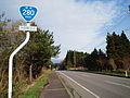
Nakadomari before ending at an intersection with National Route 280 in Sotogahama. In a unique feature, a 0.4-kilometer-long (0.25 mi) section of the route...
14 KB (800 words) - 03:16, 9 August 2024
kilometres (93.6 mi) from Aomori, north across the Tsugaru Peninsula to Sotogahama where the first section ends at the site of a former ferry to across the...
11 KB (708 words) - 08:53, 8 May 2024
Aomori Higashitsugaru 217.09 Imabetsu 今別町 Aomori Higashitsugaru 125.27 Sotogahama 外ヶ浜町 Aomori Higashitsugaru 230.29 Ajigasawa 鰺ヶ沢町 Aomori Nishitsugaru 343...
148 KB (122 words) - 00:34, 2 May 2024

Minmaya Station (category Sotogahama, Aomori)
terminal railway station on the JR East Tsugaru Line located in the town of Sotogahama, Aomori Prefecture, Japan. Minmaya Station is a terminal station on the...
4 KB (296 words) - 08:17, 9 February 2024
Hill Elevator Discovery Bay Elevator[citation needed] Aomori Prefecture Sotogahama, Seikan Tunnel Museum, Seikan Tunnel Tappi Shako Line Fukuoka Prefecture...
68 KB (5,244 words) - 18:10, 13 October 2024

center of Ōshū which stretched from the Shirakawa Barrier in the south to Sotogahama in present-day Aomori Prefecture. Kiyohira built the large temple complex...
13 KB (996 words) - 14:37, 30 September 2024

Minmaya was washed away in heavy rainfall in 2022, JR East and the town of Sotogahama closed the section indefinitely. The affected town of Imabetsu agreed...
7 KB (439 words) - 09:40, 11 September 2024

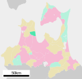
District in Aomori Prefecture green - current green/yellow - former extent in early Meiji period 1. - Itayanagi 2. – Tsuruta 3. - Nakadomari 4. – Sotogahama...
3 KB (278 words) - 19:41, 11 November 2023
east into Mutsu Bay. Aomori Prefecture Aomori Goshogawara Nakadomari Sotogahama The village has a cold humid continental climate (Köppen Cfb) characterized...
9 KB (457 words) - 22:05, 6 October 2024

Kanita, Aomori (category Sotogahama, Aomori)
(all from Higashitsugaru District), was merged to create the town of Sotogahama, and thus no longer exists as an independent municipality. At the time...
8 KB (201 words) - 22:58, 28 February 2024
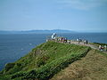
Cape Tappi (category Sotogahama, Aomori)
northern tip of the Tsugaru Peninsula within the borders of the town of Sotogahama in Aomori Prefecture. Much of the cape is also a part of the Tsugaru Quasi-National...
3 KB (228 words) - 06:13, 21 August 2023

Quasi-National Park. Aomori Prefecture Aomori Imabetsu Itayanagi Nakadomari Sotogahama Tsugaru Tsuruta Yomogita The city has a humid continental climate (Köppen...
16 KB (811 words) - 18:19, 3 October 2024

Naka-Oguni Station (category Sotogahama, Aomori)
Naka-Oguni-eki) is a railway station on the Tsugaru Line in the town of Sotogahama, Aomori, Japan, operated by East Japan Railway Company (JR East). Naka-Oguni...
4 KB (366 words) - 15:43, 4 February 2024

(Kumekawa) L/E M15 Tamaikari (Dewanoumi) L/E Tsurugidake (Tatsunami) L/E M16 Sotogahama (Dewanoumi) L/E East Jūryō West Tsunenobori (Dewanoumi) L/E J1 Asahikawa...
29 KB (2,257 words) - 05:14, 15 April 2024

limits of the Tsugaru Quasi-National Park. Aomori Prefecture Goshogawara Sotogahama The town has a cold humid continental climate (Köppen Cfb) characterized...
13 KB (531 words) - 06:16, 19 July 2024

the city of Aomori and its surrounding satellites, Hiranai, Imabetsu, Sotogahama, and Yomogita. The metropolitan area is defined as the Aomori Urban Employment...
6 KB (482 words) - 10:12, 26 January 2023

pottery in Japan was found at the Odai Yamamoto I site in the town of Sotogahama in the northwestern part of the prefecture. The relics found there suggest...
97 KB (9,259 words) - 14:23, 26 September 2024

tunnel in the world (~53.85 km) Tsugaru Tunnel - Tsugaru-Kaikyō Line Sotogahama-cho in Aomori Imabetsu-cho in Aomori ~5.88 km Ichinoseki Tunnel - Tōhoku...
6 KB (20 words) - 23:44, 14 December 2023
National Route 338 Hakodate Oirase, Aomori 219.6 National Route 339 Hirosaki Sotogahama 108.4 National Route 340 Rikuzentakata, Iwate Hachinohe 253.1 National...
39 KB (79 words) - 03:04, 9 August 2024

Tsugaru Quasi-National Park (category Sotogahama, Aomori)
borders of the municipalities of Hirosaki, Goshogawara, Tsugaru, Imabetsu, Sotogahama, Ajigasawa, Fukaura, and Nakadomari. Like all quasi-national parks in...
4 KB (298 words) - 14:28, 31 March 2024

Coordinates ACA 1632-001 Ōdai Yamamoto I Site 大平山元遺跡 Ōdai Yamamoto iseki Sotogahama Aomori excavated earthenware has been dated as early as 16500 BP 41°04′02″N...
13 KB (365 words) - 22:08, 31 August 2024