South Slocan is an unincorporated community in rural British Columbia with a population of approximately 100 people, many of whom are followers of the...
8 KB (718 words) - 09:53, 4 June 2024

Slocan City. The lake is drained by the Slocan River, which flows south from the lake's foot at Slocan City through the Slocan Valley to South Slocan...
5 KB (491 words) - 16:25, 29 July 2024
Look up slocan in Wiktionary, the free dictionary. Slocan may refer to: Slocan, British Columbia or Slocan City, a village in the Slocan Valley, British...
1 KB (200 words) - 06:45, 5 June 2017
FortisBC (section South Slocan)
(MW). They are the Corra Linn, Upper Bonnington, Lower Bonnington and South Slocan plants. The Corra Linn Dam was built in 1932 to control upstream storage...
27 KB (2,759 words) - 12:12, 17 September 2024

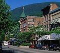
The Village of Slocan is in the West Kootenay region of southeastern British Columbia. The former steamboat landing and ferry terminal is at the mouth...
24 KB (1,950 words) - 17:20, 27 February 2024
British Columbia Highway 6 (category Slocan Valley)
States border and Nelson, and the Vernon-Slocan Highway between South Slocan and Vernon. Highway 6 is a north–south highway between Nelway and the Needles...
10 KB (685 words) - 05:50, 5 July 2024
Kootenay Railway rail corridor along the section of the Slocan Valley between South Slocan and Slocan that the Canadian Pacific Railway (CP) abandoned in...
4 KB (350 words) - 18:26, 29 January 2021
Hydro-Electric Power in Nelson". City of Nelson. Retrieved 2022-06-18. "South Slocan, British Columbia". Canadian Climate Normals 1971–2000 (in English and...
35 KB (2,738 words) - 23:00, 1 August 2024
The Nakusp and Slocan Railway (N&S) is a historic Canadian railway that operated in the West Kootenay region of southeastern British Columbia. The N&S...
11 KB (950 words) - 05:01, 10 June 2023

the Slocan Range presents the gradual slopes of the eastern boundary. Squeezed in between, Slocan Lake occupies the north, and Slocan River the south. In...
10 KB (932 words) - 22:30, 10 August 2023
since. Commercial demand led to two more dams at the falls, these were South Slocan Dam in 1928, and Corra Linn Dam, at the rapids above Bonnington in 1932...
96 KB (10,722 words) - 08:42, 21 May 2024
1X0: Robson 1Y0: Rossland 1Z0: Salmo 2B0: Silverton 2C0: Slocan 2E0: Slocan Park 2G0: South Slocan 2J0: Winlaw 2K0: Ymir V0H Southeast Okanagan and Boundary...
56 KB (218 words) - 16:40, 19 August 2024
1897, the CPR built a branch line from South Slocan up the Slocan Valley to Slocan City on the shore of Slocan Lake. Boats moved railway cars and loose...
3 KB (351 words) - 16:40, 3 November 2023

January 6, 2015. Touchstones Nelson:Museum of Art and History (2007). "South Slocan Dam". Retrieved January 7, 2015. Waymarking (June 10, 2013). "Kootenay...
145 KB (5,874 words) - 04:41, 7 June 2024
to South Slocan, where Highway 6 merges onto Highway 3A. The two highways proceed east for 22 km (14 mi) to Nelson, where Highway 6 diverges south. 34 km...
14 KB (1,137 words) - 09:38, 8 August 2024

Hat via Nelson and Lethbridge Troup toward Medicine Hat South Slocan toward Slocan City Slocan City – Nelson Terminus Preceding station Great Northern...
3 KB (147 words) - 02:33, 29 July 2024
School District 8 Kootenay Lake (redirect from South Nelson Elementary School)
Columbia. This includes the municipalities of Nelson, Creston, Kaslo and Slocan, British Columbia, as well as many rural communities in the Regional District...
4 KB (189 words) - 02:27, 2 September 2024
117.51806°W / 49.45667; -117.51806 (South Slocan) 54 1928 FortisBC South Sutton Creek Port Alberni 4.9 2005 South Sutton Creek Hydro Inc. Stokke Creek...
60 KB (1,981 words) - 21:45, 21 August 2024
kilometres (22 mi) south of Slocan. From north to south, Park, Koch, and Whiteley & Murray sidings were in close proximity on the former Slocan branch of the...
7 KB (372 words) - 03:42, 10 September 2023
route unreliable. In 1897, the CP built a C&K branch line from South Slocan up the Slocan Valley diverting much lake traffic from Robson. That year, the...
5 KB (616 words) - 02:59, 29 September 2024
Blewett Road Near South Slocan, British Columbia 49°27′32″N 117°30′33″W / 49.4590°N 117.5092°W / 49.4590; -117.5092 South Slocan Dam 49°27′23″N 117°31′05″W...
6 KB (90 words) - 08:45, 16 November 2022

Dam, City of Nelson Powerhouse, Upper Bonnington, Lower Bonnington and South Slocan. By diverting water past the older and smaller dams Kootenay Canal can...
8 KB (544 words) - 14:14, 22 August 2022
Abbotsford) South Shalalth South Slocan South Slope (within the City of Burnaby) South Sumas (within the City of Chilliwack) South Taylor South Wellington Southarm...
110 KB (5,935 words) - 10:07, 24 December 2023
Winlaw (category Populated places in the Slocan)
the Slocan River in the West Kootenay region of southeastern British Columbia. The locality is on BC Highway 6 about 20 kilometres (12 mi) south of Slocan...
21 KB (1,523 words) - 03:48, 10 September 2023
Mile Dam Seymour Dam (Seymour River) Seymour Falls Dam (Seymour River) South Slocan Dam Spillimacheen Dam Stave Falls Dam (Stave Lake) Terzaghi Dam a.k.a...
12 KB (1,158 words) - 19:40, 14 May 2024

The Kaslo and Slocan Railway (K&S) is a historic railway that operated in the West Kootenay region of southeastern British Columbia in western Canada....
14 KB (1,378 words) - 01:27, 16 June 2024
podcast Classic Showbiz. Nesteroff is of Doukhobor heritage and from South Slocan, British Columbia. He was expelled from high school for giving a speech...
35 KB (2,679 words) - 20:25, 16 July 2024

Similkameen, the southern half of the South Okanagan region, the Boundary Country, all of the West Kootenay region, the Slocan Valley, Lower (but not Upper) Arrow...
11 KB (310 words) - 01:33, 8 April 2023

and the Village of Slocan (known locally as Slocan City to distinguish it from the appellation "the Slocan" for the entire Slocan Valley). As a census...
15 KB (450 words) - 15:09, 26 April 2023

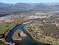
kilometres (1,270 sq mi) in area. The Slocan River originates at the south end of Slocan Lake and flows south past Slocan and Winlaw to join the Kootenay River...
4 KB (179 words) - 13:22, 1 November 2023