State Highway 79 (SH 79) is a New Zealand state highway connecting the South Canterbury communities of Rangitata, Geraldine, and Fairlie. Starting at...
4 KB (213 words) - 21:26, 22 July 2024

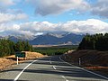
State Highway 8 is one of New Zealand's eight national highways. It forms an anticlockwise loop through the southern scenic regions of the Mackenzie Basin...
9 KB (711 words) - 19:09, 23 July 2024
This is a list of highways of the New Zealand state highway network and some touring routes. State highways are administered by Waka Kotahi, while all...
34 KB (320 words) - 05:52, 24 July 2024

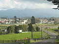
New Zealand. It is about 140 km south of Christchurch, and inland from Timaru, which is 38 km to the south. Geraldine is located on State Highway 79 between...
38 KB (3,451 words) - 20:56, 22 July 2024
State Highway 67 (SH 67) is a New Zealand state highway located in the northern parts of the South Island of New Zealand. It is 51.2 km long usually on...
4 KB (396 words) - 03:42, 22 September 2023
State Highway 80 (SH 80) is a South Island state highway in New Zealand. Known as Mount Cook Road, it is a road which is a popular tourist route between...
2 KB (178 words) - 08:37, 23 July 2024
State Highway 78 is a New Zealand State Highway connecting central Timaru with its port. It holds the record for New Zealand's shortest state highway...
2 KB (178 words) - 21:26, 22 July 2024
Route 79 Gukjido 79 New Zealand State Highway 79 N79 highway (Philippines) Interstate 79 U.S. Route 79 Alabama State Route 79 Arizona State Route 79 Arizona...
5 KB (336 words) - 22:43, 4 April 2024
on New Zealand's State Highway 1 (SH 1). All exits are unnumbered. All exits are unnumbered. All exits are unnumbered. List of New Zealand state highways...
31 KB (34 words) - 10:47, 10 April 2024
Inland Scenic Route (redirect from New Zealand State Highway 72)
Canterbury, New Zealand. In the north, the route starts in Amberley and in the south, it ends at Orari Bridge where it meets State Highway 79 (SH 79). It is...
2 KB (80 words) - 21:25, 22 July 2024
State Highway 77 is a state highway in New Zealand going through the inland parts of Central and Mid Canterbury between the towns of Ashburton and Darfield...
9 KB (535 words) - 21:26, 22 July 2024

State Highway 79 marker State Highway 80 marker State Highway 82 marker State Highway 83 marker State Highway 84 marker State Highway 85 marker State Highway...
125 KB (10,541 words) - 06:34, 24 July 2024

Canterbury region of the South Island of New Zealand. The estimated population was 950 as of June 2023. Being on state highway 8 between Christchurch (182 km,...
27 KB (2,299 words) - 20:56, 22 July 2024
road (Namibia) Mahendra Highway Rijksweg 1 New Zealand State Highway 1 New Zealand State Highway 1B New Zealand State Highway 1C NIC-1 Route nationale...
20 KB (1,269 words) - 07:41, 30 May 2024

Coast of New Zealand's South Island. The township is beside the Haast River, 3 kilometres (2 mi) south of Haast Junction, on State Highway 6. The Haast...
21 KB (2,192 words) - 22:01, 14 July 2024

The climate of New Zealand is varied due to the country's diverse landscape. Most regions of New Zealand belong to the temperate zone with a maritime...
36 KB (3,530 words) - 19:04, 16 July 2024

Rakarana) is a small beachside town located 48 km west of Hamilton, New Zealand on State Highway 23. It is known for its surfing, and volcanic black sand beaches...
79 KB (7,213 words) - 04:25, 27 April 2024

Māori: Ahuriri) is a city on the eastern coast of the North Island of New Zealand and the seat of the Hawke's Bay region. It is a beachside city with a...
59 KB (6,223 words) - 09:50, 21 July 2024

than 2 cm (0.79 in) across. The Hibiscus Coast Highway runs through the suburb. This was previously State Highway 1 and then State Highway 17. The majority...
10 KB (863 words) - 07:53, 4 February 2024
Witchdoctor", "Crawling Up a Hill"). Patrick Neville, 91, British-born New Zealand air force officer, chief of the Air Staff (1986–1988). François Xavier...
155 KB (11,508 words) - 14:33, 25 July 2024

(80 °F). Darfield is described by Statistics New Zealand as a small urban area, and covers 17.58 km2 (6.79 sq mi). It had an estimated population of 3...
20 KB (1,688 words) - 20:55, 22 July 2024
in the Taranaki Region of New Zealand's North Island. It is 16 kilometres (10 mi) southeast of New Plymouth on State Highway 3, close to Mount Taranaki...
23 KB (2,368 words) - 05:49, 4 May 2024

crore (US$64 billion) by 2021–22. Roads in India New Zealand state highway network State highways (Italy) "NH and SHs". MOSPI. "Bharat Mala: PM Narendra...
9 KB (392 words) - 14:33, 11 May 2024
Marlborough District (redirect from Marlborough, New Zealand)
served by four state highways: State Highway 1, State Highway 6, State Highway 62, and State Highway 63. State Highway 1 is the main highway in the region...
28 KB (2,309 words) - 22:16, 14 July 2024

Canterbury, on the east coast of the South Island of New Zealand. It is located on State Highway 1, approximately 112 kilometres (70 mi) north of Christchurch...
19 KB (1,606 words) - 20:55, 22 July 2024
List of rivers of New Zealand "Fish River Bridge". 2004. Peter Dowling, ed. (2004). Reed New Zealand Atlas. Reed Books. pp. map 79. ISBN 0-7900-0952-8...
3 KB (168 words) - 21:48, 6 June 2024

Wellington (redirect from Wellington New Zealand)
city in New Zealand, and is the administrative centre of the Wellington Region. It is the world's southernmost capital of a sovereign state. Wellington...
161 KB (13,906 words) - 09:53, 25 July 2024

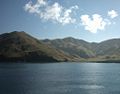
Lake Pukaki (redirect from Lake Pukaki, New Zealand)
running north–south along the northern edge of the Mackenzie Basin on New Zealand's South Island. The others are Lakes Tekapo and Ōhau. All three lakes...
15 KB (1,336 words) - 20:36, 22 July 2024

Christchurch, New Zealand. The suburb is split by State Highway 1, with the bulk of Harewood's residential areas to the east of the highway and its industrial...
7 KB (665 words) - 06:19, 12 July 2024

May 2023. Retrieved 27 May 2023. "What is the highest state highway in New Zealand?". New Zealand Transport Agency. Archived from the original on 27 March...
75 KB (6,258 words) - 09:45, 25 July 2024