
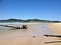
Teewah Beach is a beach that extends from Double Island Point in Cooloola, Gympie Region through Noosa North Shore in the Shire of Noosa to the Noosa...
4 KB (489 words) - 23:59, 23 April 2022
mineral sand industry operating in the Teewah Beach area. The ferries are now used to provide access to Teewah Beach, Cooloola National Park and the growing...
933 bytes (84 words) - 10:16, 16 July 2024
Scandinavian origin. It ran aground on Teewah Beach in South East Queensland, Australia on 6 July 1973 and remained on the beach for 34 years until its removal...
10 KB (978 words) - 03:28, 26 May 2024

Mission Beach Newell Beach Nudgee Beach Palm Beach Castaways Beach Teewah Beach Trinity Beach Whitehaven Beach Wonga Beach Aldinga Beach Baudin Beach Christies...
10 KB (564 words) - 09:16, 22 October 2024

Pasha Bulker (section Storm and beaching)
MV Sygna on Stockton beach, some 8 km (5 mi) further north, and Cherry Venture, which was beached during a storm in 1973 on Teewah Beach in Queensland. "Drake...
25 KB (2,604 words) - 08:28, 18 December 2024
the beach.[citation needed] Between 2008 and Teewah, Noosa North Shore (and the rest of the Shire of Noosa) was within Sunshine Coast Region. "Teewah (entry...
3 KB (145 words) - 02:33, 30 November 2024

to 2018 found it in scattered locations in its suitable habitat from Teewah Beach to Inskip Point on the mainland and along the east coast of near K'Gari...
23 KB (2,668 words) - 23:22, 5 January 2025

"depredations" in the Mary Valley to the coast and massacred them at Teewah Beach. In October 1855, Bligh was sent to the Clarence River area to take charge...
17 KB (2,027 words) - 15:48, 22 May 2024

Queensland portal Wolf Rock, just off the point Teewah Beach, stretches south from Double Island Point Rainbow Beach, stretches west from Double Island Point...
9 KB (688 words) - 00:53, 8 November 2024
Singapore-registered cargo ship Cherry Venture was driven aground in a storm at Teewah Beach, Australia, where it would remain until scrapped in 2007. The captain...
25 KB (2,439 words) - 16:42, 29 October 2024

Cherry Venture Singapore 6 July 1973 A cargo ship that ran aground on Teewah Beach. 25°57′42.00″S 153°10′26.14″E / 25.9616667°S 153.1739278°E / -25.9616667;...
76 KB (896 words) - 17:23, 17 November 2024
Morning Bay, New South Wales, Australia Teewah, Queensland, Australia (only accessible via offroad driving on a beach) Tufi, Oro, Papua New Guinea Wondabyne...
6 KB (503 words) - 19:52, 3 January 2025

could pass by the Double Island Point Lighthouse. Walkers also pass Teewah Beach and the Noosa River, and cross the Cooloola Sandpatch. Four campsites...
3 KB (265 words) - 16:16, 15 October 2023

MV Sygna. 6 July 1973, the cargo ship Cherry Venture ran aground on Teewah Beach in South East Queensland during the storm. June 1967, a series of east...
28 KB (3,005 words) - 12:02, 4 January 2025
Point. From Double Island Point, Rainbow Beach extends to the west and then to the north, while Teewah Beach stretches for many kilometres to the south...
7 KB (529 words) - 06:38, 25 May 2024
Cherry Venture Singapore The cargo ship was driven aground in a storm at Teewah Beach, Australia. She was scrapped in situ in 2007. Clive Steele Philippines...
63 KB (1,357 words) - 23:46, 16 July 2024
contains many sections of the Great Sandy National Park and the small town of Teewah. Access to the locality is provided by the cable ferry, Noosa River Ferry...
8 KB (574 words) - 05:11, 22 September 2024

Lake Cootharaba north of present-day Noosa, onto the ocean beach near present-day Teewah. Here they met the waiting Lieutenant Otter and his small band...
12 KB (1,067 words) - 11:10, 17 August 2024

Neolithic era, Noosa's coast experienced a change in sea level rises when its beaches and waterways began to take shape. The Noosa area was originally home to...
37 KB (3,135 words) - 12:07, 3 December 2024

managed by Transport and Main Roads Toolara Road on the north bank of Teewah Creek (25°55′51″S 153°00′56″E / 25.9309°S 153.0155°E / -25.9309; 153...
20 KB (1,758 words) - 05:05, 10 November 2024

mostly covered by sand dunes and has two major tributaries—Kin Kin Creek and Teewah Creek. The Noosa River enters the Coral Sea between Noosa Heads and Noosa...
8 KB (696 words) - 08:47, 4 March 2024