
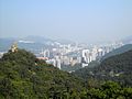
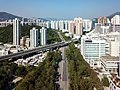
Tsing Sha Highway (Chinese: 青沙公路) is a major expressway in Hong Kong, which links the island of Tsing Yi to Sha Tin. The road is part of Route 8, which...
12 KB (673 words) - 01:01, 18 December 2023

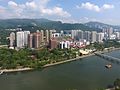
carriageway motorway that links Lantau Island, Tsing Yi Island, Cheung Sha Wan in West Kowloon, and Sha Tin in the southeast New Territories of Hong Kong...
11 KB (640 words) - 10:14, 5 October 2023

whereas Sha Tin Heights Tunnel is linked at the northern end to Che Kung Miu Road and Tai Po Road. The tunnels are part of the Tsing Sha Highway of Route...
7 KB (573 words) - 02:53, 15 October 2022

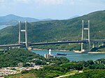
Tsing Ma Bridge is a bridge in Hong Kong. It is the world's 16th-longest span suspension bridge, and was the second longest at the time of its completion...
23 KB (2,513 words) - 10:03, 24 March 2024

Cheung Tsing Highway (Chinese: 長青公路; Cantonese Yale: chèuhng chīng gūng louh) is a highway of Route 3 between Cheung Tsing Tunnel and North West Tsing Yi...
7 KB (386 words) - 01:19, 9 May 2024
the Tsing Sha Highway on Route 8 (consisting of the Eagle's Nest Tunnel and Sha Tin Heights Tunnel) in 2008. Other major roads in the area include Sha Lek...
18 KB (1,944 words) - 08:47, 6 July 2024
and Tsing Sha Highway over East Rail (two levels of flyovers and a footbridge over railway tracks) Tsing Ma Bridge (road and rapid transit) Tsing Kwai...
15 KB (1,438 words) - 19:36, 16 June 2024

Lantau Link (category Tsing Yi)
a roadway in Hong Kong forming part of Route 8 linking Lantau Island to Tsing Yi, from which other roads lead to the urban areas of Kowloon and the rest...
6 KB (378 words) - 10:05, 22 March 2024
connection between Sha Tin and Sai Kung. The T3 Highway (Tsing Sha Highway) and Route No. 8 (Cheung Sha Wan to Sha Tin section) was completed in March 2008....
6 KB (580 words) - 11:12, 13 June 2024

Other highways in Kowloon and New Territories: Tsing Kwai Highway - Route 3 Tuen Mun Road - Route 9 West Kowloon Highway - Route 3 Tsing Long Highway - Route...
5 KB (224 words) - 20:27, 27 November 2021
Kowloon Highway Tsing Kwai Highway Cheung Tsing Bridge and Cheung Tsing Tunnel (within Tsing Ma Control Area) Cheung Tsing Highway (within Tsing Ma Control...
15 KB (346 words) - 10:09, 5 October 2023

Stonecutters Bridge (category Tsing Yi)
respectively. The bridge is part of Hong Kong's Route 8, connecting Sha Tin, Cheung Sha Wan, Tsing Yi island, Ma Wan and Lantau Island. Other major constructions...
10 KB (953 words) - 04:30, 22 July 2024
remaining portion of Tai Po Road - Sha Tin until the Racecourse Interchange, where it continues via the 12.3 km-long Tolo Highway (opened in 1985) to Lam Kam...
19 KB (508 words) - 14:14, 6 December 2023
List of streets and roads in Hong Kong (redirect from Hong Kong Highways)
(Airport) – Tsing Ma Bridge – Tsing Yi – Stonecutters Island – Lai Chi Kok – Sha Tin to join Route 9. Route 9: Shing Mun Tunnel – Tai Wai – Sha Tin – Ma...
29 KB (3,313 words) - 14:56, 5 June 2024
and roads in Hong Kong Tate's Cairn Highway Tsing Kwai Highway Tuen Mun Road West Kowloon Highway Google Maps of Sha Tin Road "Open Source Routing Machine"...
5 KB (203 words) - 09:48, 7 April 2024
under the same contract as the KSMB. The viaduct connects the KSMB to the Tsing Ma Bridge, forming the Lantau Link, which was built to provide access to...
9 KB (884 words) - 10:04, 24 March 2024
the road climbs over Ta Shui Wan and Tsing Chau Wan to meet the Lantau Link and its bridges. The North Lantau Highway was built as part of the Airport Core...
14 KB (1,301 words) - 18:09, 15 August 2023

Kwai Chung and Tsing Yi Island. The Tsing Ma Bridge, leading to the Hong Kong International Airport through the North Lantau Highway, starts at the northwestern...
12 KB (1,241 words) - 14:57, 22 June 2024

opened to vehicular traffic in its entirety (excluding the proposed Lantau - Tsing Yi Link) by 2033, and no later than 2036. Route 11 is the culmination of...
7 KB (489 words) - 22:02, 16 October 2023
Tai Wai Tunnel, Tsing Sha Highway, New Territories, Hong Kong; an expressway tunnel in Sha Tin district Tai Wai Road (大圍道), Tai Wai, Sha Tin, New Territories...
3 KB (503 words) - 23:20, 11 September 2023

Route 1 (Hong Kong) (section Sha Tin)
Diverging from Sha Tin Road to the west outside Pok Hong Estate, the new route would cross the Shing Mun River and merge into Tsing Sha Highway (Route 8) and...
22 KB (1,573 words) - 17:46, 22 December 2023

Fanling Highway, San Tin Highway and Sha Tau Kok Road. Fanling station Sheung Shui station Lo Wu station (terminus of East Rail line) Sha Tau Kok (road)...
8 KB (494 words) - 08:52, 6 July 2024

on. Large areas were gained by land reclamations in Sha Tin, Tsuen Wan, Tuen Mun, Tai Po, Tsing Yi, Ma On Shan, Tin Shui Wai, Tseung Kwan O and Tung...
22 KB (2,821 words) - 00:13, 18 March 2024
opening. The entire road is in Kwai Tsing District. List of streets and roads in Hong Kong Penny's Bay Highway Sha Lek Highway Portals: Roads Hong Kong Public...
12 KB (1,024 words) - 18:37, 1 May 2024

Tsing Long Highway (Chinese: 青朗公路; Cantonese Yale: Tsīng Lóhng Gūnglouh; Jyutping: cing1 long5 gung1 lou6; pinyin: Qīng Lǎng Gōnglù) is a motorway of Route...
7 KB (246 words) - 06:21, 18 June 2024
Avenue South Underpass Sai Sha Road Ma On Shan Underpass Sai Sha Road Clear Water Bay Underpass Tsing Yi Road-Kwai Tsing Bridge Underpass Yi Pei Chun...
26 KB (1,442 words) - 11:03, 17 July 2024
Tsim Sha Tsui Tsim Sha Tsui MTR Station Tsim Sha Tsui Ferry Pier Tsim Sha Tsui Fire Station Tsing Kwai Highway Tsing Lai Bridge Tsing Leng Tsui Tsing Long...
62 KB (6,716 words) - 18:46, 12 July 2024

northeast corner of the Tsing Yi Island as a result of land reclamation Rumsey Rock – now a part of shore of between Tsim Sha Tsui East and Hung Hom Stonecutters...
26 KB (2,688 words) - 04:55, 9 April 2024

Nathan Road, Tsim Sha Tsui, then going out to West Kowloon using Austin Road, followed by West Kowloon Highway and Tsing Kwai Highway, where half-marathoners...
40 KB (3,256 words) - 03:24, 28 April 2024

Road and continues as Ching Cheung Road, bypassing Sham Shui Po and Cheung Sha Wan before terminating at Kwai Chung and joins Route 5 again. Some sections...
11 KB (336 words) - 19:55, 11 May 2024