The Vale–West Highway No. 451 is an Oregon state highway in Malheur County. It runs east–west for approximately ten miles (16 km) between two intersections...
4 KB (276 words) - 12:22, 10 September 2023

U.S. Route 20 in Oregon (redirect from Central Oregon Highway)
US 20 continues east through Juntura and Vale. In Vale, US 20 travels concurrent with US 26, and the two highways continue east to Cairo Junction, south...
19 KB (951 words) - 22:11, 20 August 2024

Canning Vale is a southern suburb of Perth, 22 km (13.7 mi) from the central business district. Its local government areas are the City of Canning (west of...
11 KB (1,397 words) - 06:40, 14 August 2024
from the intersection with Hume Highway at the Cross Roads (today Hoddles Cross Roads) west of Sutton Forest to Moss Vale (and continuing north via Bowral...
11 KB (843 words) - 00:22, 6 March 2023

beginning of the north-western section of the highway) starts at the interchange with CityLink in Pascoe Vale South and heads east as a four-lane, single-carriageway...
31 KB (1,518 words) - 05:20, 23 June 2024

approximately 100 km south west on the Hume Highway from Sydney. It is situated 2 km north-west of Aylmerton, 5 km from the Hume Highway and 12 km drive to Mittagong...
5 KB (488 words) - 15:43, 21 August 2022
Bundaberg–Gin Gin Road (redirect from Bundaberg–Miriam Vale Road)
of the Bruce Highway. This road intersects with the following state-controlled roads: Isis Highway Moore Park Road Bundaberg–Miriam Vale Road The Cedars...
13 KB (1,025 words) - 16:41, 25 July 2024

Moss Vale is a town in the Southern Highlands of New South Wales, Australia, in the Wingecarribee Shire. It is located on the Illawarra Highway, which...
17 KB (1,477 words) - 04:19, 9 July 2024

Mittagong, Bowral and Moss Vale. From outside Berrima, Hume Highway stretches 426 kilometres (265 mi) southwest by west, bypassing Sutton Forest, Marulan...
94 KB (10,500 words) - 08:53, 25 August 2024
Martin Highway is a highway in Trinidad and Tobago. It runs west from Cocorite to Diamond Vale. The highway meets the Audrey Jeffers Highway in Cocorite...
727 bytes (42 words) - 19:53, 24 March 2024

Gin Gin, Miriam Vale and Mount Larcom before reaching Rockhampton.[citation needed] With the completion of Section C of the Bruce Highway – Cooroy to Curra...
103 KB (5,398 words) - 07:55, 6 August 2024

U.S. Route 26 (redirect from United States Highway 26)
U.S. Highway 26 (US 26) is an east–west United States Numbered Highway that runs from Seaside, Oregon, to Ogallala, Nebraska. When the U.S. Numbered Highway...
15 KB (1,416 words) - 14:23, 10 January 2024
U.S. Route 20 (redirect from United States Highway 20)
U.S. Route 20 or U.S. Highway 20 (US 20) is an east–west United States Numbered Highway that stretches from the Pacific Northwest east to New England...
44 KB (4,425 words) - 18:24, 26 August 2024
state highway system: named state highways and numbered state routes. Named highways, such as the Pacific Highway No. 1 or the North Umpqua Highway East...
93 KB (600 words) - 15:53, 11 May 2024

Interstate 68 (redirect from Corridor E (Appalachian Development Highway System))
15-mile (182.10 km) Interstate Highway in the U.S. states of West Virginia and Maryland, connecting I-79 in Morgantown, West Virginia, east to I-70 in Hancock...
58 KB (4,888 words) - 22:53, 16 August 2024

7 kilometres (1.1 mi), Roe Highway enters the City of Kalamunda LGA, bordering the suburbs of High Wycombe and Maida Vale and then reaches Kalamunda Road...
40 KB (3,630 words) - 07:36, 26 July 2024

U.S. Route 28 (redirect from United States Highway 28)
U.S. Route 28 (US 28) was an east–west United States Numbered Highway that was located completely in the U.S. state of Oregon. It connected US 99 in Eugene...
5 KB (302 words) - 03:30, 23 January 2024

U.S. Route 16 (redirect from United States Highway 16)
U.S. Highway 16 (US 16) is an east–west United States Numbered Highway between Rapid City, South Dakota, and Yellowstone National Park in Wyoming. The...
17 KB (1,106 words) - 21:12, 20 May 2024
Kalamunda Road to the north, Dundas Road to the west, Maida Vale Road to the south, and Roe Highway to the east. The suburb's growth is mainly in this...
11 KB (1,298 words) - 11:58, 9 April 2024

Pymble, New South Wales (redirect from Pymble West)
Shore railway line. Pymble is bisected by the Pacific Highway, and the intersection of Mona Vale Road and Ryde Road is the southern boundary of the Suburb...
17 KB (2,133 words) - 04:23, 27 June 2024
U.S. Route 26 in Oregon (redirect from Sunset Highway (Oregon))
the John Day Highway No. 5 through John Day to US 20 in Vale. The remainder of US 26 in Oregon overlaps US 20 on the Central Oregon Highway No. 7 to the...
25 KB (1,490 words) - 15:33, 21 March 2024
kilometres (5.0 mi) west of the town of Kingston. The 2016 census recorded a population of 351 for the state suburb of Leslie Vale. Leslie Vale was gazetted...
3 KB (191 words) - 17:25, 25 July 2024

River Vale is a township in Bergen County, in the U.S. state of New Jersey. River Vale is the easternmost municipality in an area of the county referred...
73 KB (8,240 words) - 17:20, 8 August 2024
population of 1,444 people. Hodgson Vale is 12 kilometres (7 mi) south of the city centre via New England Highway. The highway passes through the locality from...
6 KB (436 words) - 12:06, 26 May 2024

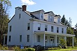
States. It was located about 200 yards (180 m) from Virginia State Highway 123 just west of the Capital Beltway. Prior to 1811, the residence was owned by...
2 KB (185 words) - 21:25, 19 May 2024

Vale is a small suburb of Wollongong in the Illawarra region of New South Wales, Australia. Russell Vale straddles the Princes Highway. Russell Vale was...
4 KB (409 words) - 14:48, 29 July 2024

Kashmir Valley (redirect from Vale of Kashmir)
The Kashmir Valley, also known as the Vale of Kashmir, is an intermontane valley in northern Jammu and Kashmir, a region in Indian-administered Kashmir...
11 KB (1,098 words) - 09:17, 23 March 2024
Caledon and Orangeville, and west of Vaughan. It is accessible from Highway 427 via Highway 7, and The Gore and the Highway 407 at the Goreway interchange...
7 KB (324 words) - 23:31, 8 February 2024

U.S. Route 40 (redirect from United States Highway 40)
S. Highway 40 (US 40), also known as the Main Street of America (a nickname shared with U.S. Route 66), is a major east–west United States Highway traveling...
77 KB (8,335 words) - 01:42, 5 August 2024
to the north. To the west is Piney Mountain and Frostburg. LaVale is located along the National Road, one of the original highways built in the United...
10 KB (839 words) - 13:55, 19 March 2024