
The Vizovice Highlands (Czech: Vizovická vrchovina) are highlands and a geomorphological mesoregion of the Czech Republic. It is located in the Zlín and...
4 KB (369 words) - 08:54, 4 April 2024

administrative part of Vizovice. Vizovice is located about 12 kilometres (7 mi) east of Zlín. It lies in the Vizovice Highlands. The highest point is a...
7 KB (543 words) - 20:34, 20 August 2024

mountain of Velká Javořina (970 m). The Hostýn-Vsetín Mountains and Vizovice Highlands pass south of the Moravian-Silesian Beskids mountain range. On the...
17 KB (1,618 words) - 15:00, 17 May 2024

town of Otrokovice. The territory of the city entirely lies in the Vizovice Highlands. The highest point is the hill Tlustá hora at 458 m (1,503 ft) above...
25 KB (2,640 words) - 12:59, 17 August 2024

territory lies in the Lower Morava Valley and the eastern part in the Vizovice Highlands. The highest point is at 337 m (1,106 ft) above sea level. The town...
14 KB (1,300 words) - 16:50, 13 August 2024

Uherské Hradiště and 22 km (14 mi) south of Zlín. It lies in the Vizovice Highlands. The highest point is at 389 m (1,276 ft) above sea level. The Olšava...
12 KB (1,116 words) - 12:44, 18 May 2024

pahorkatina), rugged highlands along the Myjava River Váh Valley Land (SK: Považské podolie) along the Váh River Vizovice Highlands (CZ: Vizovická vrchovina)...
2 KB (193 words) - 10:25, 21 March 2022

(SK: Myjavská pahorkatina) Váh Valley Land (SK: Považské podolie) Vizovice Highlands (CZ: Vizovická vrchovina) (CZ: Západobeskydské podhůří, PL: Pogórze...
32 KB (2,939 words) - 20:48, 9 July 2024

Ždánice Forest (northwest), Chřiby (small part in the northeast), Vizovice Highlands (east), White Carpathians (southeast), and Chvojnice Hills (a negligible...
11 KB (699 words) - 08:56, 15 August 2024

neighbouring Otrokovice. Most of the municipal territory lies in the Vizovice Highlands, but the area on the right bank of the Morava extends into the Chřiby...
9 KB (742 words) - 05:51, 21 May 2024
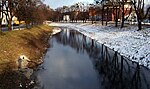
floods. The Dřevnice originates in the territory of Držková in the Vizovice Highlands at the elevation of 568 m (1,864 ft) and flows to Otrokovice, where...
4 KB (309 words) - 14:03, 23 November 2023

mountainous. The territory extends into six geomorphological mesoregions: Vizovice Highlands (most of the territory), White Carpathians (southeast), Hostýn-Vsetín...
11 KB (655 words) - 06:33, 15 August 2024

of Zlín. The eastern part of the municipal territory lies in the Vizovice Highlands and the western part liesin the southern tip of the Upper Morava Valley...
11 KB (974 words) - 12:11, 18 May 2024
kilometres (9 mi) south of Zlín. It lies in the hilly landscape in the Vizovice Highlands. The highest point is the hill Brda at 600 m (2,000 ft) above sea...
12 KB (1,113 words) - 19:19, 21 May 2024

pahorkatina) IXB-4 482 235.2 417 (Babí lom) Slovak-Moravian Carpathians Vizovice Highlands (Vizovická vrchovina) IXC-1 1,399 338.7 753 (Klášťov) White Carpathians...
17 KB (292 words) - 04:08, 24 July 2024

neighbouring Uherské Hradiště. It lies on the border between the Vizovice Highlands and Lower Morava Valley. The highest point is the hill Hluboček at...
8 KB (541 words) - 09:10, 11 July 2024

Hostýn-Vsetín Mountains (southeast), Litenčice Hills (west) and Vizovice Highlands (small part in the south). The highest point of the district is the...
11 KB (633 words) - 06:33, 15 August 2024

located about 24 kilometres (15 mi) southeast of Zlín. It lies in the Vizovice Highlands. The highest point is at 532 m (1,745 ft) above sea level. The Říka...
7 KB (450 words) - 06:02, 21 May 2024

which is surrounded by highlands and mountains. The territory extends into five geomorphological mesoregions: Vizovice Highlands (most of the territory)...
12 KB (704 words) - 06:33, 15 August 2024

Hostýn-Vsetín Mountains (most of the territory), Maple Mountains (southeast), Vizovice Highlands (southwest), Rožnov Furrow (a strip in the north), Moravian-Silesian...
11 KB (620 words) - 06:33, 15 August 2024

is located about 5 kilometres (3 mi) east of Zlín. It lies in the Vizovice Highlands. The highest point is at 521 m (1,709 ft) above sea level. The municipality...
5 KB (311 words) - 08:51, 21 May 2024

60 km (37 mi) southeast of Brno. It lies on the border between the Vizovice Highlands and the Lower Morava Valley. The highest point is at 227 m (745 ft)...
5 KB (312 words) - 09:36, 2 July 2024

kilometres (7 mi) west of Zlín. It lies on the border between the Vizovice Highlands and Upper Morava Valley. The highest point is at 308 m (1,010 ft)...
5 KB (250 words) - 10:41, 21 May 2024

lies in the Lower Morava Valley and the eastern part lies in the Vizovice Highlands. The highest point is the hill Radošov with an elevation of 246 metres...
9 KB (715 words) - 10:08, 20 May 2024

southeast of Zlín. It lies on the border of the White Carpathians and the Vizovice Highlands, at the northern tip of the White Carpathians Protected Landscape...
8 KB (526 words) - 10:37, 21 May 2024

Uherské Hradiště and 25 km (16 mi) south of Zlín. It lies in the Vizovice Highlands. The highest point is the hill Černá hora at 364 m (1,194 ft) above...
6 KB (397 words) - 07:44, 2 July 2024

Uherské Hradiště and 28 km (17 mi) south of Zlín. It lies in the Vizovice Highlands. The highest point is at 360 m (1,180 ft) above sea level. The Nivnička...
5 KB (232 words) - 07:42, 2 July 2024

is located about 9 kilometres (6 mi) east of Zlín. It lies in the Vizovice Highlands. The highest point is at 415 m (1,362 ft) above sea level. The town...
6 KB (380 words) - 10:42, 21 May 2024

Uherské Hradiště and 28 km (17 mi) south of Zlín. It lies in the Vizovice Highlands. The highest point is at 366 m (1,201 ft) above sea level. The Okluky...
8 KB (605 words) - 07:14, 2 July 2024

east of Hodonín and 39 km (24 mi) southwest of Zlín. It lies in the Vizovice Highlands. The highest point is at 436 m (1,430 ft) above sea level. The White...
6 KB (304 words) - 07:36, 3 July 2024