
The Wallowa River is a tributary of the Grande Ronde River, approximately 55 miles (89 km) long, in northeastern Oregon in the United States. It drains...
7 KB (554 words) - 02:22, 15 April 2024
Wallowa may refer to: Wallowa, Oregon Wallowa County, Oregon Wallowa Lake Wallowa Lake State Park Wallowa Mountains Wallowa River Acacia calamifolia,...
497 bytes (88 words) - 13:01, 5 January 2021

that Wallowa is derived from a Nez Perce word for "winding water". The journals of Lewis and Clark Expedition record the name of the Wallowa River as Wil-le-wah...
26 KB (2,369 words) - 18:45, 26 April 2024

southeast in southwestern Wallowa County and eastern Union County between the Blue Mountains to the west and the Snake River to the east. The range is...
19 KB (1,709 words) - 17:35, 23 September 2024

Wallowa River Rest Area is a state park in the U.S. state of Oregon, administered by the Oregon Parks and Recreation Department. List of Oregon state...
1 KB (44 words) - 01:05, 24 August 2024

Columbia Plateau, bounded by the Blue Mountains and Wallowa Mountains to the west of Hells Canyon. The river flows generally northeast from its forested headwaters...
83 KB (9,227 words) - 10:02, 28 September 2024

Wallowa (/wəˈlaʊwə/) is a city in Wallowa County, Oregon, United States. The population was 808 at the 2010 census. The Wallowa Valley is within the traditional...
18 KB (1,407 words) - 21:07, 22 May 2024

valley. This fan was created by the Wallowa River transporting debris into the valley. The sediment left by the river was pushed by a series of glaciers...
14 KB (1,662 words) - 06:48, 7 August 2024

with tribal centre in the river valleys of the Imnaha River, the Minam River and the Wallowa River (Wal'awa – "the winding river"). Their territory extended...
73 KB (9,228 words) - 00:57, 11 October 2024

Retrieved March 12, 2016. National Performance of Dams Program (2016). "Wallowa Lake Reservoir". Archived from the original on March 13, 2016. Retrieved...
145 KB (5,874 words) - 04:41, 7 June 2024
The Wallowa–Whitman National Forest is a United States National Forest in the U.S. states of Oregon and Idaho. Formed upon the merger of the Wallowa and...
18 KB (1,808 words) - 01:06, 8 October 2024

Sacajawea Peak (category Landforms of Wallowa County, Oregon)
Sacajawea Peak is a peak in the Wallowa Mountains, in the U.S. state of Oregon. It is in the Eagle Cap Wilderness and the Wallowa–Whitman National Forest. At...
8 KB (699 words) - 19:19, 9 August 2024

The Minam River is a tributary of the Wallowa River, 51 miles (82 km) long, in northeastern Oregon in the United States. It drains a rugged wilderness...
8 KB (538 words) - 13:58, 15 June 2022

have not always inhabited the state but came to Oregon in the 1960s; the Wallowa Valley herd numbered about 60 as of 2013[update]. Gray wolves were extirpated...
196 KB (16,672 words) - 12:34, 19 September 2024
the Columbia River and south to the border with California. Eastern Oregon Baker, Grant, Harney, Malheur, Morrow, Umatilla, Union, Wallowa counties Hermiston...
10 KB (64 words) - 19:18, 4 March 2022

River Trask River Treat River Tualatin Sherman River Tumalo Creek Tumtum River Umatilla River Umpqua River Walla Walla River Wallooskee River Wallowa...
97 KB (11,400 words) - 16:41, 4 August 2024

Lostine, Oregon (category Cities in Wallowa County, Oregon)
about halfway between Wallowa and Enterprise. Nearby is the Lostine River, a tributary of the Wallowa River, east of the Wallowa Mountains of northeastern...
10 KB (881 words) - 00:18, 5 November 2023

Hells Canyon (category Landforms of Wallowa County, Oregon)
Area which is also located in part of the Wallowa-Whitman National Forest. It is North America's deepest river gorge at 7,993 feet (2,436 m), running deeper...
18 KB (1,775 words) - 05:39, 11 August 2024
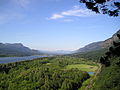
The Columbia River Gorge is a canyon of the Columbia River in the Pacific Northwest of the United States. Up to 4,000 feet (1,200 m) deep, the canyon...
17 KB (1,573 words) - 02:02, 21 October 2023

Eagle Cap Wilderness (category Protected areas of Wallowa County, Oregon)
is a wilderness area located in the Wallowa Mountains of northeastern Oregon (United States), within the Wallowa–Whitman National Forest. The wilderness...
17 KB (1,483 words) - 06:49, 14 October 2024

Country near the mouth of the Columbia River during the winter of 1805–1806. Located along the Lewis and Clark River at the north end of the Clatsop Plains...
15 KB (1,836 words) - 04:25, 14 January 2024

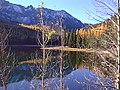
Wallowa Lake, near the city of Joseph in Wallowa County. The town of Wallowa Lake is situated next to the park. Wallowa Lake State Park has a variety of activities...
2 KB (182 words) - 01:43, 3 August 2023

many small mammals are common in the park. River otter and beaver are found along the park's Crooked River frontage. The Smith Rock area hosts many types...
25 KB (2,930 words) - 12:56, 4 May 2024

are the white-peaked Cascade Range volcanoes to the north, the Columbia River Plateau to the east, and the Western Cascades and the more-distant Klamath...
36 KB (3,729 words) - 22:58, 4 October 2024
Rock Wilderness at 19,620 acres (79 km2), located partially within the Wallowa–Whitman National Forest The hottest temperature recorded in the Malheur...
10 KB (549 words) - 01:05, 8 October 2024

Multnomah Falls (category Columbia River Gorge)
Columbia River Gorge, east of Troutdale, between Corbett and Dodson, Oregon, United States. The waterfall is accessible from the Historic Columbia River Highway...
25 KB (2,457 words) - 08:48, 22 July 2024

Eagle Cap Wilderness of the Wallowa Mountains in the Wallowa–Whitman National Forest and joins the Wallowa River at Wallowa. In 1988, the upper 16 miles...
8 KB (504 words) - 13:25, 15 June 2022

The Historic Columbia River Highway is an approximately 75-mile-long (121 km) scenic highway in the U.S. state of Oregon between Troutdale and The Dalles...
40 KB (3,950 words) - 18:30, 10 August 2024

Rogue River–Siskiyou National Forest is a United States National Forest in the U.S. states of Oregon and California. The formerly separate Rogue River and...
13 KB (951 words) - 01:05, 8 October 2024

Stretching for more than 8 miles (13 km) on hillsides overlooking the Willamette River, it is one of the country's largest urban forest reserves. The park, a major...
48 KB (5,135 words) - 13:43, 16 August 2024