
Whau Ward is an Auckland Council ward which elects one councillor and covers the Whau local board area. The current councillor is Kerrin Leoni. Whau ward...
8 KB (539 words) - 02:07, 3 June 2024

The Whau Local Board is one of the 21 local boards of the Auckland Council. It is the only local board overseen by the council's Whau Ward councillor....
7 KB (334 words) - 23:32, 28 June 2024

Ōtara-Papatoetoe, Puketāpapa, Upper Harbour, Waitākere Ranges, Waitematā and Whau. Rural townships and localities outside of the metropolitan urban limits...
36 KB (445 words) - 19:46, 1 June 2024
Board and Auckland Council. It is within the council's Whau Ward. The area takes its name from Whau River estuary arm of the Waitematā Harbour, which extends...
2 KB (168 words) - 02:11, 12 January 2023

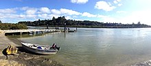
The Whau River (Māori pronunciation: [ɸau]) is an estuarial arm of the southwestern Waitemata Harbour (rather than a river) within the Auckland metropolitan...
11 KB (902 words) - 08:01, 25 April 2024

2022 Auckland local elections (section Whau ward (1))
mayor. Twenty members were elected to the Auckland Council, across thirteen wards, using the first past the post vote system. The final candidate list was...
26 KB (414 words) - 11:01, 13 July 2024

politician who is an Auckland Councillor. In 2022, Leoni was elected as the Whau ward councillor. Leoni is of Māori (Ngāti Pāoa, Ngāi Takoto, and Ngāti Kurī)...
6 KB (415 words) - 15:08, 12 March 2024
2019 Auckland local elections (section Whau ward (1))
not field candidates. Mike Lee, sitting councillor for Waitemata and Gulf ward, announced in late-June 2019 that he would run again. The City Vision ticket...
23 KB (516 words) - 00:32, 17 April 2024

Avondale, Auckland (category Whau Local Board Area)
AV-ən-dayl) (Māori: Te Whau) is a suburb of Auckland, New Zealand. Located on the central western Auckland isthmus. It is located in the Whau local board area...
24 KB (2,270 words) - 22:00, 15 January 2024

New Lynn (category Whau Local Board Area)
the southwest of the Auckland city centre. The suburb is located along the Whau River, one of the narrowest points of the North Island, and was the location...
39 KB (3,849 words) - 08:19, 22 May 2024
Residents. In the 2019 local body elections, Mulholland was elected the Whau ward counsellor, receiving 5,853 votes, narrowly beating her competitor Ross...
3 KB (219 words) - 15:11, 12 March 2024

Blockhouse Bay (category Whau Local Board Area)
and R. Wade, walked through the Whau South area in 1838 hoping to find a Māori settlement, but the Pa site on Te Whau point had been abandoned some time...
15 KB (1,435 words) - 19:19, 7 July 2024
the Whau ward. She was defeated by Ross Clow in the 2013 Auckland Council elections. Tan, Lincoln (1 September 2010). "Raffills name could be ward's winning...
1 KB (74 words) - 15:13, 12 March 2024

five wards: the Waitematā and Gulf ward, Albert-Eden-Puketāpapa ward, Maungakiekie-Tāmaki ward, Ōrākei ward and Whau ward. The Waitematā and Gulf ward includes...
68 KB (7,048 words) - 05:19, 1 April 2024
At the 2010 Auckland elections, Clow stood for Auckland Council in the Whau ward, finishing second and losing to Auckland City Councillor Noelene Raffills...
4 KB (350 words) - 00:16, 16 June 2024

Waitākere ward, while people in the Whau local board area vote for a single Whau ward councillor. Upper Harbour residents vote for two Albany ward councillors...
94 KB (8,763 words) - 06:14, 12 May 2024

February 2014. Retrieved 28 June 2021. "Te Kete Rukuruku Whau Local Board Names" (PDF). Whau Local Board. 22 March 2023. Retrieved 23 July 2023. "Te Kawerau...
20 KB (2,036 words) - 00:45, 7 July 2024

2010 Auckland local elections (section Whau (1))
governing body of the Auckland Council across thirteen wards using first-past-the-post. The ward was originally going to be called Te Irirangi, but this...
37 KB (285 words) - 19:37, 27 April 2024

Green Bay, New Zealand (category Whau Local Board Area)
pre-European times, the beach was the southern end of Te Toanga Waka, the Whau River portage connecting the Waitematā and Manukau harbours. At the west...
8 KB (701 words) - 23:43, 31 January 2024

Jones, which was later subdivided for housing. The Western shores of the Whau River were home to many clay and pottery yards in the late 19th and early...
8 KB (633 words) - 21:38, 6 June 2024

Whau Valley is a suburb of Whangārei, in Northland Region, New Zealand. State Highway 1 runs through it. The valley was named for the whau trees which...
7 KB (735 words) - 02:58, 13 March 2024
Kelston, New Zealand (category Whau Local Board Area)
given to, the Kelston parliamentary electorate. The Western shores of the Whau River in Kelston was home to an Archibald Brothers clay and pottery yard...
9 KB (862 words) - 20:57, 19 January 2024

Whau Lunatic Asylum (or: Lunatic Asylum at the Whau; later: Auckland Lunatic Asylum, Avondale Lunatic Asylum, Avondale Hospital, Auckland Mental Health...
14 KB (1,344 words) - 21:29, 29 May 2024

Waitakere City (section Henderson Ward)
arm, the Whau River. Although this area was principally urban, it also had some farms and lifestyle blocks in the north and west. The ward contained...
7 KB (713 words) - 02:09, 1 May 2024

New Windsor, New Zealand (category Whau Local Board Area)
Statistics New Zealand. Retrieved 25 October 2023. Dickey, Hugh (2020). Whau Now, Whau Then. Blockhouse Bay Historical Society. pp. 14–16. ISBN 978-0-473-54013-5...
7 KB (592 words) - 22:47, 23 March 2024

Auckland Council (redirect from Wards of the Auckland Region)
governing body consists of a mayor and 20 councillors, elected from 13 wards. There are also 149 members of 21 local boards who make decisions on matters...
73 KB (6,181 words) - 19:04, 4 July 2024

the west by the Te Wai-o-Pareira / Henderson Creek and to the east by the Whau River, both of which are drowned valleys. The northern border of the suburb...
19 KB (1,920 words) - 03:08, 19 November 2023

Rosebank, Auckland (category Whau Local Board Area)
The peninsula runs from the southeast in a northerly direction, with the Whau River on its west. Pollen Island and Traherne Island lie nearby in the Waitematā...
8 KB (740 words) - 11:15, 13 February 2024
the west by the Te Wai-o-Pareira / Henderson Creek and to the east by the Whau River, both of which are drowned valleys. During the Last Glacial Period...
26 KB (2,675 words) - 21:43, 11 April 2024

the Whau River, a southwestern arm of the Waitematā Harbour. The suburb is located within the Henderson-Massey Local Board of the Waitākere Ward, one...
31 KB (2,814 words) - 09:46, 9 July 2024