
The Whitsunday Region is a local government area located in North Queensland, Australia. Established in 2008, it was preceded by two previous local government...
15 KB (805 words) - 04:21, 22 June 2024

native title in the Whitsunday Region. The islands are within the locality of Whitsundays and the local government Whitsunday Region. In 2009, as part of...
17 KB (909 words) - 14:00, 5 June 2024
(secondary coordinates) Whitsundays is an island group locality in the Whitsunday Region, Queensland, Australia. It consists of the Whitsunday Group of islands...
6 KB (463 words) - 17:59, 21 August 2024

Airlie Beach, Queensland (category Whitsunday Region)
coordinates) Airlie Beach is a coastal locality and resort town in the Whitsunday Region of Queensland, Australia. In the 2021 census, Airlie Beach had a population...
16 KB (1,284 words) - 16:28, 25 July 2024

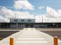
Whitsunday Airport (Shute Harbour) (IATA: WSY, ICAO: YSHR) is located in Flametree in the Whitsunday Region, Queensland, Australia. It is located between...
3 KB (151 words) - 12:57, 9 January 2024
Whitsunday Coast Airport (IATA: PPP, ICAO: YBPN), also known as Proserpine Airport, is located in Gunyarra, Queensland, Australia, 14 kilometres (8.7 mi)...
10 KB (684 words) - 07:41, 1 September 2024
in Queensland Whitsunday Islands National Park in Queensland Whitsunday Island, the largest of the Whitsunday Islands Whitsunday Region, a local government...
957 bytes (152 words) - 23:57, 12 November 2019

Bowen, Queensland (category Whitsunday Region)
(secondary coordinates) Bowen is a coastal town and locality in the Whitsunday Region, Queensland, Australia. In the 2021 census, the locality of Bowen...
55 KB (5,511 words) - 03:43, 1 September 2024

Cannonvale, Queensland (category Whitsunday Region)
GPX (secondary coordinates) Cannonvale is a coastal locality in the Whitsunday Region, Queensland, Australia. In the 2021 census, Cannonvale had a population...
23 KB (1,924 words) - 16:44, 25 July 2024

The Shire of Whitsunday was a local government area located in the North Queensland region of Queensland, Australia. The shire, administered from the...
6 KB (243 words) - 05:09, 24 January 2021

Proserpine, Queensland (category Whitsunday Region)
coordinates) Proserpine (/ˈprɒsərpaɪn/) is a rural town and locality in the Whitsunday Region, Queensland, Australia. In the 2021 census, the locality of Proserpine...
24 KB (1,955 words) - 04:56, 16 August 2024

Shute Harbour (category Whitsunday Region)
harbour in the Whitsunday Region of Queensland, Australia. It has port facilities and transport options for people seeking to access the Whitsunday Islands and...
11 KB (918 words) - 18:06, 25 July 2024
held) Mundingburra (ALP held) Thuringowa (ALP held) Townsville (ALP held) Whitsunday (LNP held) Barron River (ALP held) Cairns (ALP held) Cook (ALP held) Hill...
17 KB (1,323 words) - 22:17, 2 August 2024

Torres Strait Islands, Whitsunday Islands and South West Queensland. South East Queensland is commonly considered to be a single region. It contains two statistical...
13 KB (1,235 words) - 10:36, 5 January 2024
(Virginia) Conway, Washington Conway, Queensland, a locality in the Whitsunday Region, Queensland, Australia Conway River (New Zealand) Conway, Wales, now...
3 KB (363 words) - 17:48, 15 July 2022

Hayman Island (redirect from Hayman Island (Whitsunday Islands))
Hayman Island is the most northerly of the Whitsunday Islands, off the coast of Queensland, Australia. The island is 294 hectares (726 acres) and lies...
14 KB (1,004 words) - 07:47, 13 August 2024

Cyclone Ada (category Retired Australian region cyclones)
impacted the Whitsunday Region of Queensland, Australia, in January 1970. It has been described as a defining event in the history of the Whitsunday Islands...
32 KB (3,320 words) - 16:23, 8 May 2024

1879 until 2008, when it amalgamated with the Shire of Whitsunday to form the Whitsunday Region. The Shire's economy was based on tropical agriculture...
6 KB (448 words) - 05:09, 23 May 2021
Sugarloaf is a rural locality in the Whitsunday Region, Queensland, Australia. In the 2021 census, Sugarloaf had a population of 310 people. In the 2016...
3 KB (92 words) - 08:13, 30 May 2024

precisely defined. More generally, the area is known as the Mackay–Whitsunday Region. Nicknames of Mackay include the Sugar capital, Alexandra and Macktown...
95 KB (8,692 words) - 12:38, 1 September 2024

Hamilton Island (Queensland) (category Whitsunday Islands)
Hamilton Island is an island of the Whitsunday Islands in Queensland, Australia. It is approximately 887 kilometres (551 mi) north of Brisbane and 512...
18 KB (1,313 words) - 06:30, 22 June 2024
The Whitsunday Solar Farm is a solar farm located at Collinsville in North Queensland, Australia. It has a generating capacity of 57.5 megawatts. Operations...
1 KB (122 words) - 17:21, 9 November 2023
Collinsville: Australia Collinsville, Queensland, a rural town in the Whitsunday Region Collinsville, South Australia, a locality. Collinsville Station, a...
652 bytes (97 words) - 02:17, 12 September 2021
South Wales, a village Breadalbane, Queensland, a locality in the Whitsunday Region Breadalbane, Tasmania, a town Breadalbane, a community within the...
647 bytes (100 words) - 17:19, 6 August 2023

heritage-listed former mine at Station Street and Second Avenue, Scottville, Whitsunday Region, Queensland, Australia. It was established in 1919. It is also known...
29 KB (4,431 words) - 06:13, 20 November 2019
Kelsey Creek, Queensland (category Whitsunday Region)
Kelsey Creek is a rural locality in the Whitsunday Region, Queensland, Australia. In the 2021 census, Kelsey Creek had a population of 157 people. Kelsey...
8 KB (565 words) - 22:46, 31 August 2024

tourists, especially in the Whitsunday Islands and Cairns regions. Tourism is an important economic activity for the region, generating over AUD$3 billion...
119 KB (11,647 words) - 07:21, 14 August 2024

Collinsville, Queensland (category Whitsunday Region)
(secondary coordinates) Collinsville is a rural town and locality in the Whitsunday Region, Queensland, Australia. In the 2021 census, the locality of Collinsville...
22 KB (1,678 words) - 17:40, 3 August 2024
also refer to: Mandalay, Queensland, a locality in the Whitsunday Region, Australia Mandalay Region, an administrative division of Myanmar Mandalay, Mitchells...
1 KB (215 words) - 04:05, 25 June 2024

Burdekin Falls Dam (category Whitsunday Region)
called Lake Dalrymple, and is on the boundary of the Whitsunday Region and the Charters Towers Region. Burdekin Falls Dam is managed by SunWater. Water from...
11 KB (887 words) - 00:37, 4 January 2024