
State Trunk Highway 162 (often called Highway 162, STH-162 or WIS 162) is a state highway in the U.S. state of Wisconsin. It runs in north–south in southwest...
6 KB (275 words) - 07:45, 12 September 2023
Market Road 162 Utah State Route 162 Virginia State Route 162 Washington State Route 162 Wisconsin Highway 162 Territories Puerto Rico Highway 162 This article...
3 KB (196 words) - 23:31, 4 April 2024

Highway 12 Highway 16 (Wisconsin) Highway 21 (Wisconsin) Highway 27 (Wisconsin) Highway 33 (Wisconsin) Highway 71 (Wisconsin) Highway 131 (Wisconsin)...
18 KB (1,138 words) - 18:49, 18 September 2024

S. Highway 14 U.S. Highway 53 U.S. Highway 61 Highway 16 (Wisconsin) Highway 33 (Wisconsin) Highway 35 (Wisconsin) Highway 108 (Wisconsin) Highway 157...
23 KB (1,417 words) - 22:06, 3 September 2024

82 (Wisconsin) Highway 131 (Wisconsin) Highway 162 (Wisconsin) BNSF Scenic Mississippi Regional Transit List of intercity bus stops in Wisconsin Viroqua...
20 KB (1,324 words) - 22:07, 3 September 2024

La Crosse–Onalaska (category La Crosse, Wisconsin)
(Wisconsin) Highway 82 (Wisconsin) Highway 108 (Wisconsin) Highway 131 (Wisconsin) Highway 157 (Wisconsin) Highway 162 (Wisconsin) La Crosse MTU Scenic Mississippi...
11 KB (406 words) - 03:17, 7 October 2024

State Trunk Highway 16 (often called Highway 16, STH-16 or WIS 16) is a Wisconsin state highway running from Pewaukee across the state to La Crosse. Much...
31 KB (1,706 words) - 13:06, 20 August 2023

Vernon County, Wisconsin, United States. The population was 758 at the 2020 census. Coon Valley was hit by the floods ravaging Wisconsin in 2018. Coon...
12 KB (1,046 words) - 04:51, 23 August 2024

U.S. Route 53 (redirect from U.S. Highway 53 (Wisconsin))
Route 53, or U.S. Highway 53 (U.S. 53), is a north–south U.S. highway that runs for 404 miles (650 km) from La Crosse, Wisconsin to International Falls...
35 KB (2,265 words) - 14:27, 25 September 2024

U.S. Route 151 (redirect from U.S. Highway 151 (Wisconsin))
U.S. Highway 151 (US 151) is a United States Numbered Highway that runs through the states of Iowa and Wisconsin. The southern terminus for US 151 is...
40 KB (2,406 words) - 03:56, 28 July 2024

organized system of Wisconsin State Trunk Highways (typically abbreviated as STH or WIS), the state highway system for the U.S. state of Wisconsin, was created...
99 KB (275 words) - 17:48, 14 July 2024

State Trunk Highway 33 (often called Highway 33, STH-33 or WIS 33) is a Wisconsin state highway running east–west across central Wisconsin. It is 200.84...
14 KB (829 words) - 23:28, 27 July 2024
State Trunk Highway 35 (STH-35, WIS 35) is a Wisconsin state highway running north–south across western Wisconsin. It is 412.15 miles in length, and is...
38 KB (2,924 words) - 03:07, 25 July 2024

State Trunk Highway 29 (often called Highway 29, STH-29 or WIS 29) is a state highway running east–west across central Wisconsin. It is a major east–west...
31 KB (1,767 words) - 01:49, 5 August 2024

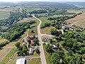
Monroe County, Wisconsin, United States. Four Corners is located at the junction of Wisconsin Highway 71 and Wisconsin Highway 162 6 miles (9.7 km)...
3 KB (86 words) - 04:48, 17 July 2023

State Trunk Highway 32 (often called Highway 32, STH-32 or WIS 32) is a state highway in the U.S. state of Wisconsin that runs north–south in the eastern...
27 KB (1,603 words) - 23:27, 27 July 2024

State Trunk Highway 163 (often called Highway 163, STH-163 or WIS 163) was a state highway in the U.S. state of Wisconsin. It ran north–south between...
3 KB (438 words) - 17:23, 16 February 2024
unincorporated community in the town of Washington in La Crosse County, Wisconsin, United States. "Middle Ridge". Geographic Names Information System. United...
3 KB (74 words) - 05:22, 27 July 2023

Interstate 39 (redirect from Interstate 39 (Wisconsin))
interchange four miles (6.4 km) further north near Poynette. The highway crosses the Wisconsin River four miles (6.4 km) north of CTH-CS. At three miles (4...
43 KB (2,675 words) - 17:05, 11 October 2024

Archives. State Highway Commission of Wisconsin (1960). Wisconsin Highway Map (PDF) (Map). 1:887,040. Madison: State Highway Commission of Wisconsin. Retrieved...
15 KB (922 words) - 09:49, 11 September 2024

Interstate 41 (redirect from Interstate 41 (Wisconsin))
north–south Interstate Highway connecting the interchange of I-94 and U.S. Route 41 (US 41), located about a mile (1.6 km) south of the Wisconsin–Illinois border...
37 KB (1,615 words) - 07:18, 11 September 2024

U.S. Route 10 (redirect from U.S. Highway 12 (Wisconsin 1925))
between Ludington, Michigan, and Manitowoc, Wisconsin, was officially designated as part of the highway. The ferry operates only between May and October...
20 KB (1,878 words) - 20:23, 8 October 2024

U.S. Highway 41 (US 41) is a north–south highway United States Numbered Highway in eastern Wisconsin. It runs from Pleasant Prairie on the Illinois border...
30 KB (1,177 words) - 03:28, 4 April 2024

After roughly 3.0 more miles (4.8 km) the highway reaches its junction with the northern end of WIS 162 in the unincorporated community of Four Corners...
18 KB (1,730 words) - 18:24, 27 April 2024

snack brand Jack Link's originated in Minong in 1986. U.S. Highway 53 and Wisconsin Highway 77 are two of the main routes in the community. Minong is located...
11 KB (1,050 words) - 02:26, 17 May 2024

Waupaca counties in the central part of the US state of Wisconsin. It runs in east–west from US Highway 10 (US 10) northwest of Amherst Junction via Iola to...
5 KB (562 words) - 17:22, 16 February 2024

Interstate 43 (redirect from Highway 15 (Wisconsin 1933))
Interstate Highway located entirely within the US state of Wisconsin, connecting I-39/I-90 in Beloit with Milwaukee and I-41, U.S. Highway 41 (US 41)...
58 KB (4,278 words) - 07:19, 11 September 2024

U.S. Highway 14 (US 14) in the state of Wisconsin runs northwest–southeast across the western to southwest portions of the state. It links La Crosse and...
22 KB (1,127 words) - 21:45, 8 July 2024

Fairchild is a village in Eau Claire County, Wisconsin, United States. The population was 550 at the 2010 census. The village is located within the Town...
12 KB (940 words) - 23:10, 18 September 2024

flowed east through this segment. Native Americans had long used the Wisconsin as a highway through the forests, canoeing and fishing it, living along its banks...
40 KB (4,209 words) - 03:47, 14 October 2024