
Wyodak is an unincorporated community in east-central Campbell County, Wyoming, United States. Wyodak began circa 1925 and existed to house Wyodak Coal...
4 KB (105 words) - 06:09, 27 July 2023

The Wyodak mine is a coal mine in Wyodak, Wyoming, United States, located about 6 miles (9.7 km) east of Gillette in the coal-rich Powder River Basin...
6 KB (481 words) - 01:11, 20 September 2024

Black Hills Corporation (redirect from Wyodak Resources Development)
wholesale energy wing. The centerpiece of the operation is the Wyodak Mine near Gillette, Wyoming in the Powder River Basin, which is the oldest operating surface...
13 KB (1,275 words) - 05:26, 15 April 2024

PacifiCorp (section Wyoming)
a regulated electric utility with service territory throughout Utah, Wyoming, and southeastern Idaho. PacifiCorp operates one of the largest privately...
17 KB (1,430 words) - 16:55, 7 September 2024
2020-06-07. "Wyodak Power Plant". Global Energy Monitor. Retrieved 2021-05-08. "Wyodak Mine". Global Energy Monitor. Retrieved 2021-05-08. "Wyoming Distributed...
29 KB (1,164 words) - 21:00, 18 May 2024

Justice Communities Map". energyjustice.net. Retrieved October 10, 2020. "Wyodak Power Plant". Global Energy Monitor. July 11, 2020. Retrieved September...
174 KB (6,864 words) - 19:38, 26 September 2024

Tongue River (Montana) (redirect from Tongue River (Wyoming))
2012-02-12. Retrieved 2009-02-15. "Wyodak Coal, Tongue River Member of the Fort Union Formation, Powder River Basin, Wyoming, Mark Ashley, 2005". Archived...
67 KB (9,062 words) - 00:04, 5 September 2024

the communities of Wyodak and Rozet, south of the Campbell County fairgrounds [1], coal mines, and south of Wyodak power plant. Wyoming 51 is the old alignment...
5 KB (279 words) - 17:45, 24 June 2023
plants in Wyoming: the Jim Bridger plant near Rock Springs, the Dave Johnston plant near Glenrock, the Naughton plant at Kemmerer or the Wyodak plant near...
23 KB (2,316 words) - 06:18, 9 October 2024
Alberta): 148 § Viropa, West Virginia (Virginia, Ohio, Pennsylvania): 650 Wyodak, Wyoming (Wyoming and South Dakota): 443 Most here are blends of two personal names...
100 KB (9,117 words) - 23:22, 18 September 2024
U.S. Highway 14 U.S. Highway 16 Wyoming Highway 50 Wyoming Highway 51 Wyoming Highway 59 Wyoming Highway 387 Wyoming Highway 450 Jefferson Lines Thunder...
16 KB (1,284 words) - 17:22, 29 September 2024
Barstow, California K30MW-D in Sweetgrass, etc., Montana K30MX-D in Wyodak, Wyoming K30NY-D in Victorville, etc., California K30OA-D in Milton-Freewater...
10 KB (1,399 words) - 02:19, 17 September 2024
of broadcast television stations that are licensed in the U.S. state of Wyoming. VC refers to the station's PSIP virtual channel. RF refers to the station's...
22 KB (67 words) - 07:25, 13 May 2024

Interstate 90 (I-90) in the US state of Wyoming traverses the northeastern corner of the state, passing through the cities and communities of Sheridan...
21 KB (1,487 words) - 16:28, 19 August 2024
in Garfield County, Utah K30GV-D in Shoshoni, Wyoming K30KC-D in Samak, Utah K30MX-D in Wyodak, Wyoming K30PQ-D in Clear Creek, Utah K31JE-D in Escalante...
8 KB (1,113 words) - 16:59, 2 August 2024

the original on 2009-04-17. Retrieved 2009-04-21. "Wyodak Resources Development Home Page". Wyodak website. Black Hills Corporation. Retrieved 2009-04-21...
10 KB (336 words) - 00:54, 9 May 2023

U.S. Highway 14 (US 14) in the U.S. state of Wyoming runs east to west across the northern part of the state. The road connects South Dakota on the east...
14 KB (814 words) - 17:05, 20 May 2024
Barstow, California K30MW-D in Sweetgrass, etc., Montana K30MX-D in Wyodak, Wyoming K30NY-D in Victorville, etc., California, on virtual channel 30 K30OA-D...
13 KB (1,817 words) - 00:12, 26 April 2024

geologic member of the Fort Union Formation in Montana, North Dakota, Wyoming. The strata are yellow or light-colored massive sandstones and numerous...
2 KB (182 words) - 21:53, 15 March 2024
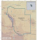
Powder River Basin (category Geology of Wyoming)
(Black Thunder Mine, Coal Creek Mine) Black Hills Corporation/Wyodak Resources Development (Wyodak Mine) Contura Energy (Belle Ayr Mine, Eagle Butte Mine) Navajo...
29 KB (3,356 words) - 04:39, 4 October 2024
Project Thunderbird (category 1968 in Wyoming)
Union-Wasatch Formation. The Roland coalbed, which was being surface mined at the Wyodak Mine 25 miles (40 km) to the east, lies at depths of 1,000 feet (300 m)...
7 KB (870 words) - 12:11, 6 October 2024
F2 or stronger. F1 NNE of Wyodak (1st tornado) Campbell WY 44°18′N 105°22′W / 44.30°N 105.37°W / 44.30; -105.37 (Wyodak #1 (June 3, F1)) 00:35–? 1...
34 KB (1,849 words) - 14:15, 7 June 2024
the North Antelope and Rochelle mines in the low sulfur Wyodak seam in the heart of Wyoming's Powder River Basin in 1983 and 1984, respectively. The passage...
48 KB (4,610 words) - 15:28, 3 October 2024
KGWC-TV (category 1980 establishments in Wyoming)
KGWC-TV (channel 14) is a television station in Casper, Wyoming, United States, affiliated with CBS. It is owned by Big Horn Television LLC, which maintains...
36 KB (2,963 words) - 01:27, 10 August 2024

Fort Union Formation (category Geologic formations of Wyoming)
total more than 300 feet in thickness. One such bed, the Wyodak Coal near Gillette, Wyoming, is as much as 110 feet (34 m) thick. Most of the coals in...
50 KB (1,560 words) - 23:28, 16 July 2024
part of a four-day event which produced a total of 125 tornadoes from Wyoming to Minnesota from June 21 to June 24. While there were no fatalities on...
33 KB (97 words) - 20:02, 9 February 2024
Belle Ayr Mine (category Mines in Campbell County, Wyoming)
and shovel", mine producing a low-sulfur, sub-bituminous coal from the Wyodak-Anderson seam that is used for domestic energy generation. Coal produced...
8 KB (612 words) - 01:10, 20 September 2024
licensed, formerly broadcast on digital or analog channel 8: K08AA in Wyodak, etc., Wyoming K08AS in Henefer, etc., Utah K08AU in Spring Glen, etc., Utah K08AX-D...
6 KB (844 words) - 16:59, 2 August 2024