
York is the oldest inland town in Western Australia, situated on the Avon River, 97 kilometres (60 mi) east of Perth in the Wheatbelt, on Ballardong Nyoongar...
50 KB (5,084 words) - 16:14, 24 August 2024

Western Australia (WA) is a state of Australia occupying the western third of the land area of the Australian continent.[text–source integrity?][citation...
90 KB (8,282 words) - 17:43, 1 September 2024

The Wheatbelt is one of nine regions of Western Australia defined as administrative areas for the state's regional development, and a vernacular term...
18 KB (1,526 words) - 04:20, 1 May 2024
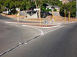
York Road (currently known in parts as the Old York Road) was the main road connecting Guildford and York, in Western Australia, during the 19th and 20th...
4 KB (480 words) - 20:22, 12 February 2023

north-north-east of Perth, in the Hamersley Range in the Pilbara region of Western Australia. The declared contaminated site comprises 50,000 hectares (120,000...
30 KB (2,732 words) - 20:16, 8 September 2024

The Uniting Church, York is a Uniting church located in Grey Street, York, Western Australia. The church building was established by the Methodist Church...
15 KB (1,869 words) - 12:40, 19 October 2023
history of Western Australia commenced "over 50,000 years ago and possibly as much as 70,000 years ago" with the arrival of Aboriginal Australians on the...
53 KB (6,382 words) - 14:36, 28 August 2024
Wara art (section Wara art in York, Western Australia)
endangered Australian animals, designed by Professor Miyajima, have also been created in York, Western Australia as part of the annual York Festival. There...
2 KB (255 words) - 06:38, 28 January 2021

Kinjarling) is a port city in the Great Southern region in the Australian state of Western Australia, 418 kilometres (260 mi) southeast of Perth, the state capital...
46 KB (3,839 words) - 11:03, 30 August 2024

York railway station is a disused station on the Eastern Railway in Western Australia. It is located in the town of York. The York station opened on 29...
9 KB (1,034 words) - 05:49, 1 May 2024

Anglican church on the corner of Newcastle and Pool Streets, in York, Western Australia. The church was consecrated in 1858 by the first Anglican Bishop...
14 KB (1,241 words) - 21:05, 3 April 2024

The Western Australian Bank building in York is the third oldest surviving bank building in Western Australia and, until 27 September 2019, was the oldest...
4 KB (236 words) - 15:10, 8 February 2023

Secessionism has been a recurring feature of Western Australia's political landscape since shortly after Federation in 1901. The idea of self-governance...
31 KB (3,200 words) - 22:35, 19 January 2024

for the Shire of Shark Bay, Western Australia. At the 2016 census, Denham had a population of 754. Located on the western coast of the Peron Peninsula...
12 KB (975 words) - 15:01, 13 March 2024

Merredin /ˈmɛrədɪn/ is a town in Western Australia, located in the central Wheatbelt roughly midway between Perth and Kalgoorlie, on Route 94, Great Eastern...
16 KB (1,826 words) - 02:24, 24 July 2024
Cape York Peninsula, Queensland, previously York Cape York, Western Australia Shire of York, Western Australia Yorke Peninsula (disambiguation), articles...
5 KB (642 words) - 20:25, 21 August 2024

Northam is a town in the Wheatbelt region of Western Australia, situated at the confluence of the Avon and Mortlock Rivers. It is the largest town and...
40 KB (3,747 words) - 07:58, 8 September 2024

The Western Australian economy is a state economy dominated by its resources and services sector and largely driven by the export of iron-ore, gold, liquefied...
27 KB (3,080 words) - 18:33, 22 December 2023
The Kimberley is the northernmost of the nine regions of Western Australia. It is bordered on the west by the Indian Ocean, on the north by the Timor...
54 KB (5,265 words) - 01:55, 15 July 2024

York County was one of the 26 counties of Western Australia that were designated in 1829 as cadastral divisions. It was named after Prince Frederick,...
1,021 bytes (104 words) - 10:25, 21 January 2021

colloquially called Dally, is a town in the Wheatbelt region of Western Australia, located 248 km from Perth via the Great Northern Highway. Agriculture...
9 KB (512 words) - 07:53, 25 August 2024
Campion is an abandoned townsite in the Wheatbelt region of Western Australia, located in the Shire of Nungarin on the Koorda–Bullfinch Road. It is situated...
7 KB (665 words) - 14:52, 30 August 2024
John Henry Monger Snr (category People from York, Western Australia)
John Henry Monger Snr (1802–1867) arrived in Western Australia as an assisted migrant in 1829. After a short period running a mill at what became Lake...
27 KB (4,476 words) - 02:24, 9 July 2023

Wagin /ˈweɪdʒɪn/ is a town and shire in the Wheatbelt region of Western Australia, approximately 225 km (139.81 mi) south-east of Perth on the Great Southern...
14 KB (1,217 words) - 12:33, 1 August 2024

and 1910, is a town on the Avon River in the Wheatbelt region of Western Australia, 85 kilometres (53 mi) north-east of Perth. The first European settlement...
26 KB (2,539 words) - 00:35, 25 August 2024
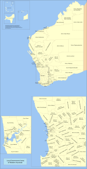
There are 137 local government areas (LGAs) in Western Australia, which comprise 27 cities, 102 shires, and 8 towns that manage their own affairs to the...
59 KB (1,456 words) - 23:12, 21 June 2024
Over 1400 ships have been wrecked on the coast of Western Australia. This relatively large number of shipwrecks is due to a number of factors, including:...
21 KB (2,555 words) - 02:59, 30 August 2024

Ardath is a small town in the Wheatbelt region of Western Australia 20 kilometres (12 mi) south of the town of Bruce Rock. It was built to serve the Corrigin...
3 KB (315 words) - 01:16, 28 July 2024

kilometres (97 mi) north-east of Perth in the central Wheatbelt region of Western Australia. It is the seat of the Shire of Dowerin. In 1906 the government extended...
7 KB (796 words) - 10:23, 26 August 2024

hinterland of Western Australia. Ensign Robert Dale reached the summit on 18 October 1829. John Septimus Roe communicated with Dale over the York Road he had...
11 KB (1,257 words) - 16:09, 24 August 2024