
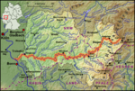
Rothaar Mountains (redirect from Rothaargebirge)
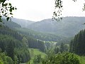
The Rothaar Mountains (German: Rothaargebirge, pronounced [ˈʁoːthaːɐ̯ɡəˌbɪʁɡə] , also Rotlagergebirge), or Rothaar, is a low mountain range reaching heights...
7 KB (605 words) - 15:30, 20 August 2024

6 km), and Rhineland-Palatinate (57.0 km). It has its source in the Rothaargebirge, the highest part of the Sauerland. It meets the Rhine at Lahnstein...
35 KB (3,791 words) - 22:22, 4 June 2024

as well as the left-Rhenish Eifel in the southwest of the state. The Rothaargebirge in the border region with Hesse rises to height of about 800 m above...
68 KB (5,621 words) - 20:16, 27 September 2024
Bremberg (Rothaar) (redirect from Bremberg (Rothaargebirge))
8°29′43″E / 51.1895667°N 8.4951528°E / 51.1895667; 8.4951528 Geography Location Sauerland, North Rhine-Westphalia, Germany Parent range Rothaargebirge...
2 KB (146 words) - 20:12, 14 November 2022
Hohe Warte (Rothaar) (redirect from Hohe Warte (Rothaargebirge))
Germany. The Hohe Warte rises as part of the eastern slope of the Rothaargebirge in the Elbrighäuser Forest, which belongs to the Ederbergland hinterland...
4 KB (500 words) - 11:45, 27 May 2024
It is 155 kilometres (96 mi) in length. The source is located in the Rothaargebirge mountains. From here the river runs southwestwards to the city of Siegen...
3 KB (262 words) - 22:31, 4 June 2024
Map of the Lahn river from its source in the Rothaargebirge to its mouth near Koblenz...
18 KB (2,542 words) - 09:06, 15 September 2023

Rothaarsteig is a 154.80 km long hiking trail along the crest of the Rothaargebirge mountain range in Germany in the border region between the states of...
14 KB (1,682 words) - 09:08, 15 September 2023

forest might not cover all of the protected area. "Naturpark Sauerland Rothaargebirge" (in German). Retrieved 11 September 2019. "Le Parc naturel des deux...
15 KB (556 words) - 15:41, 3 August 2024
November 2018. Kerber, Malte (12 July 2017). Eine Wanderung über das Rothaargebirge und durch den Westerwald: Notizenbuch. Engelsdorfer Verlag. ISBN 9783961451395...
7 KB (408 words) - 16:25, 6 October 2024
This is a list of ski areas and resorts in Europe. Dardhë Pukë Grandvalira-Soldeu Grandvalira-El Tarter Grandvalira-Grau Roig Grandvalira - Pas de la Casa...
55 KB (5,761 words) - 00:25, 19 July 2024

Langenberg (Rothaar) (redirect from Langenberg (Rothaargebirge))
The Langenberg (German pronunciation: [ˈlaŋənˌbɛʁk] ) rises on the state border between North Rhine-Westphalia and Hesse in Germany and, at 843.2 m above sea...
5 KB (543 words) - 20:13, 20 August 2024

municipality's area is roughly 41 km². West of the community lies the Rothaargebirge, a low mountain range. The municipal area is bounded on the east by...
4 KB (299 words) - 09:32, 6 July 2023
near Winterberg. Both Langenberg and Kahler Asten are peaks in the Rothaargebirge mountains. The Sauerland has six reservoir lakes. Sorpesee Biggesee...
11 KB (1,265 words) - 08:06, 20 August 2024

Dill the Westerwald begins; north of the Lahn and east of the Dill the Rothaargebirge begin. The highest point within town limits is the Stoppelberg at 401 m...
41 KB (5,253 words) - 17:03, 25 September 2024
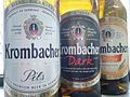
Rhine-Westphalia. The small town of Krombach is located at the foot of the Rothaargebirge. Krombacher Brewery produces the second most consumed Pilsener in Germany...
8 KB (821 words) - 14:45, 20 August 2024

covered in coppice. To the north lies the Sauerland, to the northwest the Rothaargebirge and to the southwest the Westerwald. The nearest cities to Siegen, taking...
53 KB (6,014 words) - 13:51, 20 August 2024

the east also belongs, on the southern edge of the Sauerland and the Rothaargebirge. Lying between 320 and 650 m above sea level, the town is also crossed...
11 KB (1,088 words) - 01:07, 14 March 2024

Westerwaldkreis and partly in Siegen-Wittgenstein. It is found south of the Rothaargebirge, southwest of the Lahn-Dill-Bergland (another low mountain range), north...
30 KB (3,393 words) - 23:40, 29 August 2024

the Rhine, the Siebengebirge mountain range and even as far as the Rothaargebirge mountain range. This iron ore mining tunnel known as the Amiger tunnel...
20 KB (2,346 words) - 14:22, 21 September 2024

The second highest mountain of the Sauerland, the Kahler Asten in the Rothaargebirge, is located in the city area, which also contains the spring of the...
10 KB (950 words) - 14:14, 8 July 2024

and to the Bollerberg, a mountain belonging to the mountain range of Rothaargebirge. It is 7 km far from Bromskirchen, a municipality in the bordering state...
2 KB (158 words) - 01:36, 25 October 2020

natural region of Langenberg, which contains the highest peak in the Rothaargebirge, the 843,1 m high Langenberg, as well as other summits over 800 m high...
8 KB (699 words) - 21:12, 2 August 2024
the Taunus in the south, the Lahn-Dill-Bergland in the east and the Rothaargebirge of the Sauerland in the north. The highest elevation with 671 m (2,201 ft)...
6 KB (738 words) - 08:08, 3 August 2024

annually. The Kahler Asten is located in the northwestern part of the Rothaargebirge in the Hochsauerland region, a little southwest of Winterberg between...
13 KB (1,247 words) - 20:13, 20 August 2024
(Rothaar), the highest mountain in northwestern Germany, located in the Rothaargebirge mountains Langenberg (Rhineland), an independent town until 1975, now...
1 KB (163 words) - 15:11, 25 April 2024
Mountains, hills or woodlands in Germany: Hülsenberg (607 m), in the Rothaargebirge in the state of North Rhine-Westphalia Hülsenberg (573 m), north of...
820 bytes (140 words) - 17:03, 14 September 2013

of Germany. It is located on the east side of the heavily forested Rothaargebirge (Red-haired Mountains), immediately on the border with Hesse. There...
5 KB (243 words) - 03:25, 30 May 2024

Berleburg lies in the northeast of Siegen-Wittgenstein in the middle of the Rothaargebirge, a low mountain range. The western town limit is also the boundary with...
13 KB (1,455 words) - 15:03, 20 August 2024
Haincher Höhe (heights that reach 606 m), where the mountain ranges Rothaargebirge and Westerwald meet. During its course, roughly from north to south...
3 KB (205 words) - 17:56, 18 April 2020