of the former state routes in Arizona, including mileage tables and maps. Between the establishment of Arizona's numbered state highway system in 1927 and...
93 KB (8,974 words) - 00:23, 10 July 2024
state of Arizona's State Routes are usually abbreviated as SR. The Arizona State Highway system was introduced on September 9, 1927, by the State Highway...
50 KB (1,442 words) - 13:32, 15 August 2023

State Route 89 (SR 89) is a 104.53-mile (168.22 km) state highway in the U.S. state of Arizona. It is part of the former route of U.S. Route 89 (US 89)...
5 KB (254 words) - 04:36, 19 March 2024
State Route 30 (formerly State Route 801), also known as the I-10 Reliever, is a planned state highway in the southwest parts of Phoenix, Arizona and nearby...
17 KB (1,572 words) - 17:24, 3 May 2024

State Route 80 (SR 80) is a 120.20-mile (193.44-kilometre) long, roughly arc-shaped highway lying in southeastern Arizona. Starting in downtown Benson...
15 KB (1,581 words) - 22:09, 25 June 2023

State Route 95, also known as SR 95, is a north–south state highway along the western edge of Arizona that is split into two sections. The southern segment...
10 KB (574 words) - 10:33, 29 March 2024

State Route 79 (SR 79), also known as the Pinal Pioneer Parkway, is a 58.40 mi (93.99 km) long state highway in the U.S. state of Arizona. It serves as...
19 KB (1,926 words) - 21:22, 27 June 2023

State Route 64 (SR 64) is a 108.31-mile-long (174.31 km) state highway in the northern part of the US state of Arizona. It travels from its western terminus...
8 KB (669 words) - 01:59, 9 July 2023

State Route 66 (SR 66) is a surface road in the U.S. state of Arizona in Mohave and Coconino Counties. In 1914, the road was designated "National Old...
7 KB (550 words) - 18:00, 24 March 2024

State Route 89A (SR 89A) is an 83.85-mile (134.94 km) state highway that runs from Prescott north to Flagstaff in the U.S. state of Arizona. The highway...
27 KB (2,115 words) - 20:08, 19 December 2023

Arizona State Route 202 (SR 202) or Loop 202 (202L) is a semi-beltway circling the eastern and southern areas of the Phoenix metropolitan area in central...
45 KB (3,333 words) - 20:50, 24 May 2024

Arizona State Route 101 (SR 101) or Loop 101 is a semi-beltway looping around the Phoenix Metropolitan Area in central Arizona, United States. It connects...
25 KB (1,732 words) - 02:40, 6 February 2024

State Route 88 is a long state highway in the U.S. state of Arizona. It runs from U.S. Route 60 (US 60) in Apache Junction through desert terrain to SR...
13 KB (1,127 words) - 16:08, 29 November 2023

U.S. Route 66 (US 66, Route 66) also known as the Will Rogers Highway, was a major United States Numbered Highway in the state of Arizona from November...
149 KB (16,039 words) - 05:08, 17 May 2024

westward, the business routes often follow the historic alignment of the former U.S. Route 66 (US 66). Interstate business routes in California are assigned...
81 KB (7,386 words) - 16:08, 14 April 2024

Arizona (/ˌærɪˈzoʊnə/ ARR-ih-ZOH-nə; Navajo: Hoozdo Hahoodzo [hoː˥z̥to˩ ha˩hoː˩tso˩]; O'odham: Alĭ ṣonak [ˈaɭi̥ ˈʂɔnak]) is a landlocked state in the...
162 KB (13,722 words) - 22:38, 13 July 2024

280 and U.S. Route 380 are sibling routes of US 180. Arizona State Route 180A serves as an alternate spur of US 180 in eastern Arizona. U.S. Roads portal...
16 KB (1,579 words) - 22:55, 30 May 2024

State Route 72 (SR 72) is a 36.74-mile-long (59.13 km) state highway in the U.S. state of Arizona. It runs from SR 95 near Parker southeast to U.S. Route...
9 KB (895 words) - 00:39, 10 November 2021

U.S. Route 191 (US 191) is a north–south U.S. Highway in eastern Arizona. The highway runs for 516.50 miles (831.23 km), making it Arizona's longest numbered...
47 KB (4,570 words) - 17:51, 15 April 2024

State Route 85 (SR 85) is a 128.86-mile-long (207.38 km) state highway in the U.S. state of Arizona. The highway runs from the United States–Mexico border...
20 KB (1,696 words) - 21:00, 23 March 2024

160 near Cortez, Colorado along the routes of State Route 14, U.S. Route 89, Arizona State Route 98, U.S. Route 160, the current US 163, the new road...
16 KB (1,629 words) - 10:18, 28 August 2023

Interstate 17 (redirect from Arizona State Route 79 (1950-1968))
entirely within the US state of Arizona. I-17's southern terminus lies in Phoenix, at I-10/US 60 and its northern terminus is in Flagstaff, at Milton Road...
26 KB (1,443 words) - 03:24, 6 June 2024

the former highway as Historic U.S. Route 80, making it the fourth state-recognized historic route in Arizona's history. Within the state of Arizona, US 80...
112 KB (12,533 words) - 14:49, 3 May 2024

U.S. Route 60 (US 60) is an east–west United States Highway within Arizona. The highway runs for 369 miles (594 km) from a junction with Interstate 10...
40 KB (2,441 words) - 21:49, 3 March 2024

Interstate 8 (redirect from Arizona State Route 8)
These were later replaced by U.S. Route 80 (US 80) across California and part of Arizona, and Arizona State Route 84 (SR 84) between Gila Bend and Casa...
111 KB (11,974 words) - 18:13, 28 May 2024

suburbs of Phoenix to planned ones in northwestern Pinal County. It is the lowest-numbered state route in Arizona. The first mile from Loop 202 to Ellsworth...
18 KB (1,667 words) - 06:35, 7 June 2024

Arizona State Route 51 (SR 51), also known as the Piestewa Freeway, is a numbered state highway in Phoenix, Arizona. It connects Interstate 10 and Loop...
15 KB (1,203 words) - 14:35, 3 July 2024

(26 km) toward Coolidge, passing by the town of Eloy. In Coolidge, State Route 87 is known as Arizona Boulevard. The highway leaves Coolidge heading northwest...
11 KB (642 words) - 20:53, 11 October 2022
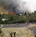
Yarnell Hill Fire (redirect from 2013 Arizona fire)
firefighter disaster in history, the deadliest wildfire ever in the state of Arizona, and (at least until 2014) was "the most-publicized event in wildland firefighting...
32 KB (3,426 words) - 23:01, 13 July 2024

Arizona State Route 74 (SR 74), locally known as the Carefree Highway, is a state highway in central Arizona that stretches east to west from its junction...
6 KB (727 words) - 17:33, 13 June 2023