
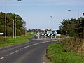
The A1198 is a road in Cambridgeshire, England, which runs between the A505 at Royston, and the A1307 on the outskirts of Huntingdon. Royston Kneesworth...
3 KB (248 words) - 23:22, 27 December 2023

renamed: most recent first, A1307, A14, A604, A132, Via Devana). The A1198 road, Ermine Street links traffic to the A14 or to Royston, and is used for...
27 KB (2,494 words) - 01:20, 20 August 2024
List of A roads in zone 1 in Great Britain beginning north of the River Thames, east of the A1 (roads beginning with 1). "Old Stoke Bridge, Ipswich"....
99 KB (79 words) - 09:30, 3 September 2024

A roads in zone 6 in Great Britain starting east of the A6 and A7 roads, and west of the A1 (road beginning with 6). "A613 (Gateshead)". sabre-roads.org...
47 KB (86 words) - 12:39, 16 July 2024
the Roman Ermine Street, now the A1198 road, bisects Caxton parish. The modern village has grown up around the road, although the church is a short distance...
9 KB (997 words) - 03:23, 20 August 2024

section of road between the A10 at Royston and the A1 at Alconbury, following part of the route of Ermine Street which is now designated the A1198 to Godmanchester...
57 KB (4,746 words) - 21:17, 28 August 2024
at 205 at the 2011 census. It is situated on the western side of the A1198 road (Ermine Street), running for about a mile along the B1046. Seventeen people...
9 KB (949 words) - 12:55, 15 March 2023

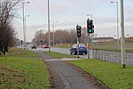
when the A14 opened. It meets the A1198 (former A14) at Caxton Gibbet roundabout near Papworth Everard. From here the road is dual carriageway, bypassing...
13 KB (1,167 words) - 15:52, 7 September 2024

of Wendy and Bassingbourn immediately to the west of the A14 (now the A1198) road. The site selected was low ground between several tributaries of the...
34 KB (3,713 words) - 11:32, 18 February 2024
10 miles (16 km) south-west of Cambridge and immediately west of the A1198 road (the Roman Ermine Street). The population in 2001 was 221 people, increasing...
12 KB (1,253 words) - 05:41, 30 December 2023

are mostly west of the A1198 road, with the exception of a small area of land to the east, next to Wimpole Park. A minor road runs west to Croydon; the...
7 KB (601 words) - 14:42, 11 August 2024

Roman roads in Britannia were initially designed for military use, created by the Roman army during the nearly four centuries (AD 43–410) that Britannia...
39 KB (3,425 words) - 21:01, 15 February 2024

December 2014, planning would begin to dual the section between the A1 and the A1198 at Caxton Gibbet. The link is to provide an uninterrupted dual carriageway...
13 KB (1,293 words) - 23:31, 2 September 2024
B roads are numbered routes in Great Britain of lesser importance than A roads. See the article Great Britain road numbering scheme for the rationale behind...
86 KB (29 words) - 18:03, 16 July 2024

called Grove Road and for much of the distance after crossing Roman Road it forms the eastern boundary of Mile End Park. Where the road passes under the...
7 KB (690 words) - 02:46, 24 March 2024

station was located on the eastern side of the Old North Road, the A1198 road - a major Roman road which linked London with Lincoln. Opened in 1862, the...
4 KB (357 words) - 19:25, 24 March 2021
The A10 is a major road in England which runs between The City of London and King's Lynn in Norfolk. At its southern terminus, the route meets the A3 directly...
33 KB (1,834 words) - 06:37, 30 August 2024

The A11 is a major trunk road in England. It originally ran roughly north east from London to Norwich, Norfolk. It now consists of a short section in Inner...
21 KB (2,165 words) - 13:43, 6 August 2024
and Wear. The road runs from Simonside to Marsden via Harton Nook. It is 3.7 miles (6 km) long. The A1300 begins as the John Reid Road at the junction...
2 KB (245 words) - 20:37, 1 February 2024

The A12 is a major road in Eastern England. It runs north-east/south-west between London and the coastal town of Lowestoft in the north-eastern corner...
59 KB (4,279 words) - 06:35, 30 August 2024

The A135 is a road in England, running from Stockton-on-Tees through Eaglescliffe to Yarm on the A67, on the boundary with the River Tees. It is also known...
5 KB (126 words) - 15:59, 29 January 2024

The A16 road is a principal road of Lincolnshire in the East Midlands region of England, connecting the port of Grimsby and Peterborough, where it meets...
17 KB (1,051 words) - 11:12, 8 September 2023

The A118 is a road in east London, England which links Bow Interchange with Gallows Corner in Romford via Stratford and Ilford. The section from Bow Interchange...
4 KB (291 words) - 16:38, 18 December 2023

also known as the Southend Arterial Road, is a major road in Essex, England. It was constructed as a new arterial road project in the 1920s, linking Romford...
9 KB (1,111 words) - 11:07, 15 June 2024

The A18 is a road in England that links Doncaster in South Yorkshire with Ludborough in Lincolnshire, via Scunthorpe and Grimsby. Much of its route has...
15 KB (992 words) - 10:26, 27 August 2024

road in England running approximately parallel to and east of the A1 road. Although the two roads meet at the northern end of the A19, the two roads originally...
15 KB (1,882 words) - 06:43, 30 August 2024

The A167 and A167(M) is a road in North East England. It is partially a trunk road and partially a motorway, where it is commonly referred to as Newcastle...
8 KB (625 words) - 06:58, 29 August 2024

major road in North Yorkshire, and the unitary authority of Middlesbrough, England. It runs from Ingleby Arncliffe to Middlesbrough. The road derives...
5 KB (544 words) - 01:31, 22 September 2023

Rotherhithe Tunnel (redirect from A101 road)
The Rotherhithe Tunnel, designated the A101, is a road tunnel under the River Thames in East London, connecting Limehouse in the London Borough of Tower...
15 KB (2,138 words) - 05:49, 16 August 2024

A1198, a Royston to Huntingdon road which is in a perfect straight line, and serves part of the London – Lincoln Roman Road, Ermine Street. This road...
10 KB (1,288 words) - 14:37, 9 September 2024