
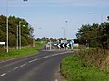
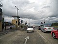
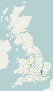
The A146 is an A road that connects Norwich in Norfolk and Lowestoft in Suffolk, two of East Anglia's largest population centres. It is around 27 miles...
9 KB (1,080 words) - 12:13, 7 December 2023

Beccles (section Beccles Southern Relief Road)
the north by the A146 road between Norwich in Norfolk and Lowestoft in Suffolk. The by-pass was built in the 1980s and the main road previously ran through...
25 KB (2,592 words) - 20:34, 6 September 2024

the town becoming a 'B' road. Beginning as Copland Way, the A145 has its northernmost point at a roundabout with the A146 road between Worlingham and North...
17 KB (1,861 words) - 17:54, 16 April 2022

A11 Bridge 3 railway bridges A140 Bridge 3 railway bridges River Tas A146 Road Bridge TrowseMills Limit of navigation River Wensum (to Norwich city centre)...
13 KB (1,623 words) - 06:43, 3 April 2024
List of A roads in zone 1 in Great Britain beginning north of the River Thames, east of the A1 (roads beginning with 1). "Old Stoke Bridge, Ipswich"....
99 KB (79 words) - 09:30, 3 September 2024

Australian implementation AS1744-1975 Standard Alphabets in the appendix pp A103-A146. Clearview appears to have supplanted it, and other fonts are in use. Regulatory...
28 KB (1,530 words) - 17:11, 29 July 2024

The A11 is a major trunk road in England. It originally ran roughly north east from London to Norwich, Norfolk. It now consists of a short section in Inner...
21 KB (2,165 words) - 13:43, 6 August 2024

The A167 and A167(M) is a road in North East England. It is partially a trunk road and partially a motorway, where it is commonly referred to as Newcastle...
8 KB (625 words) - 06:58, 29 August 2024

The A12 is a major road in Eastern England. It runs north-east/south-west between London and the coastal town of Lowestoft in the north-eastern corner...
59 KB (4,279 words) - 06:35, 30 August 2024

B roads are numbered routes in Great Britain of lesser importance than A roads. See the article Great Britain road numbering scheme for the rationale behind...
86 KB (29 words) - 18:03, 16 July 2024

major road in North Yorkshire, and the unitary authority of Middlesbrough, England. It runs from Ingleby Arncliffe to Middlesbrough. The road derives...
5 KB (544 words) - 01:31, 22 September 2023

church and its small smattering of houses is Wash Lane which leads to the A146 road (between Norwich and Beccles). The church is 12.4 miles (20.0 km) from...
4 KB (377 words) - 12:21, 8 December 2022

Great Eastern Main Line. It is crossed by Boudica's Way, then meets the A146 at a GSJ. It crosses the River Yare again at the Postwick Viaduct and enters...
42 KB (4,808 words) - 17:10, 7 September 2024

called Grove Road and for much of the distance after crossing Roman Road it forms the eastern boundary of Mile End Park. Where the road passes under the...
7 KB (690 words) - 02:46, 24 March 2024
centre, from the A146 (now A147) to the A47 (now A1242). It is now classified as parts of the A147 and A1242 inner ring road in the city. "Road traffic statistics...
5 KB (527 words) - 16:22, 27 October 2022
The A10 is a major road in England which runs between The City of London and King's Lynn in Norfolk. At its southern terminus, the route meets the A3 directly...
33 KB (1,834 words) - 06:37, 30 August 2024

The A140 is an 'A-class' road in Norfolk and Suffolk, East Anglia, England partly following the route of the Roman Pye Road. It runs from the A14 near...
11 KB (1,032 words) - 15:56, 16 April 2022

The A179 is the major link road between the A19 and Hartlepool via Hart Village. This road has a good view of the east Durham coast and the northern part...
1 KB (64 words) - 00:51, 16 May 2024

stands in open fields to the south of the village and to the east of the A146 road. St Margaret's was built in the 12th century and, other than the addition...
7 KB (643 words) - 07:42, 13 December 2023

The A118 is a road in east London, England which links Bow Interchange with Gallows Corner in Romford via Stratford and Ilford. The section from Bow Interchange...
4 KB (291 words) - 16:38, 18 December 2023

The A149 is commonly known as "The Coast Road" to local residents and tourists, as this road runs along the North Norfolk coast from King's Lynn to Great...
22 KB (3,147 words) - 12:36, 9 July 2024

The A168 is a major road in North Yorkshire, England. It runs from Northallerton to Wetherby, acting as a local access road for the A1(M). The majority...
8 KB (1,010 words) - 20:04, 1 June 2024
The A1, also known as the Great North Road, is the longest numbered road in the United Kingdom, at 410 miles (660 km). It connects London, the capital...
75 KB (4,362 words) - 16:05, 2 September 2024

village is bypassed to the south by the A146 road, with the A145 Beccles to Blythburgh road joining the A146 in the parish. Part of Beccles Airfield is...
11 KB (1,051 words) - 21:04, 10 November 2023

The A14 is a major trunk road in England, running 127 miles (204 km) from Catthorpe Interchange, a major intersection at the southern end of the M6 and...
57 KB (4,746 words) - 21:17, 28 August 2024

The A16 road is a principal road of Lincolnshire in the East Midlands region of England, connecting the port of Grimsby and Peterborough, where it meets...
17 KB (1,051 words) - 11:12, 8 September 2023

Gull Wing Bridge (section Reclassification of Roads)
stretch between Cotmer Road and Peto Way, encompassing Normanston Drive, Bridge Road and Saltwater Way, was reclassfied as the A146. The stretch covering...
21 KB (2,118 words) - 22:23, 9 September 2024

with the A146 at a roundabout a few miles from Beccles. During the summer months this is an area very popular with holiday makers so the road can be quite...
6 KB (581 words) - 18:06, 20 December 2023

First Eastern Counties service X2 also departs for Lowestoft, via the A146 road, calling at Loddon and Beccles. The travel centre contains a waiting area...
6 KB (539 words) - 05:13, 31 July 2024

The A17 road is a mostly single carriageway road linking Newark-on-Trent in Nottinghamshire, England, to King's Lynn in Norfolk. It stretches for a distance...
23 KB (2,431 words) - 20:05, 1 June 2024