Bukit Timah Road (Chinese: 武吉知马路; Malay: Jalan Bukit Timah; Tamil: புக்கித் திமா சாலை) is a major road in Singapore extending from the city centre to Woodlands...
5 KB (522 words) - 08:38, 12 December 2023

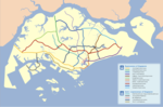
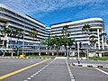
Bukit Timah, often abbreviated as Bt Timah, is a planning area and residential estate located in the westernmost part of the Central Region of Singapore...
14 KB (937 words) - 12:09, 1 June 2024

The Bukit Timah Expressway (BKE) is a highway in Singapore that starts at the Pan Island Expressway in Bukit Timah and travels north to the Woodlands Checkpoint...
8 KB (397 words) - 06:55, 27 February 2024
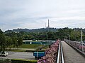
Bukit Timah Hill, is the highest natural peak in Singapore. It is located in Bukit Panjang rather than its namesake and its altitude is 164 metres (538...
4 KB (399 words) - 23:04, 11 March 2024

The Bukit Timah Nature Reserve (abbreviation: BTNR) is a 1.7-square-kilometre (0.66 sq mi) nature reserve near the geographic centre of Singapore, located...
18 KB (1,616 words) - 03:42, 28 January 2024

Nature Reserve. Bukit Panjang means "long hill" in Malay. It gets its name from the low hills which end south to Bukit Timah. The roads in the town are...
21 KB (1,798 words) - 19:39, 14 May 2024

Bukit Timah Fire Station (BTFS) (also known as the Old Bukit Timah Fire Station and the Bukit Timah Fire Station), located in Upper Bukit Timah Road,...
7 KB (590 words) - 11:43, 19 April 2024

Road (Chinese: 荷兰路) is a subzone of the Bukit Timah planning area named after the major road of the same name in Bukit Timah, Singapore. Holland Road...
3 KB (148 words) - 11:00, 24 January 2024
the hill Bukit Timah Expressway, an expressway that passes through Bukit Timah Bukit Timah Road, a road that runs through the area Bukit Timah MRT line...
1 KB (201 words) - 22:07, 27 September 2023

The Battle of Bukit Timah (10–12 February 1942), was part of the final stage of the Empire of Japan's invasion of Singapore during World War II. On 8...
6 KB (396 words) - 10:12, 5 January 2024

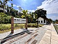
The Bukit Timah Truss Bridge is a former railway bridge going over Bukit Timah Road and Dunearn Road in Bukit Timah, Singapore. Following the diversion...
3 KB (277 words) - 10:13, 31 July 2023

Choa Chu Kang (section Road network)
Grove, Choa Chu Kang Way, Choa Chu Kang Road, Upper Bukit Timah Road, Petir Road, Jelebu Road all the way to Bukit Panjang to enhance connectivity to the...
20 KB (2,186 words) - 10:38, 20 March 2024

Hume MRT station (category Bukit Timah)
Upper Bukit Timah Road in the Hillview planning sub-zone of Bukit Batok, Singapore. It is an infill station and will be located near a number of Bukit Timah...
10 KB (726 words) - 06:29, 7 April 2024

church in Singapore. It is located at Upper Bukit Timah Road along the boundary of the Bukit Panjang and Bukit Batok planning areas, within the Northern...
9 KB (781 words) - 12:16, 8 January 2024

highest natural point after Bukit Timah Hill. Bukit Gombak is bounded by Bukit Batok Road, West Avenue 5, the North side of Bukit Gombak Sports Complex, West...
9 KB (711 words) - 14:27, 23 October 2022
in July 1947 in Singapore. It was located at the junction of Upper Bukit Timah Road and Jalan Jurong Kechil. Just next to it was Beauty World Town, another...
9 KB (1,148 words) - 14:06, 11 March 2024
Bukit Timah railway station was a former railway station and crossing loop in Bukit Timah, Singapore. Opened on the dismantled Tank Road mainline in 1903...
11 KB (977 words) - 18:48, 24 September 2023

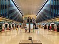
Beauty World MRT station (category Bukit Timah)
(MRT) station on the Downtown Line (DTL) in Bukit Timah, Singapore. Located along Upper Bukit Timah Road, this station took its name from the historic...
8 KB (632 words) - 14:04, 11 March 2024

King Albert Park MRT station (category Bukit Timah)
(MRT) station on the Downtown Line (DTL) in Bukit Timah, Singapore. Located at the western end of Bukit Timah Road at the junction of Blackmore Drive, this...
33 KB (2,534 words) - 01:54, 29 April 2024
Adam Road Food Centre, also known as the Adam Food Centre, is a popular hawker centre located next to the Bukit Timah Canal in Bukit Timah, Singapore...
6 KB (607 words) - 14:48, 29 May 2024
estate of Bukit Panjang, the station is at the junction of Upper Bukit Timah Road and Petir Road. The station serves the commercial buildings of Bukit Panjang...
31 KB (2,530 words) - 04:24, 1 June 2024

Pan Island Expressway (category Bukit Timah)
the rest of the PIE, a $15.2 million viaduct over Jalan Anak Bukit and Upper Bukit Timah Road was built. On 10 January 1981, the 10-kilometre (6.2 mi) segment...
26 KB (1,889 words) - 02:52, 9 April 2024
in healthcare for women and children in Singapore, located at 100 Bukit Timah Road. From its humble beginnings as a small general hospital in 1858 to...
6 KB (468 words) - 04:06, 18 April 2024
areas of Bukit Timah via Farrer Road and Adam Road, with the first connection to the Pan Island Expressway. The route continues east through Bukit Brown...
9 KB (438 words) - 10:13, 12 April 2024

Former Ford Factory (category Bukit Timah)
Ford Factory depending on sources) is located along Upper Bukit Timah Road at Bukit Timah in Singapore. It is the place where the British Army forces...
15 KB (1,371 words) - 10:22, 25 April 2024

and East, Clementi to the South, Bukit Timah to the southeast, Jurong East to the southwest and Tengah to the west. Bukit Batok largely sits on Gombak norite...
26 KB (2,003 words) - 22:51, 31 December 2023

(DTL) lines. The station is located at the junction of Bukit Timah Road and Race Course Road, on the boundary of the planning areas of Kallang and Rochor...
17 KB (1,569 words) - 09:15, 4 May 2024

and Singapore River, south of Novena, east of Bukit Timah, northeast of Queenstown and north of Bukit Merah. The name Tanglin is said to be derived from...
12 KB (892 words) - 18:36, 7 April 2024

The Rail Mall (category Bukit Timah)
strip mall located at Upper Bukit Timah Road, Singapore. The Rail Mall is located nearby the Rail Corridor and the Bukit Timah Nature Reserve. In 1994, Lee...
6 KB (474 words) - 02:44, 25 October 2023

The Bukit Timah Satellite Earth Station (Chinese: 武吉知马卫星地面站; Malay: Stesen Satelit Bumi Bukit Timah) is the second satellite earth station in Singapore...
4 KB (330 words) - 04:35, 14 December 2023