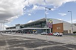
Carauari Airport (IATA: CAF, ICAO: SWCA) is the airport serving Carauari, Brazil. Note: a: Flights operated with MAP equipment on behalf of Voepass Linhas...
3 KB (155 words) - 12:36, 6 July 2024

was 28,508 (2020) and its area is 25,767 km². The city is served by Carauari Airport. The town is in the Juruá-Purus moist forests ecoregion. The municipality...
5 KB (173 words) - 16:07, 19 August 2024

International Airport. The first plane, registration PR-PDP (MSN 581), fulfilling contract no. 5900.0111285.19.2 for Petrobras and flying to Carauari and Porto...
34 KB (2,410 words) - 22:13, 20 August 2024

Santa Maria, Pelotas, Santo Ângelo and Aracati, in addition to Coari, Carauari, Parintins, Itaituba and Parnaíba, operated by MAP Linhas Aéreas on behalf...
47 KB (3,042 words) - 21:00, 16 August 2024

helipads that were open to the public in Brazil. Airport names shown in bold indicate that the airport is served by scheduled services. Note: a: Since...
52 KB (264 words) - 22:00, 1 August 2024
people. 15 December 1994: a TABA Embraer EMB 110 Bandeirante en route from Carauari and Tefé to Manaus was hijacked by two Colombian citizens. The passengers...
20 KB (1,046 words) - 13:29, 16 August 2024
List of airports by IATA airport code: A - B - C - D - E - F - G - H - I - J - K - L - M - N - O - P - Q - R - S - T - U - V - W - X - Y - Z The DST column...
89 KB (264 words) - 02:05, 7 September 2023

the press, politicians and guests in a hangar at Brasilia International Airport, Total Linhas Aéreas announced that it would resume regular passenger flights...
20 KB (1,621 words) - 04:09, 21 August 2024
30-year concession to operate the airport. 15 December 1994: a TABA Embraer EMB 110 Bandeirante en route from Carauari and Tefé to Manaus was hijacked by...
5 KB (243 words) - 10:34, 9 June 2024
December 4, 2007, with its headquarters at Plácido de Castro International Airport in Rio Branco, Acre. The company's name is a tribute to the Acre River...
14 KB (1,047 words) - 08:38, 8 August 2024
Amazonas SWCA (CAF) – Carauari Airport – Carauari, Amazonas SWEI (ERN) – Eirunepé Airport – Eirunepé, Amazonas SWEK (CQA) – Canarana Airport – Canarana, Mato...
87 KB (7,871 words) - 23:32, 17 August 2024
Urucu Airport (IATA: RPU, ICAO: SBUY) is the airport serving the district of Porto Urucu in Coari, Brazil. It is operated by Petrobras. The airport was...
3 KB (135 words) - 12:37, 6 July 2024

Boca do Acre, Cruzeiro do Sul, Rio Branco, Tarauacá Amazonas Barcelos, Carauari, Eirunepé, Fonte Boa, Humaitá, Ipiranga, Lábrea, Novo Aripuanã, Parintins...
9 KB (766 words) - 17:19, 11 August 2024

for Brazil's major cities. The city is served by Tabatinga International Airport, and Tabatinga port where passengers can travel downriver by boat to Manaus...
12 KB (1,173 words) - 16:06, 19 August 2024

for Carauari. Revises the boundaries of the municipalities of the State, by Decree No. 122, August 7, 1896, the seat of the Municipality of Carauari been...
16 KB (1,225 words) - 16:09, 19 August 2024

oil and natural gas. Coari is served by Coari Airport located 6 km from downtown Coari. Porto Urucu Airport located in the district of Porto Urucu 470 km...
8 KB (241 words) - 03:02, 19 August 2024

located on the banks of the Madeira River. The city is served by Humaitá Airport. The Trans-Amazonian Highway passes through the city. The municipality...
5 KB (193 words) - 20:30, 19 August 2024

005 (2020) and its area is 12,111 km². The city is served by Fonte Boa Airport. The municipality contains 45% of the 146,950 hectares (363,100 acres)...
6 KB (120 words) - 16:03, 19 August 2024

an area of 19,746 km². The city is served by Senadora Eunice Michiles Airport. This city, along with other surrounding cities, is known for their sand...
4 KB (152 words) - 16:05, 19 August 2024

Manaus. Azul Linhas Aereas and Voepass operate flights from Manaus to Tefé Airport. The city is the home of the Territorial Prelature of Tefé. Tefé is also...
11 KB (673 words) - 03:13, 19 August 2024

south-east of the Brazilian state of Amazonas. The city is served by Manicoré Airport. Santo Antônio de Matupi is a major centre of logging in the region. Manicoré's...
10 KB (656 words) - 20:30, 19 August 2024

of Amazonas. Its population was 32,483 (2020) and its area is 5,751 km². The locality is served by the Barreirinha Airport. IBGE 2020 IBGE - [1] v t e...
3 KB (37 words) - 03:08, 19 August 2024

Amazonas (Brazilian state) (section Airports)
International Airport is Brazil's third largest in freight movement, handling the import and export demand from the Manaus Industrial Complex. Other airports include...
62 KB (6,476 words) - 13:50, 20 June 2024

3 mm, followed by 709.2 mm in January 2013. It is served by Júlio Belém Airport. Wikimedia Commons has media related to Parintins (Amazonas). IBGE 2020...
14 KB (971 words) - 03:09, 19 August 2024

part of the Amazonas National Forest. The city is served by Tapuruquara Airport. IBGE 2020 IBGE - [1] Unidade de Conservação: Floresta Nacional do Amazonas...
3 KB (161 words) - 16:01, 19 August 2024

correspondingly hot and humid. The city is served by São Gabriel da Cachoeira Airport. The municipality contains the 36,900 hectares (91,000 acres) Morro dos...
11 KB (462 words) - 16:01, 19 August 2024

created in 1955 out of São Paulo de Olivença. The city is served by Ipiranga Airport. The municipality contains the 15,000 hectares (37,000 acres) Javari-Buriti...
4 KB (131 words) - 16:04, 19 August 2024
persons. 15 December 1994: an Embraer EMB 110 Bandeirante en route from Carauari and Tefé to Manaus was hijacked by two Colombian citizens. The passengers...
13 KB (1,194 words) - 16:25, 17 February 2024

is about 31 hours from Manaus (about 7 days by slow boat). The nearest airport is at Tabatinga, 2 hours by boat. IBGE 2020 IBGE website Archived January...
7 KB (229 words) - 16:03, 19 August 2024