
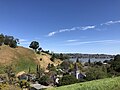
Carquinez Strait Regional Shoreline is a regional park, part of the East Bay Regional Park District system, located in northwestern Contra Costa County...
5 KB (532 words) - 17:18, 29 April 2024

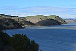
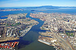
The Carquinez Strait (/kɑːrˈkiːnəs/; Spanish: Estrecho de Carquinez) is a narrow tidal strait located in the Bay Area of Northern California, United States...
12 KB (1,281 words) - 17:17, 29 April 2024
Martinez, California (category Carquinez Strait)
area. The Martinez Regional Shoreline bounds the city to the north along the Carquinez Strait. Carquinez Strait Regional Shoreline includes the Franklin...
36 KB (3,201 words) - 07:58, 11 August 2024
Port Costa, California (category Carquinez Strait)
hills grazed by cattle and managed by East Bay Regional Park District. Carquinez Strait Regional Shoreline stretches from Crockett through Port Costa and...
14 KB (1,339 words) - 10:47, 31 July 2024

Radke Martinez Regional Shoreline (RMRS) is a regional park on the shoreline of Carquinez Strait in Martinez, located in northern Contra Costa County...
4 KB (354 words) - 20:44, 30 May 2024
Island Regional Preserve Browns Island Regional Shoreline Brushy Peak Regional Preserve Carquinez Strait Regional Shoreline Castle Rock Regional Recreational...
29 KB (3,167 words) - 20:31, 13 July 2024

pedestrian lanes exist on six Bay Area toll bridges: Golden Gate Bridge, Carquinez Bridge, Benicia-Martinez Bridge, Dumbarton Bridge, the Richmond-San Rafael...
7 KB (761 words) - 17:51, 4 January 2024
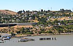
Crockett, California (category Carquinez Strait)
excellent mountain biking park. Carquinez Strait Regional Shoreline comprises 1,415 acres of bluffs and shoreline along Carquinez Scenic Drive between the town...
24 KB (2,178 words) - 23:40, 7 August 2024

designated and non-designated trails, including a crossing of the Carquinez Strait by kayak. The first two segments of the trail, dedicated on May 13...
13 KB (1,108 words) - 21:37, 26 May 2024

California. Eckley is gone, the site now being part of Carquinez Strait Regional Shoreline Park, and the remains of the Garden City are easily visible...
33 KB (2,825 words) - 05:10, 24 July 2024

Nevada mountains, flow into Suisun Bay, which then travels through the Carquinez Strait to meet with the Napa River at the entrance to San Pablo Bay, which...
57 KB (5,827 words) - 08:21, 15 August 2024

early 1990s the East Bay Regional Park District dedicated the Nejedly Staging Area at the new Carquinez Strait Regional Shoreline in the retired State Senator's...
15 KB (1,630 words) - 10:31, 3 August 2024

Regional Park Carquinez Strait Regional Shoreline Fernandez Ranch Bolinas Ridge Pinole Valley Watershed Muir Beach Overlook Sobrante Ridge Regional Park...
7 KB (541 words) - 17:12, 3 June 2024

and was settled into the mud flats of Martinez, California, in the Carquinez Strait, where it sat to rot until burning down in 1975. All that remains today...
3 KB (198 words) - 19:42, 7 September 2023

the Central Valley. The overflow rapidly carved an outlet through Carquinez Strait, probably catastrophically, and drained the lake. The Upper Turbidite...
10 KB (977 words) - 14:34, 16 May 2024

sediments behind the Carquinez Strait, the sole outlet from the Central Valley to San Pablo Bay. The narrowness of the Carquinez Strait coupled with tidal...
66 KB (7,404 words) - 10:49, 15 August 2024

of the country until about 1879 when a more direct route across the Carquinez Strait was completed. Today, Altamont Corridor Express (ACE) operates commuter...
27 KB (2,429 words) - 01:48, 8 August 2024
Francisco. The Napa River forms its eastern side as it enters the Carquinez Strait juncture with the east side of San Pablo Bay. Mare Island is a peninsula...
22 KB (2,424 words) - 18:42, 17 June 2024
Castle Rock Regional Recreation Area is a 18,000 acres (73 km2) regional park of the East Bay Regional Park District. It is located in Contra Costa County...
2 KB (143 words) - 09:42, 25 March 2022
grasslands, wooded ravines and shoreline along the south bank of the Carquinez Strait. Its elevation ranges from 100 feet (30 m) to 800 feet (240 m) above...
4 KB (410 words) - 19:30, 26 September 2022

military officer and later a U.S. Representative from California. The Carquinez Strait is part of the John F. Baldwin Shipping Channel. Also on the John F...
9 KB (928 words) - 17:54, 6 June 2022

close to several regional nature preserves including Point Pinole Regional Shoreline, Crockett Hills Regional Park, Carquinez Strait, Wildcat Canyon and...
42 KB (4,353 words) - 18:03, 18 June 2024
Citizens for East Shore Parks (category East Bay Regional Park District)
San Francisco Bay, creating a necklace of shoreline parks from the Oakland Estuary to the Carquinez Strait. CESP has a twenty-five member volunteer Board...
16 KB (2,038 words) - 13:38, 23 September 2022
7947278°N 122.3152556°W / 37.7947278; -122.3152556 The Oakland Estuary is the strait in the San Francisco Bay Area, California, separating the cities of Oakland...
5 KB (474 words) - 05:08, 17 September 2023

Reservoir Straits and estuaries Clifton Court Forebay Carquinez Strait Oakland Estuary Raccoon Strait Sacramento–San Joaquin River Delta Stockton Deepwater...
3 KB (210 words) - 21:27, 10 April 2023

Base—Hamilton Army Airfield (1930−1988) site and adjacent Bel Marin Keys shoreline, in Marin County, California. It is located at Whiteside Marsh on the...
3 KB (270 words) - 06:09, 29 May 2024

Alhambra Creek (category Carquinez Strait)
Francisco Bay Area in northern California. The creek drains into the Carquinez Strait at Martinez, via the historical Arroyo del Hambre. Alhambra Creek and...
25 KB (3,024 words) - 01:54, 21 April 2024

Diablo Foothills Regional Park is a 1,060 acres (4.3 km2) regional park of the East Bay Regional Park District. It is located in Contra Costa County,...
2 KB (144 words) - 14:25, 11 June 2024

the Sacramento and San Joaquin Rivers. The water is drained by the Carquinez Strait, which flows into San Pablo Bay, a northern extension of San Francisco...
280 KB (24,118 words) - 03:20, 14 August 2024

of San Bruno Mountain to fill 27 miles (44km) of the San Mateo County shoreline. This work has been noted as the first successful conservation effort...
6 KB (463 words) - 16:26, 25 June 2024