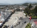
Chimaltenango is a city in Guatemala with a population of 96,985 (2018 census). It serves as both the capital of the department of Chimaltenango and the...
14 KB (822 words) - 17:13, 5 April 2024

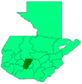
Chimaltenango is a department of Guatemala. The capital is Chimaltenango. Located to the east are Guatemala Department, home to Guatemala City, and Sacatepéquez...
7 KB (224 words) - 21:04, 7 October 2023

southwestern region of Guatemala, bordering Quetzaltenango, Sololá, and Chimaltenango to the north, the Pacific Ocean to the south, Escuintla to the east...
6 KB (137 words) - 01:14, 13 August 2024

The Roman Catholic Diocese of Sololá-Chimaltenango is a Latin suffragan diocese in the ecclesiastical province of the Archdiocese of Los Altos...
6 KB (334 words) - 19:31, 30 January 2023

San Juan Comalapa (redirect from Comalapa, Chimaltenango)
with a population of 32,312 (2018 census), and a municipality in the Chimaltenango department of Guatemala. San Juan Comalapa is sometimes called the "Florence...
12 KB (844 words) - 15:46, 24 April 2024
Club América de Chimaltenango, is a Guatemalan football club based in Chimaltenango, Chimaltenango Department. They play their home games in the Estadio...
4 KB (151 words) - 02:55, 12 May 2021

El Tejar is a municipality and town in the Chimaltenango department of Guatemala. As of 2018, the municipality has a population of 15,639. El Tejar was...
6 KB (146 words) - 19:02, 8 July 2024
Oedipina ignea (redirect from Chimaltenango worm salamander)
Oedipina ignea is a species of salamander in the family Plethodontidae. It is found in Guatemala, Honduras, and possibly El Salvador. Its natural habitat...
889 bytes (71 words) - 06:48, 25 November 2021
Santa Apolonia is a municipality in the northern part of Chimaltenango department of Guatemala. Santa Apolonia is bordered by the towns of Tecpán to the...
5 KB (368 words) - 15:24, 15 September 2023
approximately 50 children. Two other schools have since been organized, one in Chimaltenango and the other in Momostenango. In addition to these schools, the Rose...
3 KB (279 words) - 21:37, 8 September 2024
Acatenango is a town and municipality in the Chimaltenango department of Guatemala. It is in this municipality that the Acatenango volcano is located...
16 KB (1,042 words) - 15:28, 12 December 2023

91°43′34″W / 15.48139°N 91.72611°W / 15.48139; -91.72611 Santiago Chimaltenango is a town and municipality in the Guatemalan department of Huehuetenango...
9 KB (367 words) - 15:23, 15 September 2023
with a population of 11,176 (2018 census), and a municipality in the Chimaltenango department of Guatemala. One of the earliest references to the town...
12 KB (643 words) - 04:10, 15 August 2024

1,215,038 17 Baja Verapaz 2 GT-15 Salamá 3,124 299,476 8 Chimaltenango 3 GT-04 Chimaltenango 1,979 615,776 16 Chiquimula 4 GT-20 Chiquimula 2,376 415...
15 KB (252 words) - 08:11, 1 September 2024

colonial capital of Guatemala Chimaltenango 28 August 1524 Kaqchikel abandon Iximche and break alliance Chimaltenango 7 September 1524 Spanish declare...
9 KB (396 words) - 00:22, 24 September 2024
Guatemala were the two municipalities belonging to the department of Chimaltenango. On September 12, 1839, the department of Sacatepéquez was created,...
1,015 bytes (78 words) - 06:06, 15 August 2024

headquarters for the Catholic Bishopric encompassing the Sololá and Chimaltenango Departments. Almost all residents of Sololá are Kaqchikel Maya, except...
8 KB (323 words) - 15:10, 15 September 2023

Kaqchikel people (category Chimaltenango Department)
and Champotón. In Guatemala they live in the departments of Sololá, Chimaltenango and Sacatepéquez. In Postclassic Maya times the capital of the main...
5 KB (383 words) - 10:20, 2 May 2024
Verapaz Chiquimula El Progreso Izabal Zacapa Jutiapa Jalapa Santa Rosa Chimaltenango Sacatepéquez Escuintla Quetzaltenango Retalhuleu San Marcos Suchitepéquez...
2 KB (56 words) - 12:25, 8 February 2024
colonial capital of Guatemala Chimaltenango 28 August 1524 Kaqchikel abandon Iximche and break alliance Chimaltenango 7 September 1524 Spanish declare...
58 KB (5,708 words) - 22:32, 22 September 2024

fire is") is an active stratovolcano in Guatemala, on the borders of Chimaltenango, Escuintla and Sacatepéquez departments. Part of the mountain range...
26 KB (2,261 words) - 08:17, 15 September 2024
archaeological sites (Tikal in the Petén, Quiriguá in Izabal, Iximche in Tecpan Chimaltenango, and in the City of Guatemala). Destinations visited for their natural...
6 KB (411 words) - 05:43, 4 June 2024

Tecpán, Guatemala (category Municipalities of the Chimaltenango Department)
population of 34,519 (2018 census), and a municipality in the department of Chimaltenango, in Guatemala, on the Inter-American Highway CA-1. The climate is generally...
7 KB (262 words) - 16:09, 18 August 2024

Huehuetenango to Chimaltenango is roughly 160 km (99 mi) with Mayan ruins at Iximché, just north of Tecpán Guatemala. From Chimaltenango, it is about 35...
71 KB (8,734 words) - 10:49, 26 September 2024

the death squads in the city were disposed of in San Juan Comalapa, Chimaltenango Department, which became notorious as a dumping ground for cadavers...
116 KB (13,132 words) - 06:07, 18 September 2024

Municipalities of Guatemala (section Chimaltenango)
N. Municipalities Area (km2) Population (2018) Density 1 Chimaltenango 86 116 642 1356.3 2 San José Poaquíl 100 33 932 339.32 3 San Martín Jilotepeque...
24 KB (60 words) - 08:38, 18 September 2024

north of the municipality of Escuintla is Yepocapa (municipality of Chimaltenango) and Alotenango (municipality of Sacatepequez). To the East is Palin...
13 KB (653 words) - 00:11, 13 August 2024
7179°N 107.1994°W / 38.7179; -107.1994 134 Volcán Acatenango Guatemala Chimaltenango 3975 m 13,041 ft 1835 m 6,020 ft 125.9 km 78.2 mi 14°30′06″N 90°52′32″W...
114 KB (9,521 words) - 04:02, 5 August 2024

volcanic mountain range on the department's South-Western border with Chimaltenango, which together make up for 79% of the department's territory. The northern...
13 KB (795 words) - 08:08, 18 September 2024