Cleveland–Redland Bay Road is a continuous 15.2 kilometres (9.4 mi) road route in the Redland local government area of Queensland, Australia. The route...
15 KB (1,236 words) - 16:48, 25 July 2024
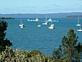
coordinates) Redland Bay is a coastal semi-rural locality in the City of Redland, Queensland, Australia. In the 2021 census, Redland Bay had a population...
28 KB (2,895 words) - 17:59, 25 July 2024

(secondary coordinates) Cleveland is a coastal and central locality in the City of Redland, Queensland, Australia. In the 2021 census, Cleveland had a population...
35 KB (3,234 words) - 16:48, 25 July 2024

clear city centre. Major suburbs include Capalaba, Cleveland, Victoria Point, Thornlands, and Redland Bay. The latter is the city's namesake, due to the colour...
54 KB (4,260 words) - 05:04, 21 August 2024
Beenleigh–Redland Bay Road is a continuous 16.5 kilometres (10.3 mi) road route in the Logan and Redland local government areas of Queensland, Australia...
8 KB (625 words) - 16:35, 25 July 2024

(AA21 – YB24). Cleveland to Redland Bay and Mt. Cotton. RB 21 SHEET 2. 1889. Series 4611, Item 805633. Queensland State Archives. "REDLAND RAILWAY". The...
10 KB (884 words) - 02:07, 16 July 2024

Victoria Point, Queensland (category Suburbs of Redland City)
centre, a liberty and a ferry service to Coochiemudlo Island. The Cleveland-Redland Bay Road traverses Victoria Point from north to south, passing in between...
16 KB (1,562 words) - 18:24, 25 July 2024

Redland Bay State School Residence is a heritage-listed house at Gordon Road, Redland Bay, City of Redland, Queensland, Australia. It was designed by Robert...
10 KB (1,277 words) - 17:31, 9 January 2024
Thornlands, Queensland (redirect from Thornlands, Redland City)
(20 mi) by road south-east Brisbane, the capital of the Queensland. Major access to Thornlands is provided by Boundary Road, Cleveland-Redland Bay Road, or Wellington...
17 KB (1,617 words) - 18:17, 25 July 2024

Cleveland railway station is located on the Cleveland line in Queensland, Australia. It serves the suburb of Cleveland in the Redland City. In 1889, the...
9 KB (473 words) - 09:10, 1 September 2024

Brisbane City Council proposal to rename the current Old Cleveland Road was halted after the Redland City council objected to the change. Between 1912 and...
12 KB (787 words) - 09:42, 23 January 2024
state-controlled roads intersect with section 10A: Redcliffe Road (Anzac Avenue) Deception Bay Road Burpengary Service Road Burpengary–Caboolture Road Caboolture...
40 KB (3,348 words) - 15:45, 4 April 2024

Ormiston in the City of Redland. The bay was named by the surveyor James Warner on 1 July 1841, after the Duke of Cleveland who was also known as Baron...
5 KB (594 words) - 02:25, 12 August 2024

Capalaba, Queensland (category Suburbs of Redland City)
Ney Road. The first drive-in movie theatre in Queensland opened at Capalaba in December 1955 at the corner of Redland Bay Road and Mount Cotton Road (27°31′20″S...
38 KB (3,687 words) - 13:13, 24 April 2024

Serpentine Creek Road Cemetery is a heritage-listed cemetery at 398-408 Serpentine Creek Road, Redland Bay, Redland City, Queensland, Australia. It was...
15 KB (2,055 words) - 04:27, 8 April 2023

Bruce Highway (category WikiProject Australian Roads articles with a junction list using templates)
from the Wide Bay Highway interchange to the Maryborough–Biggenden Road interchange at Maryborough passes through Tiaro and the Gympie Road exit to Maryborough...
103 KB (5,393 words) - 07:55, 6 August 2024

population of 3,698 people. Russell Island in Redland City is the biggest of the Southern Moreton Bay Islands, situated between the mainland and North...
29 KB (2,856 words) - 14:57, 29 August 2024

Burnett Highway (redirect from Murgon–Barambah Road)
State Road Network of Queensland (PDF) (Map). Queensland Government ©State of Queensland [CC BY 4.0]. 30 June 2022. Retrieved 4 August 2023. "Wide Bay / Burnett...
15 KB (926 words) - 06:03, 27 April 2024
Tin Can Bay Road is a continuous 56.1 kilometres (34.9 mi) road route in the Gympie region of Queensland, Australia. Part of it is signed as State Route...
14 KB (1,173 words) - 03:15, 17 August 2024

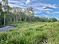
Mount Cotton, Queensland (category Suburbs of Redland City)
An extension of the Cleveland railway line to Redland Bay and Mount Cotton was surveyed in 1889. The extension to Redland Bay was recommended by the...
18 KB (1,723 words) - 04:34, 28 May 2024

Coochiemudlo Island (category Suburbs of Redland City)
which is within the local government area of Redland City, but town is called Coochie. There is no road access to the island, which is a 2.0-kilometre...
18 KB (1,690 words) - 01:25, 2 June 2024
Haigslea–Amberley Road Rosewood–Marburg Road Laidley–Plainland Road Forest Hill–Fernvale Road Gatton–Esk Road Gatton–Helidon Road Toowoomba Second Range...
23 KB (1,932 words) - 00:40, 22 January 2024
state-controlled roads intersect with section 25A: Camp Cable Road Beaudesert–Boonah Road Camp Cable Road is a state-controlled district road (number 2071)...
6 KB (516 words) - 02:20, 5 March 2024
Crossing Road Kalbar Connection Road Boonah–Fassifern Road Lake Moogerah Road New England Highway Freestone Road Warwick–Yangan Road Warwick–Allora Road Warwick–Killarney...
22 KB (1,802 words) - 22:38, 9 February 2024

Mulligan Highway (redirect from Cooktown Developmental Road)
Developmental Road, the following state-controlled roads are linked to this road: Mareeba–Dimbulah Road Mossman–Mount Molloy Road Mareeba–Dimbulah Road is a state-controlled...
5 KB (280 words) - 17:42, 25 July 2024
2022. Retrieved 4 August 2023. "Wide Bay / Burnett district map - Page 1" (PDF). Department of Transport and Main Roads ©State of Queensland [CC BY 4.0]....
12 KB (828 words) - 16:41, 25 July 2024
Roma–Condamine Road is a continuous 115-kilometre (71 mi) road route in the Maranoa and Western Downs local government areas of Queensland, Australia...
12 KB (1,042 words) - 03:48, 17 August 2024
Road routes in Queensland assist drivers navigating roads throughout the state, by identifying important through-routes. Queensland is in the process...
81 KB (670 words) - 20:26, 24 January 2024

Outback Highway (category WikiProject Australian Roads articles with a junction list using templates)
The Outback Highway or Outback Way is a series of roads and dirt tracks linking Laverton, Western Australia and Winton, Queensland. At 2,719 km (1,690 mi)...
9 KB (314 words) - 05:03, 11 February 2024
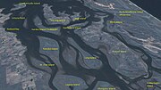
Southern Moreton Bay Islands are mostly surrounded by the Southern Moreton Bay Islands National Park, which is also located within Redland City. The population...
14 KB (1,116 words) - 16:28, 16 June 2024