
Coolah is a town in the central western part of New South Wales, Australia in Warrumbungle Shire. At the 2016 census, Coolah had a population of 1,290...
7 KB (592 words) - 09:51, 24 February 2024

Coolah Parish is a civil parish of the County of Napier, a county in the central western part of New South Wales, Australia in Warrumbungle Shire. The...
4 KB (244 words) - 21:00, 21 November 2020
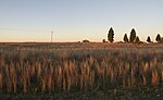
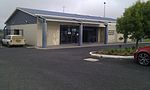
Coolah Airport (IATA: CLH, ICAO: YCAH) is located 6.5 nautical miles (12.0 km; 7.5 mi) northwest of Coolah, New South Wales, Australia. List of airports...
1 KB (54 words) - 23:45, 31 January 2024

Black Stump (section Coolah, New South Wales)
Hanson, The Pastoral Possessions of New South Wales, Gibbs, Shallard & Co, 1889, p. 334 The Black Stump (Coolah) Archived 20 August 2006 at the Wayback...
18 KB (2,268 words) - 15:54, 16 August 2024
Binnia Street, Coolah, in the Warrumbungle Shire, New South Wales, Australia. It was designed by the Colonial Architect of New South Wales, James Barnet...
5 KB (580 words) - 05:48, 8 September 2023

Coolah Tops is a national park located in New South Wales, Australia, 258 kilometres (160 mi) northwest of Sydney, established on 5 July 1996. It is managed...
3 KB (216 words) - 22:49, 5 March 2024
Orana is a vast region in central-northern New South Wales, Australia. As of June 2015[update] it had an estimated population of 113,824 people. It has...
6 KB (478 words) - 03:44, 30 June 2024

western New South Wales. The civil parish is located outside of Coolah, New South Wales, and by some accounts is the location of the proverbial Black Stump...
2 KB (180 words) - 21:00, 18 October 2022

Tambar Springs is a town in the North West Slopes region of New South Wales, Australia. At the 2016 census, Tambar Springs and the surrounding area had...
5 KB (280 words) - 01:24, 23 May 2024

Wine Saloon that once stood about 10 kilometres (6.2 mi) out of Coolah, New South Wales on the Gunnedah Road. It is claimed that the saloon, named after...
31 KB (3,010 words) - 07:27, 12 August 2024

outskirts of Sydney, 1 nautical mile (1.9 km; 1.2 mi) northwest of Camden, New South Wales, Australia. The airport is located approximately 60 km (37 mi) from...
13 KB (1,235 words) - 12:15, 18 February 2024

September 2020. Parliament of New South Wales (21 December 1915). "CRABOON TO COOLAH RAILWAY ACT. - Act No. 50 1915". "Coolah Branch". www.nswrail.net. Retrieved...
25 KB (2,816 words) - 23:10, 4 May 2024
of Parramatta (1997–2010). Manning was born 1933 in Coolah, Warrumbungle Shire, New South Wales. In the era of depression years and the disruption of...
8 KB (741 words) - 05:37, 28 July 2024
Environment of New South Wales. Abercrombie River National Park Breelong National Park Capertee National Park Conimbla National Park Coolah Tops National...
37 KB (3,664 words) - 08:39, 20 July 2024
Napier County (redirect from Napier County, New South Wales)
coordinates) Napier County is one of the 141 cadastral divisions of New South Wales. Napier County is named in honour of Field Marshal Robert Cornelius...
6 KB (93 words) - 06:57, 6 August 2024
The New South Wales Department of Education is a department of the Government of New South Wales. In addition to other responsibilities, it operates primary...
24 KB (51 words) - 14:30, 1 July 2024
New South Wales. It is correct as of June 2023. New South Wales portal Schools portal Catholicism portal List of non-government schools in New South Wales...
150 KB (63 words) - 03:24, 13 April 2024

is a small town located on the Castlereagh River in central western New South Wales near the larger centre of Coonabarabran, which is about 35 kilometres...
7 KB (960 words) - 18:10, 19 May 2024

western part of New South Wales, Australia, in Warrumbungle Shire. On the northeastern side of the area is the Liverpool Range with the Coolah Tops National...
2 KB (172 words) - 21:02, 21 November 2020
Bathurst Airport (IATA: BHS, ICAO: YBTH) is an airport serving Bathurst, New South Wales, Australia. Located in the Central Tablelands, Bathurst Airport is...
22 KB (2,059 words) - 13:48, 3 March 2024
inspector, and a former Governor of Tasmania. Butler was born in Coolah in rural New South Wales. He grew up in Sydney and was educated at Randwick Boys High...
20 KB (2,375 words) - 05:45, 24 December 2023

Dunedoo (redirect from Dunedoo, New South Wales)
inhabitants situated within the Warrumbungle Shire of central western New South Wales, Australia. Dunedoo is well known to Australian travellers due to its...
15 KB (1,352 words) - 17:40, 16 February 2024
kilometres WSW of the nearest significant town, Quirindi. To the south of Blackville is the Coolah Tops National Park. Blackville Public School is a primary...
1 KB (93 words) - 22:14, 22 June 2024

New South Wales experienced the first gold rush in Australia, a period generally accepted to lie between 1851 and 1880. This period in the history of...
27 KB (2,539 words) - 01:15, 2 June 2024
Coolah Shire was a local government area in New South Wales, Australia from 1906 to 1994. It was established under the Local Government (Shires) Act 1905...
2 KB (215 words) - 14:08, 13 July 2023
North West Slopes (redirect from North West Slopes, New South Wales)
The North West Slopes region of New South Wales, Australia, refers generally to the area west of the Northern Tablelands, to the north of the Central...
7 KB (648 words) - 20:56, 2 March 2024
Mitchell Shire was a local government area in the Riverina region of New South Wales, Australia. Mitchell Shire was proclaimed on 7 March 1906, one of 134...
2 KB (158 words) - 11:42, 13 July 2023

Airport (IATA: NTL, ICAO: YWLM) is a domestic airport in Williamtown, New South Wales. It is located 15 kilometres; 9.2 miles (8 NM) north of Newcastle (27 km...
27 KB (2,124 words) - 22:51, 11 August 2024
This is a list of New South Wales Rugby League clubs by competition. There are over 450 clubs in New South Wales, across over 30 competitions administered...
60 KB (892 words) - 11:54, 24 June 2024
Forest Hill Gobbabaula Grong Grong Road Junee Road Kendalls Lake Albert Lake Coolah Narrandera, see RAAF Station Narrandera Pucawan Temora Tootool Uranquinty...
29 KB (2,433 words) - 22:28, 29 May 2024