Wallanka mountain range - one part of the Cordillera Occidental in the Andes mountain range in western Peru Río Huallanca - headwaters of Marañón River (Peru)...
703 bytes (131 words) - 18:03, 19 December 2016
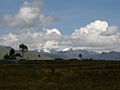
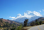
Ancash Region, Bolognesi Province. The Huallanca mountain range is a small range southeast of the Cordillera Blanca and north of the Huayhuash mountain...
4 KB (388 words) - 11:26, 30 October 2021
in rivers and lagoons of the Cordillera Blanca and Cordillera Negra at any time of the year. From Chimbote to Huallanca, there are approximately 140 km...
40 KB (3,840 words) - 23:56, 12 August 2024
mincetur. Retrieved April 9, 2015. Hugh R. Clark, South America, Peru–Cordilleras Huallanca, Huayhuash and Raura, Nevado Shicra Shicra, and Other Peaks, American...
3 KB (218 words) - 05:29, 15 April 2022
tunnels before it emerges onto the western face of the Cordillera Negra high above the town of Huallanca. The river from this same bridge goes generally northward...
4 KB (617 words) - 22:20, 26 August 2021

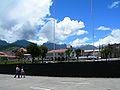
It is in the high mountain range known as Cordillera Negra ("Black Range"). The district capital is Huallanca. The district was founded in 1950 by separating...
4 KB (297 words) - 17:11, 12 January 2020
Huayhuash Cordillera Negra Cordillera Occidental (Peru) Cordillera Oriental (Peru) Cordillera Vilcanota Huaguruncho mountain range Huallanca mountain range...
8 KB (486 words) - 15:34, 7 July 2024

the Huallanca mountain range in the Andes of Peru. It is located in the Ancash Region, Bolognesi Province, in the districts of Aquia and Huallanca. Alfred...
2 KB (116 words) - 05:24, 15 April 2022

fluctuation of the river. Upstream of the hydroelectric power plant at Huallanca, the Santa River watershed covers an area of 4,900 km2, downstream another...
5 KB (550 words) - 08:20, 14 April 2024
qucha lake, "lake of the bifurcation") is a mountain in the north of the Huallanca mountain range in the Andes of Peru at a small lake of that name. The...
2 KB (192 words) - 07:35, 3 August 2020

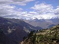
stretch, the rocks of the Cordillera Blanca and Cordillera Negra come closer (less than 5 m of distance). To arrive to Huallanca, at the north end of the...
5 KB (411 words) - 17:11, 12 January 2020
the Ancash Region, Bolognesi Province, in the districts of Aquia and Huallanca. "Nevado Tancan". IGN, Peru. Retrieved March 2, 2015. "Diccionario: Quechua...
2 KB (158 words) - 01:55, 16 April 2022
Wari Hirka Wathiya Wathiya Wayi Sinqa Wayllas Yana Hirka Yana Hirka (Huallanca) Yana Jaqhi Yana Puyku Yana Wank'a Yanarahu Yanashallash Yuraq Punta Yuraq...
5 KB (361 words) - 21:50, 18 April 2022
lake,) is a lake in the Huallanca District of Bolognesi Province, in Peru's Ancash Region. It is northeast of the Cordillera Huayhuash, south of Lake...
1 KB (79 words) - 12:24, 24 May 2024

the narrow Cañón del Pato (Duck Canyon), turns westward at the town of Huallanca, and continues to the coast where it enters the Pacific Ocean south of...
42 KB (5,277 words) - 01:19, 27 August 2024

Region, Bolognesi Province, on the border of the districts of Aquia and Huallanca. Kuntur Wayi lies east of the Minapata valley, southwest of Kunkush, south...
3 KB (149 words) - 05:37, 15 April 2022

1970 Huascarán debris avalanche (category Deaths in the Cordillera Blanca)
also destroyed, although the power station itself was unharmed.: 12 At Huallanca below Cañon del Pato, the river reportedly dried up for an hour after...
33 KB (4,135 words) - 20:04, 28 August 2024
Elevation Name Range Coordinates Image Country 6,961 Aconcagua Principal Cordillera 32°39′S 70°01′W / 32.650°S 70.017°W / -32.650; -70.017 (Aconcagua)...
61 KB (174 words) - 21:34, 18 April 2024

and an area of 184,165 km². Its topography seems jagged because of the Cordillera Blanca of Tucuchira, which is characterized for its everlasting snow mountains...
5 KB (224 words) - 02:31, 7 June 2024

District is one of twelve districts of the province Huaraz in Peru. The Cordillera Blanca traverses the district. Some of the highest peaks of the district...
4 KB (174 words) - 17:36, 12 January 2020

census. The District of Aija is located on the western slopes of the Cordillera Negra. It borders on Recuay Province to the south and east, on Coris District...
4 KB (154 words) - 04:15, 13 January 2023

is one of 20 provinces of the Ancash Region in Peru. The Cordillera Blanca and the Cordillera Negra traverse the province. Some of the highest peaks of...
5 KB (253 words) - 21:53, 18 April 2022
means 'country of water' in Kulyi language (kon water, chucu country). Cordillera Blanca (in Spanish) Instituto Nacional de Estadística e Informática. Banco...
4 KB (165 words) - 22:54, 1 December 2021

the south-western part of the province at an elevation of 2,862m in the Cordillera Negra (Spanish for black mountain range). The capital of the province...
6 KB (297 words) - 17:11, 12 January 2020

the Ancash region, Peru. It was created by law on October 28, 1904. The Cordillera Blanca traverses the province. Waskaran, the highest elevation of Peru...
6 KB (458 words) - 00:54, 16 May 2024
of twelve districts of the province Huaraz in Peru. The Cordillera Blanca and the Cordillera Negra traverse the district. Some of the highest mountains...
3 KB (105 words) - 17:35, 12 January 2020

regions capital Huaraz and 55 km from the province's capital Caraz. The Cordillera Blanca traverses the province. Some of the highest mountains of the district...
5 KB (287 words) - 17:11, 12 January 2020

the province at an elevation of 2,239m in the black mountains (Spanish: Cordillera Negra), neighboring district is the Caraz district in which the provinces...
4 KB (222 words) - 17:11, 12 January 2020

the province at an elevation of 2,736m in the black mountains (Spanish: Cordillera Negra), neighboring district is the Caraz district in which the provinces...
5 KB (271 words) - 17:11, 12 January 2020

central-eastern part of the province at an elevation of 2,900 m. The Cordillera Blanca traverses the district. Some of the highest mountains of the district...
5 KB (252 words) - 03:18, 10 January 2021