
The Eastmain River, formerly written East Main, is a river in west central Quebec. It rises in central Quebec and flows 800 km (500 mi) west to James Bay...
7 KB (420 words) - 13:47, 12 September 2023

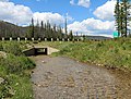
Cree community located on east coast of James Bay at the mouth of the Eastmain River, Quebec, Canada. It is a small coastal Cree village with a population...
13 KB (604 words) - 20:52, 8 July 2024
Eastmain River Airport (IATA: ZEM, ICAO: CZEM), is located 1 nautical mile (1.9 km; 1.2 mi) southwest of Eastmain, Quebec, Canada. Canada Flight Supplement...
2 KB (90 words) - 17:38, 30 January 2024

Since the 1980s, when hydroelectric development diverted the Eastmain and Caniapiscau rivers into the La Grande, its total catchment area has increased...
8 KB (683 words) - 12:56, 17 April 2024

"Rivière Eastmain". The Atlas of Canada. Natural Resources Canada. Archived from the original on July 7, 2012. Retrieved May 26, 2011. "Attawapiskat River, Ontario"...
63 KB (2,899 words) - 22:40, 3 June 2024

to the Eastmain 1 Reservoir. The remaining work was complete in 2012. Rupert River at the Route du Nord The Rupert River lookout The Rupert River at the...
10 KB (824 words) - 08:37, 18 May 2024

James Bay Project (section Great Whale River project)
between 2003 and 2011 — the Eastmain-1, Eastmain-1-A and Sarcelle generating stations — and the diversion of the Rupert River. The James Bay region, also...
63 KB (7,294 words) - 12:50, 4 April 2024

half the peninsula. Other rivers of note include the Eastmain River, Rupert River, and Churchill River.[citation needed] Prior to European colonization,...
8 KB (771 words) - 21:03, 27 May 2024

Mountains from the upper Eastmain River Sunset over burned forest plateau in Otish Mountains Sunset over upper Eastmain River from Otish Mountains v t...
1 KB (65 words) - 07:59, 25 December 2023
Bourassa announced that $6 billion hydroelectric dam would be built on the Eastmain River in Cree and Inuit territory, which he coined the "project of the century"...
10 KB (1,138 words) - 13:26, 31 January 2023

side: Pontax River, Eastmain River, Eastmain Reservoir; South side: Rupert River; West side: Lake Nemiscau. At the end of its course, the river flows into...
6 KB (648 words) - 11:14, 15 February 2024
Eastmain (Cree: ᐙᐸᓅᑖᐤ (Wâpanûtâw) meaning "Lands east of James Bay") is a Cree First Nation of Canada. Its members primarily live in the Terres réservées...
7 KB (766 words) - 02:16, 22 February 2024

is located on the east coast of James Bay at the mouth of the Eastmain River. Eastmain is 619 km (385 mi) northwest of Chibougamau via the Route du Nord...
113 KB (10,649 words) - 23:25, 11 July 2024

James Bay to the mouth of the Eastmain River, north along the river, then due east to the Hamilton River and down the river to the western boundary of Labrador...
3 KB (190 words) - 06:13, 1 February 2024
Ungava except offshore islands. This is a vast area bounded by the Eastmain River, the Labrador coast, and Hudson and Ungava Bays. It was first claimed...
4 KB (331 words) - 15:11, 28 May 2024

of Quebec was, starting from James Bay: up the Eastmain River to its source; east to the Hamilton River; then down that to the border with Newfoundland...
42 KB (2,584 words) - 01:41, 15 June 2024

were: On James Bay North of the Eastmain were Barren Grounds with few beaver. Eastmain River from James Bay east. Rupert River with Rupert House: Rupert Bay...
29 KB (4,049 words) - 10:31, 25 June 2024
Ross River, near Townsville Jos-Ross River, a river of Quebec, tributary of the Portneuf River Ross River (Eastmain River), tributary of Eastmain River, in...
1 KB (163 words) - 01:37, 13 July 2018

Fort St. Andrews there and two forts at the mouths of the Moose River and Eastmain River. The purpose, in part, was to pressure the HBC into granting the...
4 KB (289 words) - 20:02, 13 July 2023

George River Big River, around the Great Whale and Fort George Rivers Davis Inlet, south of the Barren Ground band Eastmain, north of the Eastmain River. Kaniapiskau...
39 KB (4,196 words) - 16:21, 17 July 2024

Factory River) Conn River Eastmain River Pêche River (Eastmain) Opinaca River Giard River Kawasayakamikastikw River Gipouloux River Little Opinaca River Wabamisk...
104 KB (9,399 words) - 02:29, 2 May 2024

the District of Ungava reached no further south than the mouth of the Eastmain River—about halfway down James Bay, as shown on the accompanying map. With...
9 KB (1,109 words) - 00:28, 3 July 2024

area northeast of Lake Mistassini, were near the headwaters of the Eastmain River and just south of Noakokan. Lake Indicator is near their southern boundary...
14 KB (1,687 words) - 13:55, 31 October 2023

Albany traded along the east coast until a new post was built on the Eastmain River in 1723-24 and Moose Factory was reestablished in 1730.[citation needed]...
12 KB (1,614 words) - 07:20, 7 April 2024
Retrieved 2014-12-13. Tumbare, J. (2010). The Management of the Zambezi River Basin and Kariba Dam. Bookworld Publishers. p. 100. ISBN 9789982240536....
29 KB (1,141 words) - 08:46, 28 March 2024
extended north to the Eastmain River. Quebec continued to claim the remaining District of Ungava, north of the Eastmain River, and in 1912 the area was...
20 KB (2,855 words) - 13:52, 12 June 2024
Caniapiscau River and the Eastmain River into the La Grande River, built in the 1970s. The water flow was reduced by 90% at the mouth of the Eastmain River, by...
29 KB (3,483 words) - 15:16, 5 July 2024

kilometres (160 mi) farther north to the twin communities on the Great Whale River: the Cree village of Whapmagoostui and the northern (primarily Inuit) village...
6 KB (560 words) - 12:39, 15 November 2023

House (now Waskaganish) up the Rupert River or through Neoskweskau (a former Cree site) on the Eastmain River. The travel route shifted to the south...
5 KB (450 words) - 09:15, 15 July 2024

Airport Quebec Chisasibi YKU CSU2 Chisasibi Airport Quebec Eastmain ZEM CZEM Eastmain River Airport Quebec Kuujjuarapik YGW CYGW Kuujjuarapik Airport Quebec...
7 KB (353 words) - 05:23, 28 April 2024