
The Geodetic Reference System 1980 (GRS80) consists of a global reference ellipsoid and a normal gravity model. The GRS80 gravity model has been followed...
7 KB (1,078 words) - 12:07, 24 August 2024

geodetic datum or geodetic system (also: geodetic reference datum, geodetic reference system, or geodetic reference frame, or terrestrial reference frame)...
32 KB (3,376 words) - 19:59, 18 February 2025
The Hellenic Geodetic Reference System 1987 or HGRS87 (Greek: Ελληνικό Γεωδαιτικό Σύστημα Αναφοράς 1987 or ΕΓΣΑ'87) is a geodetic system commonly used...
7 KB (827 words) - 10:33, 27 October 2024
national grid reference system, Britain Lambert-93 (fr), the official projection in Metropolitan France Hellenic Geodetic Reference System 1987, Greece...
15 KB (1,570 words) - 00:35, 6 September 2024
EPSG Geodetic Parameter Dataset (also EPSG registry) is a public registry of geodetic datums, spatial reference systems, Earth ellipsoids, coordinate transformations...
5 KB (444 words) - 20:42, 28 January 2025
The Military Grid Reference System (MGRS) is the geocoordinate standard used by NATO militaries for locating points on Earth. The MGRS is derived from...
15 KB (2,140 words) - 08:57, 12 November 2024
The World Geodetic System (WGS) is a standard used in cartography, geodesy, and satellite navigation including GPS. The current version, WGS 84, defines...
24 KB (2,842 words) - 14:17, 18 January 2025

coordinate system – also called a projected coordinate reference system, planar coordinate system, or grid reference system – is a type of spatial reference system...
21 KB (2,805 words) - 11:47, 25 December 2024
The European Terrestrial Reference System 1989 (ETRS89) is an ECEF (Earth-Centered, Earth-Fixed) geodetic Cartesian reference frame, in which the Eurasian...
6 KB (615 words) - 01:28, 16 December 2024


reference system, ECEF consists of an abstract coordinate system (in this case, a conventional three-dimensional right-handed system), and a geodetic...
9 KB (912 words) - 16:39, 14 December 2024

The National Spatial Reference System (NSRS), managed by the National Geodetic Survey (NGS), is a coordinate system that includes latitude, longitude,...
6 KB (574 words) - 21:36, 8 February 2025

Earth ellipsoid (redirect from Reference ellipsoid)
Australia for the Australian Geodetic Datum and in the South American Datum 1969. The GRS-80 (Geodetic Reference System 1980) as approved and adopted by...
24 KB (2,829 words) - 04:48, 16 February 2025

Ellipsoid was used. The World Geodetic System WGS84 ellipsoid is now generally used to model the Earth in the UTM coordinate system, which means current UTM...
18 KB (2,852 words) - 19:52, 18 February 2025

A geographic coordinate system (GCS) is a spherical or geodetic coordinate system for measuring and communicating positions directly on Earth as latitude...
23 KB (2,513 words) - 05:30, 26 February 2025
Pokémon Go. Reference frames: realization and densification of the terrestrial reference frames in the framework of Global Geodetic Observing System. Co-location...
183 KB (18,911 words) - 18:43, 22 February 2025
Indian Regional Navigation Satellite System (IRNSS), with an operational name of NavIC (acronym for Navigation with Indian Constellation; also, nāvik 'sailor'...
64 KB (5,276 words) - 19:13, 25 February 2025

Earth radius (category Wikipedia articles incorporating a citation from the 1911 Encyclopaedia Britannica with Wikisource reference)
Properties". arXiv:1510.07674 [astro-ph.SR]. Moritz, H. (1980). Geodetic Reference System 1980 Archived 2016-02-20 at the Wayback Machine, by resolution...
41 KB (4,432 words) - 20:34, 21 February 2025
The Irish grid reference system is a system of geographic grid references used for paper mapping in Ireland (both Northern Ireland and the Republic of...
7 KB (753 words) - 17:04, 28 July 2024
Satellite geodesy (redirect from Space geodetic techniques)
motion. The 1990s were focused on the development of permanent geodetic networks and reference frames.: 7 Dedicated satellites were launched to measure Earth's...
21 KB (2,338 words) - 10:15, 25 November 2024
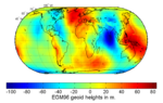
Geoid (redirect from Reference geoid)
position, the height of the geoid (e.g., the EGM96 geoid) over the World Geodetic System (WGS) ellipsoid. They are then able to correct the height above the...
29 KB (3,445 words) - 22:18, 8 January 2025

Gravity of Earth (category Articles needing additional references from September 2024)
1970. If the terrain is at sea level, we can estimate, for the Geodetic Reference System 1980, g { ϕ } {\displaystyle g\{\phi \}} , the acceleration at latitude...
31 KB (3,808 words) - 11:49, 12 February 2025
Augmentation System (WAAS) is an air navigation aid developed by the Federal Aviation Administration to augment the Global Positioning System (GPS), with...
42 KB (4,012 words) - 07:05, 30 January 2025
The Global Area Reference System (GARS) is a standardized geospatial reference system developed by the National Geospatial-Intelligence Agency (NGA) for...
3 KB (470 words) - 12:54, 13 December 2022
Physical geodesy (category Articles needing additional references from October 2021)
poids; valeur conventionnelle de gn. Moritz, Helmut (2000). "Geodetic Reference System 1980". Journal of Geodesy. 74 (1): 128–133. doi:10.1007/s001900050278...
6 KB (1,403 words) - 09:42, 22 September 2024
Geopotential (category Articles needing additional references from July 2014)
revolution called the reference ellipsoid. The currently most widely used reference ellipsoid, that of the Geodetic Reference System 1980 (GRS80), approximates...
12 KB (1,681 words) - 20:05, 9 August 2024
Space geodesy (redirect from Space geodetic)
1969 GRS 80 Geodetic Reference System 1980 ISO 6709 Geographic point coord. 1983 NAD 83 North American Datum 1983 WGS 84 World Geodetic System 1984 NAVD...
471 bytes (50 words) - 09:45, 23 May 2022
BeiDou (redirect from Compass navigation system)
Navigation Satellite System (BDS; Chinese: 北斗卫星导航系统; pinyin: běidǒu wèixīng dǎoháng xìtǒng) is a satellite-based radio navigation system owned and operated...
67 KB (5,801 words) - 19:34, 22 February 2025
reference ellipsoid for Earth is small, only about one part in 300. Historically, flattening was computed from grade measurements. Nowadays, geodetic...
25 KB (2,927 words) - 04:41, 19 February 2025
Galileo (satellite navigation) (redirect from Galileo satellite navigation system)
clocks also generate a worldwide time reference called Galileo System Time (GST), the standard for the Galileo system and are routinely compared to the local...
109 KB (10,787 words) - 00:31, 22 February 2025