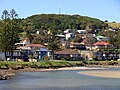
Gerroa is a coastal town in the Municipality of Kiama, in the Illawarra region of New South Wales, Australia 133 kilometres south of Sydney. It is considered...
9 KB (931 words) - 14:30, 24 July 2024
New South Wales South Coast, located 143 km (89 mi) south of the state capital, Sydney. It has many historical buildings which are listed on the New South...
14 KB (1,651 words) - 03:16, 24 January 2024

local government areas that comprise the Wollongong Metropolitan Area, New South Wales, Australia. Although it is surrounded by a 'green belt' of farms, Albion...
8 KB (849 words) - 09:47, 20 July 2024

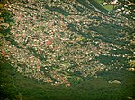
located about ten minutes drive south of Kiama, and about twenty minutes north of Nowra in the Illawarra region of New South Wales, Australia in the Municipality...
25 KB (2,464 words) - 00:33, 2 September 2024
Balgownie (/bælɡaʊni/) is a small suburb of Wollongong, New South Wales, Australia. Balgownie lies to the north-west of the Wollongong CBD. It stretches...
4 KB (275 words) - 10:26, 20 July 2024
Warrawong is a suburb of Wollongong in the Illawarra region of New South Wales, Australia. It is situated on the northeast corner of Lake Illawarra. Warrawong...
4 KB (259 words) - 23:42, 22 August 2024

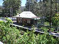
Illawarra region of New South Wales, Australia, in the Municipality of Kiama. It has a station (opened 1891) on the NSW TrainLink South Coast Line. The Minnamurra...
4 KB (351 words) - 13:58, 29 July 2024

contains a mixture of small rural properties and family homes. It has a New South Wales Rural Fire Service station and a small community hall where the Wongawilli...
3 KB (163 words) - 15:55, 30 July 2024
In the state of New South Wales, Australia, there are many areas which are commonly known by regional names. Regions are areas that share similar characteristics...
27 KB (1,851 words) - 19:39, 5 June 2024

Dapto is a suburb of Wollongong in the Illawarra region of New South Wales, Australia, located on the western side of Lake Illawarra and covering 7.15...
16 KB (1,715 words) - 03:18, 12 August 2024
YOU-nən-derr-ə) is a suburb of Wollongong in New South Wales, Australia. It is located approximately 6 km south-west of the Wollongong CBD. It is bordered...
4 KB (400 words) - 14:47, 30 July 2024
Australia and Broken Hill, an ambitious scheme for treating nickel from New Caledonia came to nothing and in 1905 the works closed. (McDonald, 1976;...
5 KB (666 words) - 12:24, 29 July 2024

BULL-eye) is a northern suburb of Wollongong situated on the south coast of New South Wales, Australia. Bulli is possibly derived from an Aboriginal word...
12 KB (1,523 words) - 23:56, 26 August 2024
Koonawarra is a suburb of Wollongong, New South Wales, Australia. It is located on the western shore of Lake Illawarra. Koonawarra, or Exmouth, as it...
2 KB (134 words) - 13:11, 29 July 2024

village of Wollongong on the south coast of New South Wales, Australia. It sits in the northern Illawarra region, south of Stanwell Park and immediately...
8 KB (694 words) - 09:54, 20 July 2024

Saddleback Mountain is a mountain near Kiama in the Illawarra region of New South Wales, Australia. The mountain rises to about 600 metres (2,000 ft) above...
5 KB (506 words) - 09:17, 1 April 2022

narrow area separating it from Dapto, and farmland to the north, west and south. West of Horsley is Mount Bong Bong, part of the Illawarra escarpment range...
3 KB (294 words) - 05:47, 25 May 2024
Lilyvale is a locality in New South Wales in the Royal National Park, south of Sydney. Most of the locality is now in the Royal National Park and Garawarra...
5 KB (513 words) - 13:48, 29 July 2024

New South Wales State Heritage Register. Department of Planning & Environment. H01269. Retrieved 18 May 2018. Text is licensed by State of New South Wales...
32 KB (4,111 words) - 10:40, 30 July 2024

Gwynneville is an inner city suburb of Wollongong, New South Wales, Australia located approximately 2 km north-west of the city centre. It was originally...
3 KB (233 words) - 11:34, 29 July 2024

Figtree is an inner western suburb of Wollongong, New South Wales, Australia. It is south-west of West Wollongong and connected to Wollongong by the Princes...
7 KB (771 words) - 01:10, 15 August 2024

the Illawarra region of New South Wales, Australia. It is located two kilometres from the Princes Highway, 20 kilometres south west of Kiama. Broughton...
5 KB (419 words) - 04:42, 24 July 2024
28 June 2022. "Brownsville". Geographical Names Board of New South Wales. New South Wales Government. Retrieved 17 July 2017. "Suburb Profiles: Brownsville"...
2 KB (114 words) - 14:40, 21 March 2023
Berkeley is a suburb of Wollongong, New South Wales. The suburb is located in Wollongong's southern suburbs, on the northern shore of Lake Illawarra,...
6 KB (591 words) - 13:32, 20 July 2024

kilometres (11 mi) north of Wollongong along the Princes Highway in New South Wales, Australia. It is part of the City of Wollongong and lies between Wombarra...
4 KB (369 words) - 15:57, 21 July 2024
Tarrawanna is a northern suburb of Wollongong, New South Wales, Australia, extending westward from the Princes Highway over the Illawarra Escarpment....
3 KB (188 words) - 08:13, 30 July 2024

Clifton is a village on the coast of New South Wales, Australia, between Sydney and Wollongong. Along with nearby Coalcliff, the village began life as...
6 KB (662 words) - 15:50, 21 July 2024

Windang is a suburb of Wollongong in New South Wales on the southern tip of the peninsula guarding the ocean entrance to Lake Illawarra. Windang is popular...
4 KB (303 words) - 16:07, 30 July 2024
village in the Otford Valley located 55 km south of the Sydney and 30 km north of the Wollongong CBD in New South Wales, Australia. Otford is within the local...
7 KB (905 words) - 15:14, 29 July 2024

Keira about four kilometres northwest from the city of Wollongong, New South Wales, Australia. It is also the name of the road which crosses the nearby...
2 KB (82 words) - 14:02, 29 July 2024