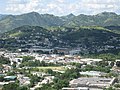
Cayey (Spanish pronunciation: [kaˈʝej]), officially Cayey de Muesas, is a mountain town and municipality in central Puerto Rico located on the Sierra...
49 KB (4,710 words) - 23:20, 12 August 2024

Guavate is a barrio in the municipality of Cayey, Puerto Rico. Its population in 2010 was 1,870. Guavate was in Spain's gazetteers until Puerto Rico was...
9 KB (567 words) - 18:46, 30 December 2023

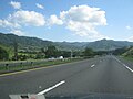
Puerto Rico Highway 52 by municipality Heading south in Cayey Heading north between Salinas and Cayey Heading north near Santa Isabel PR-52 is Puerto...
21 KB (1,126 words) - 17:28, 10 May 2024
in the municipality of Cayey, Puerto Rico. Its population in 2010 was 3,027. Beatriz was in Spain's gazetteers until Puerto Rico was ceded by Spain in...
7 KB (414 words) - 15:18, 27 December 2023

Bacardi Cathedral of Rum and boardwalk in Cataño, the "Pork Highway" of Guavate in Cayey, the bioluminiscent bay in Fajardo, the beaches and street food of...
162 KB (15,542 words) - 12:15, 17 August 2024

part of the Sierra de Cayey mountain system. Other elevations are the mountains Garau, Charcas and Peña Hendida. Parts of the Guavate-Carite Forest and the...
53 KB (4,974 words) - 03:27, 15 August 2024

of the central town of Cidra, merely off the border with Cayey; the exit from PR-52 to Guavate is less than 1 hectometer from the town, and going north...
23 KB (755 words) - 06:38, 2 May 2024
Ruta Panorámica (redirect from Puerto Rico Highway 7718)
of Cayey (Northbound) PR-184 Municipality of Cayey (Southbound) Landmark: Carite State Forest, Guavate PR-7740 Municipalities of San Lorenzo and Patillas...
25 KB (907 words) - 06:05, 22 November 2023

Vuelta Villa Pesquera Beach Lago de Patillas Guavate Forest and places to eat on the boundary with Cayey Patillas celebrates its patron saint festival...
33 KB (2,804 words) - 23:20, 16 August 2024

Hurricane Fiona (redirect from 2022 Puerto Rico floods)
approached Puerto Rico two days later. A few hours afterward, the eye of Fiona made landfall along the southwestern coast of Puerto Rico, near Punta...
73 KB (6,739 words) - 03:10, 5 July 2024

Puerto Rico Highway 184 (PR-184) is a main, rural highway that connects Patillas to Cayey, Puerto Rico, with plans to be extended to Cidra. It extends...
7 KB (312 words) - 01:54, 6 February 2024
a church was built in Cayey, Puerto Rico, called the Guavate Mennonite Church, replacing a smaller structure of the Guavate Mennonite Church which was...
25 KB (2,778 words) - 22:31, 15 June 2024

Puerto Rico Highway 179 (PR-179) is a rural road that travels from Guayama to Cayey in Puerto Rico. It goes through Patillas but with no major junctions...
4 KB (130 words) - 03:03, 1 August 2023

September 19–21, 2017, Hurricane Maria devastated the entire island of Puerto Rico and caused a major humanitarian crisis. Originally as a powerful Category...
116 KB (10,561 words) - 02:07, 2 August 2024
In Puerto Rico, there are 78 municipalities and 902 municipio subdivisions made up of 827 barrios and 75 barrios-pueblo. There are also a number of subbarrios...
76 KB (3,116 words) - 10:42, 8 April 2024

Chicharrón (category Puerto Rican cuisine)
chicharrón produced locally, as is the Guavate barrio in the city of Cayey. Chicharrón is a popular ingredient in Puerto Rican rice with added sofrito, pigeon...
16 KB (1,867 words) - 03:21, 15 August 2024

The climate of Puerto Rico in the Köppen climate classification is predominantly tropical rainforest. Temperatures throughout the year are warm to hot...
18 KB (2,043 words) - 20:25, 12 June 2024
of Rum Cataño Boardwalk Cayey Pueblo and its main plaza Arenas Bridge Carite State Forest Cayey Hall of Fame and Sports Guavate and its lechoneras Juana...
42 KB (3,717 words) - 09:06, 19 January 2024

Carite State Forest (category Cayey, Puerto Rico)
forest and nature reserve located in the Sierra de Cayey mountain range in southeastern Puerto Rico. The forest extends over approximately 2,600 hectares...
11 KB (1,127 words) - 15:08, 12 October 2023

Cerro Las Piñas (category Cayey, Puerto Rico)
mountain of the Sierra de Cayey located in the boundary between the municipalities of Caguas and Cayey in central Puerto Rico. The summit is located at...
2 KB (88 words) - 19:15, 14 July 2024

Puerto Rico state forests (Spanish: Bosques estatales de Puerto Rico), sometimes referred to as Puerto Rico Commonwealth forests in English, are protected...
36 KB (2,205 words) - 13:39, 1 August 2024

1928 Okeechobee hurricane (category 1928 in Puerto Rico)
and destructive hurricane of record in Puerto Rico." Along the storm path, the eye passed over Guayama, Cayey, and Aibonito, resulting in a period of...
70 KB (7,943 words) - 04:41, 2 July 2024

Huracanes y tormentas que han afectado a Puerto Rico (PDF) (Report) (in Spanish). Estado Libre Asociado de Puerto Rico, Agencia Estatal para el Manejo de Emergencias...
112 KB (6,404 words) - 16:05, 11 August 2024

Porta Cordillera (category Tourism in Puerto Rico)
culinary-themed route consisting of a stretch of Puerto Rico Highway 184 that traverses the Guavate barrio of Cayey. The route is so called for its numerous restaurants...
15 KB (1,208 words) - 11:47, 5 October 2023