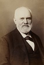
Heinrich Kiepert (July 31, 1818 – April 21, 1899) was a German geographer. Kiepert was born in Berlin. He traveled frequently as a youth with his family...
5 KB (561 words) - 12:56, 27 October 2024
Friedrich Wilhelm August Ludwig Kiepert, German mathematician Heinrich Kiepert, German Geographer Richard Kiepert, German cartographer This disambiguation...
162 bytes (46 words) - 02:59, 29 December 2019

mappings of Jerusalem, initially published in 1841 by German cartographer Heinrich Kiepert as the maps accompanying Biblical Researches in Palestine, the magnum...
10 KB (1,165 words) - 12:32, 12 April 2024

Richard Kiepert (September 13, 1846 – August 4, 1915) was a German cartographer born in Weimar. He was the son of famed geographer Heinrich Kiepert. Richard...
2 KB (226 words) - 20:22, 26 July 2021

labeled R5. Since then several other scholars such as Tasos Neroutsos, Heinrich Kiepert and Ernst von Sieglin placed the tomb in the same area. In 1850, Ambroise...
20 KB (2,180 words) - 17:24, 26 December 2024

name was mentioned in The Histories by Polybius as Ταῦρος (Taûros). Heinrich Kiepert writes in Lehrbuch der alten Geographie that the name was borrowed...
12 KB (1,234 words) - 06:59, 21 December 2024

Arginusae islands (now Garip Islands and Kalem Island). Original map by Heinrich Kiepert (1818–1899) Approaching the Garip Islands in Turkey, by boat from the...
5 KB (439 words) - 20:41, 28 November 2024

the city is the Mohammedan Quarter.' Included was a map, drawn by Heinrich Kiepert, that labelled the four quarters, mirroring Williams's treatment in...
22 KB (2,778 words) - 11:38, 11 January 2025
Kiepert Island (Norwegian: Kiepertøya) is the second-largest of the Bastian Islands in the Svalbard archipelago. It lies east of Wilhelm Island and northeast...
2 KB (224 words) - 19:25, 28 October 2024

the city is the Mohammedan Quarter.' Included was a map, drawn by Heinrich Kiepert, that labelled the four quarters, mirroring Williams's treatment in...
246 KB (23,511 words) - 11:35, 27 January 2025

managed the company upon its founding. Adam Christian Gaspari and Heinrich Kiepert worked there. "Southwest Asia". World Digital Library. 1866. Retrieved...
1 KB (71 words) - 10:45, 4 November 2024

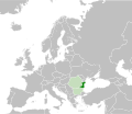
Ethnic composition map of the Balkans by the German geographer and cartographer Heinrich Kiepert in 1882...
41 KB (2,094 words) - 06:11, 23 January 2025

Petermann, Thomas E. Bowdich, William D. Cooley, Heinrich Kiepert, Paul Belloni du Chaillu and Heinrich Barth. Many times he included an outline map of...
86 KB (11,979 words) - 17:13, 29 September 2024

the city is the Mohammedan Quarter.' Included was a map, drawn by Heinrich Kiepert, that labelled the four quarters, mirroring Williams's treatment in...
13 KB (1,517 words) - 06:50, 25 March 2024

Voelker des oestlichen Asien: Studien und Reisen, 1869, Adolf Bastian, Heinrich Kiepert. Ancient geography of India, 1971, Anundoram Borooah. Political History...
40 KB (5,019 words) - 20:30, 23 January 2025

Epiri Aromanian: Epiru Historical region Map of ancient Epirus by Heinrich Kiepert, 1902 Present status Divided between Greece and Albania Demonym Epirote...
75 KB (8,835 words) - 13:39, 19 January 2025

the city is the Mohammedan Quarter.' Included was a map, drawn by Heinrich Kiepert, that labelled the four quarters, mirroring Williams's treatment in...
17 KB (2,014 words) - 16:47, 16 January 2025
south, and their reputation suffered as a result. The 1876 map by Heinrich Kiepert was particularly influential and used at the Congress of Berlin. In...
13 KB (1,144 words) - 14:13, 16 November 2024

the city is the Mohammedan Quarter.' Included was a map, drawn by Heinrich Kiepert, that labelled the four quarters, mirroring Williams's treatment in...
59 KB (6,773 words) - 05:55, 27 January 2025
questioned the authenticity of his writing and stories, including Heinrich Kiepert. His visits to the Zande people were later discovered as being false...
2 KB (241 words) - 00:57, 23 August 2024
"Holy Land cartography reached its zenith with the publication of Heinrich Kiepert's maps and the highly accurate survey of the Palestine Exploration Fund...
43 KB (2,441 words) - 15:43, 16 January 2025

bibliotecavirtual.defensa.gob.es (in German). 1850. Retrieved 2023-05-20. Kiepert, Heinrich (1854). "Karte der Kaukasus-Länder und der angränzenden türkischen...
51 KB (4,462 words) - 19:47, 28 January 2025

Heinrich Kiepert. Asia citerior. Lycaonia, 1903...
8 KB (1,084 words) - 14:48, 22 October 2024

Richard Lepsius visited it in 1840. Both accepted it as Egyptian. Heinrich Kiepert disproved this in 1843 by comparing it with the reliefs of Yazılıkaya...
6 KB (612 words) - 22:24, 12 December 2024
Dobroudja, p. 4, attributes this opinion to Camille Allard, Ami Boué, Heinrich Brunn G. Dănescu, Dobrogea (La Dobroudja). Étude de Géographie physique...
90 KB (9,615 words) - 13:03, 29 January 2025

Ethnic map of Balkans – Heinrich Kiepert 1882...
92 KB (11,330 words) - 17:39, 27 December 2024

composition of Toplica/Morava regions from 1876 with post-1878 borders by Heinrich Kiepert (published 1882) Ethnic composition of Toplica/Morava regions with...
49 KB (5,034 words) - 23:12, 13 December 2024
lesser kestrels on passage migration. The noted German cartographer, Heinrich Kiepert, in his depiction of Crete, committed the space south of the Dionysades...
11 KB (1,089 words) - 21:44, 22 October 2024

Erben in 1868, German cartographer August Heinrich Petermann in 1869, renowned German geographer Heinrich Kiepert in 1876, British mapmaker Edward Stanford...
79 KB (9,304 words) - 19:51, 26 January 2025