
The Hohgant is a mountain of the Emmental Alps, located south of the Emmental in the canton of Bern. The main summit has an elevation of 2,197 metres...
2 KB (117 words) - 09:06, 25 April 2024

Siebenhengste-Hohgant-Höhle is a cave located in Switzerland, near Interlaken in the Canton of Bern north of Lake Thun, between the villages of Eriz and...
4 KB (317 words) - 21:53, 14 July 2024

Retrieved 2020-02-20.. Philipp Häuselmann (2016). Le karst Siebenhengste-Hohgant-Schrattenfluh : essai d'une synthèse (PDF) (in German and French). Vol...
16 KB (838 words) - 17:11, 8 August 2024

[ˈɛmə]) is a river in Switzerland. It rises in the Alps between the peaks of Hohgant and Augstmatthorn in the canton of Bern. The Emme is 80 kilometres (50...
2 KB (170 words) - 14:24, 8 September 2024
Retrieved 2020-02-20. Philipp Häuselmann (2016). Le karst Siebenhengste-Hohgant-Schrattenfluh: essai d'une synthèse (PDF) (in German and French). Vol. 66...
29 KB (1,283 words) - 09:03, 1 October 2024
territory of Ukraine (Optymistychna Cave), Switzerland (Hölloch, Siebenhengste-Hohgant-Höhle) and Spain's (Sistema del Alto). It is the 14th longest cave system...
7 KB (742 words) - 19:52, 8 August 2024
significant elevation of the Bernese Oberland, with the Gemmenalphorn and the Hohgant at the other end, separated by a small valley from the Harder on its southeast...
17 KB (2,246 words) - 17:12, 6 September 2024

summits of which the highest (1,955 metres) is named Chibe. Siebenhengste-Hohgant-Höhle List of mountains of Switzerland Swisstopo maps Sieben Hengste on...
1 KB (51 words) - 22:16, 3 May 2022

46.35222°N 6.81361°E / 46.35222; 6.81361 Chablais Alps Valais 358 99 Hohgant 2,197 7,208 638 2,093 46°47′17″N 07°54′07″E / 46.78806°N 7.90194°E /...
112 KB (1,337 words) - 21:15, 20 July 2024
a list of caves in Switzerland. Grotte aux Fées Hölloch Cave (second longest cave in Europe) Siebenhengste-Hohgant-Höhle St. Beatus Caves Wildkirchli...
416 bytes (25 words) - 03:59, 7 March 2022
the Zulg river, on the south flank of the Honegg and west flank of the Hohgant. It is divided into Ausser- and Inner-Eriz. Ausser-Eriz (Outer Eriz) includes...
20 KB (2,322 words) - 23:25, 22 March 2024
Cave Grotte aux Fées Hölloch Saint-Léonard underground lake Siebenhengste-Hohgant-Höhle St. Beatus Caves Wildkirchli Akhayat sinkhole Ayvaini Cave Ballıca...
69 KB (5,516 words) - 23:29, 27 September 2024

castles'), German for Transylvania, historical region in Romania Siebenhengste-Hohgant-Höhle ('seven male horses'), cave in Switzerland Siebenhirten ('seven shepherds')...
26 KB (2,774 words) - 17:19, 24 September 2024

only 14% were in industry. The Kemmeribodenbad Inn at the foot of the Hohgant opened in 1835 and provided the start of a small tourism industry. Schangnau...
23 KB (2,524 words) - 23:32, 22 March 2024

Honegg Honegg on the left, Hohgant behind Highest point Elevation 1,546 m (5,072 ft) Prominence 356 m (1,168 ft) Parent peak Hohgant Coordinates 46°48′13″N...
1 KB (39 words) - 13:43, 7 May 2022
I/B-08.V-A Savoie FR 1349 Hohgant 2197 636 46°47′17″N 07°54′06″E / 46.78806°N 7.90167°E / 46.78806; 7.90167 (1349. Hohgant (2197 m)) Emmental Alps I/B-14...
89 KB (462 words) - 21:49, 19 January 2024
part) 1977 1996/98 Vaud, Valais 1504 Vanil Noir 1977 Fribourg, Vaud 1505 Hohgant 1977 Bern 1506 Chaltenbrunnenmoor-Wandelalp 1977 1996 Bern 1507/1706 Berner...
17 KB (273 words) - 07:40, 14 September 2022

(2,350 m) Tannhorn (2,221 m) Arnihaaggen (2,207 m) Höch Gumme (2,205 m) Hohgant (2,197 m) Augstmatthorn (2,137 m) Pilatus (2,128 m) Schrattenfluh (2,092...
3 KB (236 words) - 19:17, 1 April 2022
Highest point Elevation 1,118 m (3,668 ft) Prominence 413 m (1,355 ft) Parent peak Hohgant Coordinates 46°55′56″N 7°41′45″E / 46.93222°N 7.69583°E / 46.93222;...
1 KB (43 words) - 18:35, 14 May 2022
77472°N 7.98444°E / 46.77472; 7.98444 Emmental Alps Interlaken-Oberhasli Hohgant 2197 638 46°47′17″N 07°54′07″E / 46.78806°N 7.90194°E / 46.78806; 7...
27 KB (312 words) - 06:35, 6 May 2024

which flows from the Hohngant massif. Underground is the Siebenhengste-Hohgant-Höhle, a karst cave system. On 31 December 2009, Amtsbezirk Interlaken...
18 KB (2,013 words) - 22:55, 22 March 2024
karstification than the overlying Schrattenkalk. In the Siebenhengste-Hohgant-Höhle cave system in Switzerland, large galleries, easily developing in...
2 KB (220 words) - 21:06, 13 December 2023
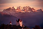
the south Linden (BE) – Village centre with the church, the Stauffen and Hohgant mountains from the north-northwest Linden (BE) – Grafenbuehl, a rural half-timbered...
20 KB (2,329 words) - 23:26, 22 March 2024