
Sherwood South Kempsey West Kempsey Yarravel Towns and localities in the Kempsey Shire are: Kempsey East Kempsey South Kempsey West Kempsey Aldavilla Arakoon...
16 KB (1,041 words) - 10:17, 18 September 2024

Kempsey is a town in the Mid North Coast region of New South Wales, Australia and is the council seat for Kempsey Shire. It is located roughly 16.5 kilometres...
33 KB (3,286 words) - 06:03, 6 September 2024
the mayoral election. Both Williams and Cecato are Nationals members. Kempsey Shire Council is composed of eight councillors elected proportionally to a...
55 KB (1,984 words) - 06:43, 6 October 2024
Kempsey may refer to the following places: Kempsey, New South Wales, Australia Kempsey, Worcestershire, England Kempsey Shire, a local government area...
206 bytes (59 words) - 19:52, 21 February 2024

town on the Mid North Coast, 340 km north-northeast of Sydney, in The Kempsey Shire local government area of New South Wales, Australia. At the 2021 census...
12 KB (1,020 words) - 23:59, 13 August 2024

the City of Coffs Harbour, the Bellingen Shire, the Kempsey Shire, the Mid-Coast Council, the Nambucca Shire and the Port Macquarie-Hastings Council....
9 KB (627 words) - 17:30, 17 August 2024

Bellbrook, New South Wales (category Kempsey Shire)
Bellbrook is a locality in the Kempsey Shire of New South Wales, Australia along the Macleay River. The mountain village is classified by the National...
23 KB (2,212 words) - 18:36, 7 April 2024
of Kempsey, New South Wales, Australia. The airport is operated by Kempsey Shire Council and is mainly used for general aviation activities, including...
12 KB (1,277 words) - 07:40, 13 November 2023

South West Rocks, New South Wales (category Kempsey Shire)
the mouth of the Macleay River. It is approximately 40 km (25 mi) from Kempsey. Jerseyville is located nearby. The population of South West Rocks is 5...
21 KB (1,527 words) - 17:36, 16 May 2024

Kijas & Kelly 2013. NSWP 2015. Carrai 2008. Clybucca 2007, pp. 1, 3, 6. Kempsey Shire heritage. Harrison 2004, p. 64. Harrison 2004, p. 66. Harrison 2004...
18 KB (1,660 words) - 03:54, 22 August 2024

March 2013. "The nature of flooding in the Kempsey Shire" (PDF). Kempsey Shire Local Flood Plan. Kempsey Shire Council. November 2011. Archived from the...
12 KB (1,009 words) - 01:21, 25 February 2024

Trial Bay Gaol (category Kempsey Shire)
public works prison and internment camp at Cardwell Street, Arakoon, Kempsey Shire, New South Wales, Australia. The property is owned by the NSW National...
43 KB (6,381 words) - 22:35, 21 February 2024
South Kempsey is a suburb of Kempsey in the Kempsey Shire, New South Wales, Australia. They are separated by the Macleay River. The 2016 census listed...
2 KB (133 words) - 00:49, 31 January 2024

in the hinterland behind Kempsey, New South Wales is a civil parish of Dudley County. and rural locality in the Kempsey Shire Council Area of the midnorth...
750 bytes (85 words) - 01:28, 22 July 2020
The shire offices were in West Kempsey. Other towns in the shire included Bellbrook, Frederickton, Smithtown and South West Rocks. Macleay Shire was amalgamated...
2 KB (172 words) - 13:52, 13 July 2023

Aboriginal Boys' Training Home at 2054 South West Rocks Road, Kinchela, Kempsey Shire, New South Wales, Australia. It was built from 1924 to 1970. It was...
37 KB (5,139 words) - 15:49, 4 June 2024

of the installed floodgates during small flood events. Part of the Kempsey Shire, Hat Head is a semi-isolated coastal location. It is predominantly a...
3 KB (338 words) - 04:01, 23 January 2024
Dondingalong, New South Wales (category Kempsey Shire)
Dondingalong is a locality in the Kempsey Shire of New South Wales, Australia. It had a population of 664 as of the 2016 census. The Dondingalong Bush...
5 KB (377 words) - 00:52, 31 January 2024
Deep Creek, New South Wales (category Kempsey Shire)
Deep Creek is a locality in Kempsey Shire in New South Wales, Australia. It lies about 20 km west of Kempsey on the road to Armidale and 450 km northeast...
2 KB (77 words) - 12:51, 13 March 2021

heritage-listed former pilot station at 5 Ocean Drive, South West Rocks, Kempsey Shire, New South Wales, Australia. It was built in 1902 by C. B. Smith. It...
22 KB (3,221 words) - 13:11, 14 July 2022

Smoky Cape (category Kempsey Shire)
Smoky Cape is a headland in Australia on the New South Wales Mid-North Coast. It lies just east of the town of South West Rocks, and within the Hat Head...
4 KB (376 words) - 05:58, 9 January 2024
Retrieved 11 June 2022. "Macleay fire update: Carrai East fire north west of Kempsey continues to burn". Macleay Argus. 9 December 2019. Retrieved 25 January...
55 KB (1,686 words) - 04:44, 15 August 2024
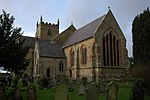
Kempsey is a village and civil parish in the Malvern Hills District in the county of Worcestershire, England. It is bounded by the River Severn on the...
17 KB (2,255 words) - 22:46, 16 April 2024
Kinchela, New South Wales (category Kempsey Shire)
2054 South West Rocks Road: Kinchela Aboriginal Boys' Training Home "Kempsey Shire Heritage: Kinchela". Archived from the original on 12 August 2010. Retrieved...
5 KB (598 words) - 17:43, 2 January 2024
Battalion for six months, and became an alderman of Kempsey Shire Council in 1954. He was Mayor of Kempsey in 1959. Active in the Labor Party, he was elected...
1 KB (147 words) - 04:23, 20 January 2022

"Renaming of the Pacific Highway following completion of the Kempsey Bypass" (PDF). Kempsey Shire Council. 21 August 2012. Archived (PDF) from the original...
138 KB (8,660 words) - 04:08, 14 September 2024
Retrieved 7 July 2017. Australian Bureau of Statistics (27 June 2017). "Kempsey (A)". 2016 Census QuickStats. Retrieved 7 July 2017. Australian Bureau...
52 KB (2,825 words) - 08:12, 19 June 2024

church hall, that is now a retail store, located at 67 Smith Street, Kempsey, Kempsey Shire, New South Wales, Australia. It was built from 1890. It was added...
10 KB (763 words) - 02:46, 10 May 2024

Sutherland Shire is a local government area (LGA) in the southern region of Sydney, in the state of New South Wales, Australia. Sutherland Shire is located...
60 KB (5,262 words) - 23:21, 8 October 2024

p. 3. Retrieved 6 August 2017 – via National Library of Australia. "Kempsey Shire Heritage Study" (PDF). Archived (PDF) from the original on 9 March 2017...
148 KB (18,143 words) - 12:04, 8 August 2024