
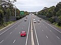
King Georges Road is a 9.0-kilometre-long (5.6 mi) major suburban arterial road through south-western Sydney, Australia. It is a constituent part of the...
12 KB (931 words) - 06:28, 13 August 2024
between Fairford Road and King Georges Road New tolled motorway between King Georges Road and General Holmes Drive at Mascot, adjacent to Sydney Airport, including...
39 KB (3,761 words) - 06:10, 13 August 2024
Wiley Avenue and King Georges Road. It is a major connector between most of the major radial routes emanating from central Sydney, and a major link between...
27 KB (2,195 words) - 15:19, 15 July 2024

Beverly Hills, New South Wales (redirect from Beverly Hills, Sydney)
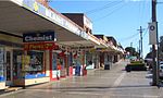
on King Georges Road, near the Beverly Hills railway station. There are over 40 different cafes, restaurants and takeaways along King Georges Road featuring...
10 KB (959 words) - 18:02, 3 August 2024

The Sydney Orbital Network is a 110 kilometre motorway standard ring road around and through Sydney, the capital of New South Wales in Australia. It runs...
8 KB (581 words) - 16:32, 22 March 2024
Narwee, New South Wales (category Georges River Council)
Narwee is Broadarrow Road, which runs from King Georges Road in Beverly Hills to just past Bonds Road in Riverwood. Broadarrow Road is also the boundary...
7 KB (831 words) - 17:04, 26 September 2024

of George Street turning westwards, leading to the western suburbs as Parramatta Road. The origins of George Street lie in the layout of the Sydney Cove...
20 KB (1,810 words) - 12:07, 29 May 2024

Publishers, Sydney, p. 130. "Georges River Council – Home". www.georgesriver.nsw.gov.au. Archived from the original on 17 March 2011. "Georges River Council...
23 KB (2,473 words) - 09:57, 6 October 2024
Penshurst, New South Wales (category Georges River Council)
the Sydney Trains network. It is approximately 27 minutes from Sydney Central via train. The main roads through Penshurst are King Georges Road and Forest...
8 KB (967 words) - 08:24, 4 October 2024

Georges Hall within the City of Canterbury-Bankstown Georges Hall, a suburb of local government area City of Canterbury-Bankstown, is located 24 kilometres...
9 KB (979 words) - 12:25, 30 September 2024
King Street is the central thoroughfare of the suburb of Newtown in Sydney, Australia. The residents of the area, including a higher-than-average concentration...
9 KB (790 words) - 03:00, 16 January 2024

Georges Head Battery, also called the Georges Head Military Fortifications, is a heritage-listed former military fortification located on the Georges...
21 KB (2,209 words) - 01:20, 25 August 2024

The King George V Memorial Hospital for Mothers and Babies is a former hospital, exclusively for mothers and babies, in Sydney, Australia. It is located...
4 KB (339 words) - 07:54, 30 May 2024
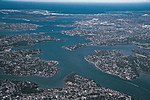
The Georges River, also known as Tucoerah River, is an intermediate tide-dominated drowned valley estuary, that is located in Sydney in the state of New...
21 KB (1,721 words) - 06:38, 30 May 2024

Australian Roads portal Geography of Sydney KML file (edit • help) Template:Attached KML/King Street, Sydney KML is from Wikidata Gregory's Sydney Street...
3 KB (191 words) - 06:59, 3 January 2024

Newtown, New South Wales (redirect from Newtown, Sydney)
the University of Sydney and extends to the south, becoming the Princes Highway at its southern end. Enmore Road branches off King Street towards the...
77 KB (8,476 words) - 22:19, 3 October 2024

Wiley Park, New South Wales (category Suburbs of Sydney)
is bounded by King Georges Road, Canterbury Road, Clio Street and Edge Street. A small shopping strip is located on King Georges Road, near the Wiley...
7 KB (774 words) - 02:08, 20 May 2024
WestConnex (redirect from Sydney Motorway Corporation)
the M4 – completed in July 2019 Stage 2 M5 Interchange at King Georges Road (King Georges Road Interchange) upgrade – completed in December 2016 M8 Tunnel...
94 KB (9,357 words) - 00:20, 5 October 2024
direction until it reaches The River Road in Revesby, where it changes name again to Canterbury Road, meeting King Georges Road at Roselands. At Hurlstone Park...
14 KB (929 words) - 01:56, 9 September 2024

Sans Souci, New South Wales (redirect from Sans Souci, Sydney)
over the Georges River. Sans Souci is a French term meaning "without care", in other terms, "no worries". The area between Cooks River and Georges River...
9 KB (908 words) - 11:18, 27 September 2024

Sydney Sweeney (born September 12, 1997) is an American actress. She first gained attention in 2018 for appearing in the television series Everything Sucks...
63 KB (3,957 words) - 11:12, 10 October 2024

Allawah, New South Wales (redirect from Allawah, Sydney)
became known as Townson's Farm. The grant extended from King Georges Road and Stoney Creek Road (of modern-day Penshurst and Beverly Hills) to beyond Kogarah...
6 KB (577 words) - 18:34, 1 August 2024

Blakehurst, New South Wales (category Georges River Council)
Highway near the intersection with King Georges Road. Commercial developments also extend north along these two main roads. A bus service runs between Hurstville...
6 KB (645 words) - 01:19, 22 August 2024

Southern district of Sydney includes the suburbs in the local government areas of the Georges River Council (collectively known as St George) and the Sutherland...
284 KB (24,917 words) - 19:21, 9 October 2024

Croydon Park, New South Wales (category Suburbs of Sydney)
to the north. Croydon Park has a commercial shopping strip along Georges River Road and is in proximity to larger shopping and town centres of Burwood...
19 KB (1,548 words) - 17:58, 9 August 2024

Balgowlah in Sydney Road near Wanganella Street; at Brookvale from a line in Alfred Road short of Federal Parade; and at Narrabeen near King Street. Various...
120 KB (15,881 words) - 22:49, 10 August 2024
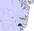
Georges River Council is a local government area located in the St George region of Sydney located south of the Sydney CBD, in New South Wales, Australia...
33 KB (2,637 words) - 06:27, 7 September 2024

Kingsgrove (category Georges River Council)
City of Canterbury-Bankstown, Bayside Council and the Georges River Council. Governor Philip King granted 500 acres (2 km2) in 1804 to Hannah Laycock (1758–1831)...
9 KB (957 words) - 11:48, 26 September 2024
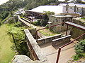
England in 1788 and arrived in what is now Sydney Harbour. The Georges Head Battery located in Georges Heights was constructed in 1871. A naval depot...
2 KB (202 words) - 12:16, 30 January 2024

Hospital, Concord Dental Hospital of Sydney, Elizabeth Street, Surry Hills King George V Memorial Hospital, Missenden Road, Camperdown St Margaret's Hospital...
14 KB (1,667 words) - 11:26, 21 February 2024