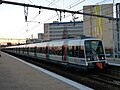
The MI 79 (French: Matériel d'Interconnexion de 1979, English: interconnection rolling stock of 1979), also known as the Class Z 8100 is a dual-voltage...
14 KB (1,501 words) - 02:50, 16 December 2023
Farm-to-Market Roads 355 and 356, 14 mi (23 km) southwest of Groveton, 49 mi (79 km) southwest of Lufkin, and 30 mi (48 km) northeast of Huntsville in southwestern...
3 KB (131 words) - 17:18, 6 August 2024
Pine River Township, Michigan (redirect from Pine River Township, MI)
households, and 704 families residing in the township. The population density was 79.8 inhabitants per square mile (30.8/km2). There were 983 housing units at...
6 KB (551 words) - 21:43, 28 April 2024

Crespin factory between 1985 and 1990. The design of the MI 84 was derived from the earlier MI 79 built for the RER B, but with modifications to make it...
15 KB (1,505 words) - 14:10, 23 March 2024

followed by the MS 61 in 1967, MI 79 in 1980, MI 84 and Z 8800 in 1985, Z 20500 in 1988, MI 2N in 1996, Z 20900 in 2001, MI 09 on 5 December 2011, Z 50000...
32 KB (3,481 words) - 18:04, 26 November 2024

Madison Charter Township, Michigan (redirect from Madison Charter Township, MI)
U.S. Census Bureau, the township has a total area of 30.65 square miles (79.38 km2), of which 30.39 square miles (78.71 km2) is land and 0.26 square miles...
10 KB (907 words) - 05:47, 9 January 2025
Fruitport Charter Township, Michigan (redirect from Fruitport Charter Township, MI)
the U.S. Census Bureau, the township has a total area of 30.4 square miles (79 km2), of which 30.0 square miles (78 km2) are land and 0.4 square miles (1...
9 KB (722 words) - 05:44, 9 January 2025

Meridian Charter Township, Michigan (redirect from Meridian Charter Township, MI)
total area of 31.57 square miles (81.8 km2), of which 30.49 square miles (79.0 km2) is land and 1.08 square miles (2.8 km2) (3.42%) is water. The Red Cedar...
12 KB (1,062 words) - 05:47, 9 January 2025
Hastings Charter Township, Michigan (redirect from Hastings Charter Township, MI)
States Census Bureau, the township has a total area of 30.5 square miles (79.1 km2), of which 30.0 square miles (77.7 km2) is land and 0.54 square miles...
6 KB (492 words) - 05:45, 9 January 2025

Midland, Michigan (redirect from Midland, MI)
Retrieved April 10, 2013. Trautman, Sherry (December 29, 2020). Travel-Mi.com .travel-mi.com. "Mid-Century Modern Midland – The Mid-Century Modern Architectural...
42 KB (4,069 words) - 05:20, 5 November 2024

Brownstown Charter Township, Michigan (redirect from Brownstown Township, MI)
States Census Bureau, the township has a total area of 30.64 square miles (79.36 km2), of which 8.45 square miles (21.89 km2) (27.58%) are covered by water...
17 KB (1,346 words) - 05:40, 9 January 2025

Clam Lake Township, Michigan (redirect from Clam Lake Township, MI)
the township has a total area of 30.85 square miles (79.90 km2), of which 30.71 square miles (79.54 km2) is land and 0.14 square miles (0.36 km2) (0.45%)...
8 KB (756 words) - 22:13, 29 October 2023

is operated by 117 sets of the MI 79 series and 31 sets of the MI 84 series. These are to be replaced from 2025 by the MI 20 series. Past fleet include...
17 KB (1,463 words) - 15:04, 1 November 2024

Park, 307 km2 (119 sq mi): 48 Phu Ruea National Park, 121 km2 (47 sq mi): 16 Phu Suan Sai National Park, 117 km2 (45 sq mi): 79 There are three wildlife...
21 KB (1,429 words) - 07:04, 31 December 2024

South Arm Township, Michigan (redirect from South Arm Township, MI)
total area of 32.68 square miles (84.64 km2), of which 30.64 square miles (79.36 km2) is land and 2.04 square miles (5.28 km2) (6.24) is water. The township...
10 KB (960 words) - 00:15, 29 April 2024

Bureau, the township has a total area of 30.5 square miles (79 km2) of which 30.5 square miles (79 km2) is land and 0.04 square miles (0.10 km2) (0.07%) is...
8 KB (712 words) - 05:42, 9 January 2025

Bagley Township, Michigan (redirect from Bagley Township, MI)
U.S. Census Bureau, the township has a total area of 30.68 square miles (79.46 km2), of which 28.10 square miles (72.78 km2) is land and 2.58 square miles...
8 KB (752 words) - 03:58, 30 April 2024

M-79 is an east–west state trunkline highway in the central portion of Lower Peninsula of the U.S. state of Michigan. The western terminus is about three...
7 KB (922 words) - 19:18, 25 July 2023

U.S. Route 79 (US 79) is a United States highway in the Southern United States. The route is officially considered and labeled as a north–south highway...
17 KB (1,658 words) - 19:06, 12 November 2024

southeast on the south side of town. Tuscaloosa is 55 mi (89 km) to the northwest, and Montgomery is 49 mi (79 km) to the southeast, both via US-82. Alabama State...
14 KB (1,299 words) - 21:00, 1 November 2024

Bureau, the town has a total area of 30.5 square miles (79.0 km2), of which, 30.5 square miles (79.0 km2) is land and 0.0 square miles (0.0 km2) (0.03%)...
7 KB (520 words) - 01:36, 12 October 2024

Amboy Township, Michigan (redirect from Amboy Township, MI)
U.S. Census Bureau, the township has a total area of 30.64 square miles (79.36 km2), of which 29.96 square miles (77.60 km2) is land and 0.68 square miles...
9 KB (782 words) - 13:07, 11 May 2024

The Savoia-Marchetti SM.79 Sparviero (Italian for sparrowhawk) was a three-engined Italian medium bomber developed and manufactured by aviation company...
88 KB (12,356 words) - 05:09, 6 January 2025

has a total area of 30.7 square miles (80 km2), of which 30.5 square miles (79 km2) is land and 0.2 square miles (0.52 km2) (0.55%) is water. As of the census...
7 KB (541 words) - 15:40, 17 December 2024

"U.S. Census website". United States Census Bureau. Retrieved January 31, 2008. 41°14′30″N 79°56′59″W / 41.24167°N 79.94972°W / 41.24167; -79.94972...
6 KB (453 words) - 05:35, 30 December 2024

56 mi (90 km) (low PRF) versus 26 sq ft (2.4 m2) target. 49 mi (79 km) (high PRF) to 45 mi (72 km) (low PRF) versus 11 sq ft (1 m2) target. AN/MPQ-64 Sentinel...
60 KB (6,913 words) - 02:54, 26 December 2024

States Census Bureau, the township has a total area of 30.8 square miles (79.9 km2), of which 0.01 square miles (0.03 km2), or 0.03%, is water. As of the...
9 KB (746 words) - 11:33, 10 October 2024
a total area of 34.9 square miles (90.4 km2), of which 30.6 square miles (79.3 km2) is land and 4.3 square miles (11.2 km2) (12.35%) is water. As of the...
6 KB (528 words) - 16:53, 15 November 2024

States Census Bureau, the township has a total area of 30.8 square miles (79.7 km2), all land. Taylor Township is bordered by Rush Township to the northwest...
8 KB (578 words) - 05:49, 31 December 2024

Commons has media related to Penn Township, Westmoreland County, Pennsylvania. 40°22′00″N 79°36′59″W / 40.36667°N 79.61639°W / 40.36667; -79.61639...
9 KB (549 words) - 21:58, 28 May 2024