
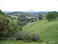
The Mokelumne Wilderness is a 105,165-acre (164 sq mi; 426 km2) federally designated wilderness area located 70 miles (110 km) east of Sacramento, California...
13 KB (846 words) - 09:24, 4 June 2024

The Mokelumne River (/məˈkʌləmni/ or /məˈkʌləmi/; Mokelumne, Miwok for "People of the Fish Net") is a 95-mile (153 km)-long river in northern California...
41 KB (4,105 words) - 08:38, 10 October 2023

Mokelumne Peak is a peak in the Mokelumne Wilderness, Sierra Nevada, Amador County, California, consisting of metamorphic and granitic rock. Mokelumne...
3 KB (298 words) - 15:56, 18 July 2024

summit is the highest point in Eldorado National Forest and the Mokelumne Wilderness. The mountain lies just south of Carson Pass. With 2,541 feet (774 m)...
7 KB (716 words) - 20:54, 1 February 2024
Mokelumne Wilderness, a federally designated wilderness area named after the river Mokelumne Hill, California, a town named after the river The Mokelumne Aqueduct...
493 bytes (99 words) - 16:55, 6 January 2022
worked alone. His most impressive log cabin survives, deep in the Mokelumne Wilderness to this day. Archie Edwin Wright was born on April 20, 1886 in the...
15 KB (1,901 words) - 12:30, 4 May 2024
southwest Sacramento County – west Eldorado National Forest (part) Mokelumne Wilderness (part) † County seat ‡ Data for Amador County area of this CDP †...
50 KB (2,419 words) - 19:56, 25 August 2024

Eldorado National Forest (section Wilderness areas)
steep canyons. The Desolation Wilderness is located within the forest's boundaries, as is most of the Mokelumne Wilderness (which extends into neighboring...
9 KB (826 words) - 07:11, 1 March 2024

County, California, United States. The Nipple is located in the Mokelumne Wilderness of the Sierra Nevada mountain range. The summit is situated 4.5 miles...
5 KB (336 words) - 09:23, 4 November 2023

(partly in Stanislaus NF) Hoover Wilderness (partly in Inyo NF) La Madre Mountain Wilderness (mostly BLM) Mokelumne Wilderness (mostly in Eldorado NF and partly...
12 KB (847 words) - 22:50, 7 June 2024

wildfire that burned 68,637 acres (27,776 ha), primarily in the Mokelumne Wilderness in Alpine County, California, Douglas County, Nevada and Lyon County...
25 KB (2,631 words) - 18:47, 28 March 2024

Sierra Nevada of California, at Lost Lakes near Carson Pass in the Mokelumne Wilderness of Humboldt-Toiyabe National Forest. It flows north into Hope Valley...
4 KB (254 words) - 03:41, 11 May 2020

Truckee Rivers, to Winnemucca Lake in the Mokelumne Wilderness, where it meets the watersheds of the Mokelumne and Carson Rivers. Lands east of the American...
40 KB (4,164 words) - 02:45, 4 September 2024

are also many trailheads located near Caples Lake that enter into Mokelumne Wilderness. The names of the trailheads are Lake Margaret Trailhead, Meiss Lake...
10 KB (904 words) - 00:04, 9 September 2023
The National Wilderness Preservation System includes 806 wilderness areas protecting 111,889,002 acres (174,826.566 sq mi; 452,798.73 km2) of federal land...
171 KB (335 words) - 19:29, 1 September 2024
Round Top is the highest point of Eldorado National Forest and the Mokelumne Wilderness. The summit of Signal Peak is the highest point of the Pine Valley...
166 KB (13,958 words) - 19:07, 19 July 2024

California, United States. This landmark of Hope Valley is set in the Mokelumne Wilderness of the Sierra Nevada mountain range. The summit is situated one mile...
7 KB (610 words) - 06:00, 26 November 2023
36°38′13″N 119°53′49″W / 36.637°N 119.897°W / 36.637; -119.897 in the Mokelumne Wilderness mapped by the USGS in 1889; "however, it may have long been used...
368 KB (34,060 words) - 17:25, 6 September 2024

Peak is set three miles (4.8 km) northwest of Ebbetts Pass in the Mokelumne Wilderness, on the common boundary that Humboldt–Toiyabe National Forest shares...
6 KB (529 words) - 02:17, 6 June 2024

located in the Mokelumne Wilderness on land managed by the Eldorado National Forest. The peak ranks as the fourth-highest in the wilderness and the forest...
5 KB (321 words) - 15:23, 18 July 2024
- Ansel Adams Wilderness". "California Wilderness High Points". Peakbagger.com. Retrieved May 10, 2020. "Wilderness Connect". wilderness.net. "Plumas National...
53 KB (1,282 words) - 05:15, 10 November 2023
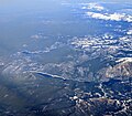
center) are visible in aerial view from the south, with Mokelumne Peak in the Mokelumne Wilderness at the far right. A portion of Lake Tahoe is visible at...
6 KB (307 words) - 16:53, 5 June 2024

Raymond Peak is set 4.5 miles (7.2 km) north of Ebbetts Pass in the Mokelumne Wilderness, on land managed by Humboldt–Toiyabe National Forest. It is situated...
6 KB (511 words) - 13:54, 18 March 2023
Park Round Top (Alpine County, California), the highest peak in the Mokelumne Wilderness Round Top (Contra Costa County, California), an extinct volcano in...
1 KB (211 words) - 11:20, 19 May 2024
03472) Round Top (Alpine County, California), the highest peak in the Mokelumne Wilderness at 10,381 ft (3,164 m) (38°40′N 120°00′W / 38.66°N 120.00°W /...
2 KB (257 words) - 15:42, 19 May 2024

The John Muir Wilderness is a wilderness area that extends along the crest of the Sierra Nevada of California for 90 miles (140 km), in the Inyo and Sierra...
7 KB (566 words) - 22:50, 8 July 2023

Point Reyes National Seashore (redirect from Phillip Burton Wilderness)
above Drake's Bay. About half of the national seashore is protected as wilderness. The Point Reyes peninsula is a well defined area, geologically separated...
41 KB (4,218 words) - 02:23, 9 September 2024

Emigrant Wilderness is located entirely within its boundaries. Portions of the Carson-Iceberg Wilderness, including the Dardanelles Cone, and the Mokelumne Wilderness...
5 KB (427 words) - 20:18, 24 December 2023

almost all of its length, the trail is in the High Sierra backcountry and wilderness areas. For about 160 miles (260 km), the trail is coincident with the...
33 KB (3,235 words) - 08:23, 3 September 2024

Rhizocarpales Rhizocarpon superficiale in Mokelumne Wilderness, California Scientific classification Domain: Eukaryota Kingdom: Fungi Division: Ascomycota...
8 KB (756 words) - 15:23, 27 April 2024