
Mount Hood Village is the name of a census-designated place (CDP) within the Mount Hood Corridor in Clackamas County, Oregon, United States. As of the...
11 KB (695 words) - 16:52, 2 July 2024
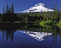
snowfields. It is the highest point in Oregon and the fourth highest in the Cascade Range. Mount Hood is considered the Oregon volcano most likely to erupt, though...
55 KB (4,695 words) - 20:46, 1 July 2024

Oregon, United States, on the base of Mount Hood and north of Tom Dick and Harry Mountain. It is the only town within 5 miles (8 km) of Mount Hood and...
14 KB (636 words) - 23:49, 26 December 2023

The Mount Hood Corridor is a part of Oregon between Sandy and Government Camp, in Clackamas County. It is named after Mount Hood and has served travelers...
3 KB (212 words) - 20:45, 4 October 2023
the mountain Mount Hood Parkdale, Oregon, the name of the post office that serves Mount Hood, Oregon List of ships called HMS Hood Hood Steamer, an early...
4 KB (498 words) - 11:35, 30 September 2023

unincorporated community in Clackamas County, Oregon, United States. It is located within the Mount Hood Corridor between Zigzag and Wemme along U.S. Route...
5 KB (235 words) - 00:40, 4 May 2024
Oregon, United States, served by the Brightwood, Oregon 97011 post office. It is on Mount Hood Highway 26 northwest of Mount Hood Village, Oregon near...
3 KB (63 words) - 01:14, 21 February 2024

the Villages at Mount Hood. A post office was established in the area in 1909 and named "Rowe" after Henry S. Rowe, a mayor of Portland, Oregon who was...
4 KB (211 words) - 23:42, 10 November 2023
become the Villages at Mount Hood, Oregon's first village. From a census perspective these communities are part of the Mount Hood Village CDP. The residents...
6 KB (749 words) - 02:37, 17 May 2024

unincorporated community in Clackamas County, Oregon, United States. It is located within the Mount Hood Corridor, between Rhododendron and Welches on...
8 KB (438 words) - 00:49, 11 November 2023

Brightwood is an unincorporated community within the Mount Hood Corridor in Clackamas County, Oregon, United States. It is located between Wemme and Sandy...
4 KB (200 words) - 20:24, 13 November 2023

the Hood River, just north of the city's historic train depot on the Mount Hood Railroad, where excursion trains depart for Parkdale near Mount Hood. Across...
71 KB (5,595 words) - 00:08, 29 April 2024
Douglas DC-9 aircraft. Mount Hood Village CDP Village (Oregon) U.S. Geological Survey Geographic Names Information System: Wemme, Oregon McArthur, Lewis A...
6 KB (277 words) - 01:05, 11 November 2023

upstream of Portland. Issuing from Reid Glacier on the southwest flanks of Mount Hood in the Cascade Range, the Sandy River flows generally west and then north...
20 KB (2,089 words) - 23:28, 25 November 2022

- Monroe - Monument - Morgan - Moro - Mosier - Mount Angel - Mount Hood - Mount Hood Village - Mount Vernon - Mountain Air Park - Mountain View - Mountaindale...
41 KB (1,679 words) - 04:16, 25 June 2024

serves as the western gateway to the Historic Columbia River Highway, the Mount Hood Scenic Byway, and the Columbia River Gorge. It is approximately 12 miles...
21 KB (2,070 words) - 21:20, 2 May 2024

county's only village is the Villages at Mount Hood. Barlow Canby Estacada Gladstone Happy Valley Johnson City Lake Oswego Milwaukie Molalla Oregon City (county...
39 KB (2,752 words) - 06:49, 25 June 2024

of North America, named Mount Hood in present-day Oregon, and Hood's Canal in present-day Washington, after Hood. Port Hood, Nova Scotia, is also named...
27 KB (2,682 words) - 20:01, 11 April 2024
The Mount Hood Express (formerly Mountain Express Bus) is a transit system serving Mount Hood Corridor communities in Clackamas County, Oregon, U.S. The...
6 KB (437 words) - 03:10, 6 April 2023

base of Mount Hood. The community is approximately 31 miles (50 km) from Government Camp, a major resort and skiing community on Mount Hood. The community...
45 KB (3,998 words) - 12:40, 15 May 2024

Snow Bunny (category Mount Hood National Forest)
121.728156°W / 45.287493; -121.728156 in Mount Hood National Forest on the south face of Mount Hood in Oregon, United States, about 65 miles (105 km) east...
7 KB (778 words) - 13:35, 3 December 2023
Congress. "U.S. OKs Mt. Hood Freeway". The Oregon Journal. January 25, 1969. p. 1. "State To Explain Two Proposals For Route Of Mt. Hood Freeway From Willamette...
18 KB (1,781 words) - 22:42, 29 June 2024

Cascade Mountain Range, the city serves as the western gateway to the Mount Hood Corridor, and is located approximately 27 miles (43 km) east of Portland...
26 KB (2,296 words) - 12:10, 16 June 2024

(also designated the Cascade Locks Highway) Mount Hood Highway No. 26 for three miles (4.8 km) through Hood River Historic Columbia River Highway No. 100...
36 KB (2,200 words) - 22:34, 25 May 2024

Multnomah Falls (redirect from Multnomah Falls, Oregon)
the Columbia River Gorge, east of Troutdale, between Corbett and Dodson, Oregon, United States. The waterfall is accessible from the Historic Columbia River...
24 KB (2,441 words) - 04:28, 3 July 2024

Mount Rainier, the highest of the Cascade volcanoes. Mount Hood, the nearest major volcanic peak in Oregon, is 60 miles (100 km) southeast of Mount St...
85 KB (8,809 words) - 02:27, 24 June 2024

thousand years they created trails over the Cascade Range and around Mount Hood, near the upper part of the Bull Run watershed. By the mid-19th century...
59 KB (6,782 words) - 22:06, 21 January 2024

County, Oregon - southwest Clackamas County, Oregon - west Hood River County, Oregon - west Mount Hood National Forest As of the 2010 census, there were...
20 KB (1,865 words) - 18:46, 26 April 2024

metro area and continues to the Pacific Ocean westward and Mount Hood and Central Oregon eastward. U.S. 30 has a main, bypass, and business route through...
205 KB (18,750 words) - 19:01, 3 July 2024
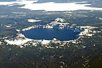
Mount Mazama (Tum-sum-ne in the Native American language Klamath) is a complex volcano in the western U.S. state of Oregon, in a segment of the Cascade...
83 KB (10,741 words) - 10:20, 26 June 2024