
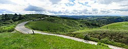
Mount Umunhum (/ˈʌmənʌm/ UH-mə-num) is a peak in the Santa Cruz Mountains, located in Santa Clara County, California. It is the fourth-highest peak in...
12 KB (1,202 words) - 00:50, 15 September 2024

March 21, 2012. Scott Herhold, "Herhold: A story of sacrifice by a Mount Umunhum commander" The Mercury News, March 21, 2012 04:24:39 pm PDT Deborah...
7 KB (757 words) - 17:35, 10 July 2024

California Highway 17. The park features the peaks of Mount Umunhum 3,486 feet (1,063 m), Mount Thayer 3,478 feet (1,060 m), and El Sombroso peak 2,999...
4 KB (455 words) - 19:49, 8 May 2023

Capitancillos Hills of the Sierra Azul are to Almaden's west and south. Mount Umunhum, in the Sierra Azul, is the former site of the Almaden Air Force Station...
58 KB (4,645 words) - 14:54, 3 August 2024
Preserve are closed to the public due to hazardous areas at the summit of Mount Umunhum. In total, the district has 226 mi (364 km) of hiking trails, of which...
8 KB (866 words) - 17:18, 8 July 2024

watershed carries precipitation from the slopes of Loma Prieta and Mount Umunhum, the two major peaks of the Sierra Azul, the historical Spanish name...
33 KB (3,441 words) - 22:16, 13 July 2024

Hills communities, as well as the former Almaden Air Force Station on Mount Umunhum, and Loma Prieta (highest peak in the Santa Cruz Mountains) are also...
15 KB (1,298 words) - 05:29, 12 July 2023
earthquake. Other major peaks include Mount Umunhum at 3,486 feet (1,063 m), Mount Thayer at 3,479 feet (1,060 m), Mount Bielawski at 3,231 feet (985 m), El...
26 KB (2,668 words) - 19:17, 30 May 2024
began in 1874. Hiking and mountain bike trails open to the peak of Mount Umunhum in San Mateo County, a spur of the Bay Area Ridge Trail October Fourteen...
300 KB (27,330 words) - 08:31, 26 August 2024

Loma Prieta Long Ridge Montara Mountain Mount Bielawski Mount Chual Mount Madonna Mount Thayer Mount Umunhum San Bruno Mountain Santa Teresa Hills Twin...
5 KB (451 words) - 16:25, 8 April 2024
9 km) northward-flowing stream originating just east of the peak of Mount Umunhum in Santa Clara County, California, United States. It courses along the...
14 KB (1,437 words) - 13:23, 14 January 2024

Some remains were removed during the construction of the highway. Mount Umunhum (Dove Mountain) is the physical foundation of Tamien Nation oral narrative...
82 KB (10,619 words) - 19:25, 24 September 2024
Loma Prieta Long Ridge Montara Mountain Mount Bielawski Mount Chual Mount Madonna Mount Thayer Mount Umunhum San Bruno Mountain Santa Teresa Hills Twin...
8 KB (879 words) - 16:26, 8 April 2024
Service located north of Reno on Virginia Peak, south of San Jose on Mount Umunhum, and at Beale Air Force Base. On February 12, 2007, KCRA became the...
33 KB (3,973 words) - 18:08, 20 July 2024

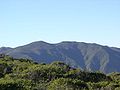
section of the abandoned Almaden Air Force Station, about 1 mile west of Mount Umunhum. The elevation of the summit is at 3,479 feet (1,060 m) feet. An old...
2 KB (143 words) - 00:15, 8 April 2022
elevations are imprecise. The USGS GNIS data lists Mount Diablo's elevation as 3,842 feet (1,171 m). Mount Tamalpais is also listed under GNIS 235989 with...
36 KB (123 words) - 21:39, 2 August 2024

Loma Prieta Long Ridge Montara Mountain Mount Bielawski Mount Chual Mount Madonna Mount Thayer Mount Umunhum San Bruno Mountain Santa Teresa Hills Twin...
4 KB (292 words) - 05:24, 16 July 2023
Mount Tinemaha Mount Tom Mount Tyndall Mount Umunhum Mount Veeder Mount Versteeg Mount Wallace Mount Warlow Mount Warren Mount Whitney, highest summit...
140 KB (11,206 words) - 03:16, 29 September 2024
States Geological Survey, United States Department of the Interior. "Mount Umunhum". Geographic Names Information System. United States Geological Survey...
11 KB (1,094 words) - 00:19, 5 January 2024
Loma Prieta Long Ridge Montara Mountain Mount Bielawski Mount Chual Mount Madonna Mount Thayer Mount Umunhum San Bruno Mountain Santa Teresa Hills Twin...
33 KB (3,565 words) - 10:17, 21 February 2024

in the public domain. Missiles and Rockets, April 17, 1961, p. 50. "Mount Umunhum cube to stay: Cold War relic gets historic designation". San Jose Mercury...
8 KB (1,159 words) - 06:27, 11 August 2024

Mount Bielawski or Mount Bielewski (with an e instead of an a) is located in the Santa Cruz Mountains of California, near the San Francisco Bay Area. The...
3 KB (237 words) - 17:35, 18 July 2024

reservoir is fed by Herbert Creek whose source is just south of the peak of Mount Umunhum. In addition to Herbert Creek, the reservoir has several minor tributaries...
14 KB (1,388 words) - 22:18, 17 February 2024

is within the Sierra Azul Open Space Preserve. The highest peak is Mount Umunhum, the site of the former Almaden Air Force Station radar site and the...
3 KB (247 words) - 20:19, 28 June 2023

Herhold (May 21, 2013). "Herhold: Whatever happened to Zuckerberg, Mt. Umunhum and the Golden Spigot?". mercurynews.com. "Member, City Council; City of...
38 KB (3,319 words) - 04:01, 19 September 2024

Loma Prieta Long Ridge Montara Mountain Mount Bielawski Mount Chual Mount Madonna Mount Thayer Mount Umunhum San Bruno Mountain Santa Teresa Hills Twin...
3 KB (173 words) - 17:55, 6 December 2022

Mt Umunhum 3,486 ft (1,063 m) Loma Prieta 3,790 ft (1,160 m)...
13 KB (1,108 words) - 21:37, 26 May 2024

Mt Umunhum 3,486 ft (1,063 m) Loma Prieta 3,790 ft (1,160 m)...
7 KB (541 words) - 17:12, 3 June 2024