
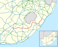
The N10 is a national route in South Africa connecting Gqeberha on the Eastern Cape coast with the Namibian border at Nakop, via Cradock, De Aar and Upington...
6 KB (620 words) - 15:04, 10 September 2024

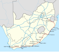
routes in South Africa are a class of trunk roads and freeways which connect major cities. They form the highest category in the South African route numbering...
11 KB (797 words) - 16:47, 10 September 2024
N10 may refer to: N10 (South Africa) N10 highway, Philippines N10 road (Ghana) N10 road (Ireland) Makran Coastal Highway, Pakistan Nebraska Highway 10...
1,003 bytes (174 words) - 05:12, 20 August 2023

Graaff-Reinet, Somerset East and King William's Town. It is cosigned with the N10 between Eastpoort and Cookhouse for 24 kilometres. The R63 begins 20 kilometres...
8 KB (739 words) - 19:17, 10 September 2024

seen from the N10 Gouda Wind Farm just outside the town of Gouda, Western Cape Map all coordinates in "Category:Wind farms in South Africa" using OpenStreetMap...
114 KB (4,176 words) - 04:40, 17 August 2024

Pass and Lootsberg Pass to Middelburg, where it meets the N10 south of the town centre. The N10 joins the N9 to form an eastern bypass around Middelburg...
5 KB (489 words) - 15:03, 10 September 2024
eastern end at a junction with the N10 national route across the river from Upington. Falkner, John (May 2012). South African Numbered Route Description and...
2 KB (207 words) - 22:14, 7 September 2024
going eastwards to form an intersection with the N9 & N10 national route co-signage. From the N9/N10 interchange, the R56 goes eastwards for 75 kilometres...
8 KB (768 words) - 19:15, 10 September 2024

northern terminus. It then passes through Prieskapoort Pass and crosses the N10 to enter Prieska. It leaves the town heading east-north-east. After about...
3 KB (249 words) - 22:11, 7 September 2024
through Askham and Andriesvale. Its southern origin is a junction with the N10 at Upington (north of the city centre), just west of the Upington Airport...
3 KB (243 words) - 22:16, 7 September 2024

The R61 is a long provincial route in South Africa that connects Beaufort West with Port Shepstone via Graaff-Reinet, Komani (previously Queenstown), Mthatha...
11 KB (1,124 words) - 19:16, 10 September 2024
On the other side, it crosses the N10 and on the other side passes through Paterson. From Paterson, it heads south-east to the N2, where it is cosigned...
2 KB (112 words) - 20:50, 5 September 2024

The R48 begins west of the town centre of De Aar, at a junction with the N10 national route. It begins by going eastwards into De Aar's northern suburbs...
4 KB (328 words) - 16:03, 10 September 2024

starts at Groblershoop in the Northern Cape (115 km south-east of Upington) at a junction with the N10. It runs east for 285 km, through Griekwastad, crossing...
6 KB (563 words) - 15:03, 10 September 2024
The N10 road also designated as RN10, is a national route in Central African Republic with a total distance of 134 kilometers. The road provides connection...
3 KB (324 words) - 20:08, 8 August 2024

cities. The N10 national route crosses the N12 500m outside the town. De Aar is the closest big town and lies 50 km East from Britstown on the N10. In 1877...
5 KB (247 words) - 20:05, 26 May 2021

of South Africa. The town is located some 80 kilometres (50 miles) north-west of Alexandria and 21 kilometres (13 miles) north of Nanaga on the N10 National...
6 KB (299 words) - 12:58, 5 February 2024
heads east to Putsonderwater. I then heads south-east to Marydale, where it is briefly co-signed with the N10 heading north. It diverges, again heading...
2 KB (117 words) - 23:00, 7 September 2024

Orange River, to reach Upington. In the town centre, it intersects with the N10 at a staggered junction before continuing north-east to Olifantshoek and...
9 KB (957 words) - 15:13, 10 September 2024

The N12 is a national route in South Africa which runs from George through Beaufort West, Kimberley, Klerksdorp and Johannesburg to eMalahleni. It is the...
20 KB (2,097 words) - 15:13, 10 September 2024

meets the southern terminus of the N10 national route at the same interchange. Falkner, John (May 2012). South African Numbered Route Description and Destination...
5 KB (385 words) - 16:04, 11 September 2024
The N2 is a national route in South Africa that runs from Cape Town through George, Gqeberha, East London, Mthatha, Port Shepstone and Durban to Ermelo...
38 KB (4,041 words) - 12:29, 10 September 2024
The R390 is a Regional Route in South Africa that connects Cradock with Bethulie. It is co-signed with the R56 to Steynsburg for 10 kilometres. Part of...
2 KB (94 words) - 23:08, 7 September 2024

Eastern Cape province of South Africa. Middleton is situated on the banks of the Fish River off the N10 road and is about 30 km south of Cookhouse. Middleton...
6 KB (509 words) - 14:04, 23 February 2024

The border between Namibia and South Africa is 967 kilometres (601 mi) long. It runs along the Orange River from its mouth on the Atlantic Ocean to the...
7 KB (537 words) - 18:32, 29 December 2023
The R398 is a Regional Route in South Africa that connects Middelburg with Britstown via Richmond. The R398 begins in the town centre of Middelburg, Eastern...
2 KB (181 words) - 23:24, 7 September 2024

Toyota Hilux (redirect from Toyota Hilux (N10))
"gentle" 136.1 km/h (84.6 mph) top speed in a period road test conducted in South Africa, in spite of a claimed 89 kW (121 PS; 119 hp). The Hilux was radically...
174 KB (14,349 words) - 21:24, 11 September 2024
The N10 or National Highway 10 is a national highway in Ghana that begins at Kumasi and runs north to Burkina Faso, where it turns into the N5 of Burkina...
2 KB (113 words) - 20:43, 21 July 2024
Olifantskop Pass (category Use South African English from October 2023)
situated in the Eastern Cape province of South Africa. It carries three to four lanes of road traffic on the N10 national road over the Suurberg mountains...
2 KB (155 words) - 17:59, 30 October 2023

The N11 is a national route in South Africa which runs from the Botswana border at Groblersbrug, through Mokopane, Middelburg, Ermelo and Newcastle to...
8 KB (821 words) - 15:12, 10 September 2024