
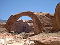
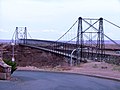
Navajo Bridge is the name of twin steel spandrel arch bridges that cross the Colorado River in the Grand Canyon National Park (near Lees Ferry) in northern...
16 KB (1,576 words) - 01:18, 5 August 2024

The Navajo Nation (Navajo: Naabeehó Bináhásdzo), also known as Navajoland, is an Indian reservation of Navajo people in the United States. It occupies...
114 KB (11,946 words) - 06:16, 30 August 2024

Chevelon Creek Bridge is a historic road bridge located about 12 miles (19 km) southeast of Winslow, in Navajo County, eastern Arizona, United States...
12 KB (1,200 words) - 17:46, 10 June 2023

Navajo Mountain (Navajo: Naatsisʼáán meaning "Earth Head") is a peak in San Juan County, Utah, with its southern flank extending into Coconino County...
7 KB (723 words) - 04:10, 29 June 2024

concrete balanced cantilever bridges are often built using segmental construction. Some steel arch bridges (such as the Navajo Bridge) are built using pure cantilever...
12 KB (1,103 words) - 08:15, 2 August 2024

well known for the Navajo Bridge, where US Highway 89A crosses the Colorado River. Marble Canyon marks the western boundary of the Navajo Nation. In 1975...
4 KB (399 words) - 17:20, 23 January 2024

northeastern part of the strip, and US 89A crosses the Colorado River via the Navajo Bridge, providing the only direct road connection between the strip and the...
10 KB (1,133 words) - 05:40, 27 April 2024

Perrine Bridge—486' Navajo Bridge—470' Moyie River Canyon Bridge—464' Transport portal Engineering portal United States portal List of highest bridges List...
37 KB (1,170 words) - 21:16, 3 August 2024

Antelope Canyon (redirect from Lake Powell Navajo Tribal Park)
primary attraction of Lake Powell Navajo Tribal Park, along with a hiking trail to Rainbow Bridge National Monument. The Navajo name for Upper Antelope Canyon...
13 KB (1,216 words) - 02:17, 15 July 2024

Reddish or vermilion-colored cliffs are found along U.S. Highway 89A near Navajo Bridge, and may be seen from U.S. Highway 89 close to Bitter Springs. Highway...
4 KB (482 words) - 20:48, 17 March 2024

spans A railway bridge with a rail track in Leflore County, Mississippi Chevelon Creek Warren Pony Truss Bridge,Chevelon Creek, Navajo County Arizona built...
51 KB (5,451 words) - 11:51, 21 July 2024
canyons at the feet of Navajo Mountain, Rainbow Bridge was known for centuries by the Native Americans who have long held the bridge sacred. Ancient Pueblo...
13 KB (1,528 words) - 23:35, 13 August 2024

made it an important crossing point before the construction of Navajo and Glen Canyon Bridges in the 20th century. Here, the Colorado River is also much smoother...
34 KB (3,841 words) - 23:12, 18 August 2024
taking U.S. Route 89A from Jacob Lake on the Kaibab Plateau toward Navajo Bridge, turning north onto the House Rock Valley Road, after descending from...
18 KB (2,041 words) - 22:57, 5 January 2024

Mississippi River bridge (1967) bridge that collapsed in 2007 in Minneapolis, Minnesota, USA. Navajo Bridge and newer (1995) bridge of the same general...
3 KB (284 words) - 05:15, 22 January 2024

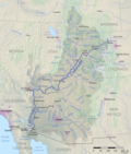
Colorado River (category Articles containing Navajo-language text)
settlements. The Navajo gradually displaced Hopi settlements as they expanded into northern Arizona after the 1500s. Navajo Mountain and Rainbow Bridge in the Glen...
246 KB (23,449 words) - 01:16, 26 August 2024

the Navajo Bridge, Vermilion Cliffs, the Kaibab Plateau, and Fredonia, Arizona. The eastern portion of the highway runs through part of the Navajo Nation...
10 KB (742 words) - 05:04, 25 September 2022
through-truss, with a 14-foot (4.3 m) wide roadway. The bridge was built to improve access to the Navajo Nation and the Hopi Indian Reservation. Named for U...
7 KB (593 words) - 18:22, 24 September 2022

Cantilever (category Bridge components)
roadway or river, or in a deep valley). Therefore, some truss arch bridges (see Navajo Bridge) are built from each side as cantilevers until the spans reach...
18 KB (2,120 words) - 22:29, 28 February 2024

Canyon Bridge or Glen Canyon Dam Bridge is a steel arch bridge in Coconino County, Arizona, carrying U.S. Route 89 across the Colorado River. The bridge was...
4 KB (161 words) - 07:00, 30 November 2023

floors of the new dam. True's design scheme incorporated motifs of the Navajo and Pueblo tribes of the region. Although some were initially opposed to...
93 KB (10,736 words) - 19:31, 28 August 2024

Monument Valley (redirect from Monument Valley Navajo Tribal Park)
Monument Valley (Navajo: Tsé Biiʼ Ndzisgaii, pronounced [tsʰépìːʔ ǹtsɪ̀skɑ̀ìː], meaning "valley of the rocks") is a region of the Colorado Plateau characterized...
17 KB (1,404 words) - 23:49, 24 August 2024

website Proclamation establishing Vermilion Cliffs National Monument USGS Navajo Bridge (AZ) Topo Map National Geographic: Vermilion Cliffs National Monument...
8 KB (666 words) - 00:10, 7 December 2023

placed at Navajo Bridge in 1952. Her plaque at Navajo Bridge was moved to its present location east of the visitor center after the new bridge was completed...
8 KB (859 words) - 20:59, 10 July 2024
geographically by Navajo Mountain which rises over a mile (1.6 km) above the surrounding landscape, which is part of the Navajo Nation. Rainbow Bridge, one of the...
28 KB (3,758 words) - 16:08, 19 February 2024

Grand Canyon (category Articles containing Navajo-language text)
the Hualapai Indian Reservation, the Havasupai Indian Reservation and the Navajo Nation. The surrounding area is contained within the Baaj Nwaavjo I'tah...
137 KB (14,015 words) - 14:40, 3 August 2024
Memorial Bridge (Arizona-Nevada border) Mill Avenue Bridges Navajo Bridge, Colorado River, near Lee's Ferry Ocean to Ocean Bridge Old Trails Bridge Park Avenue...
101 KB (9,296 words) - 16:44, 23 June 2024
places to cross the Colorado were constructed, such as Lee's Ferry, Navajo Bridge and Boulder Dam. These changes shifted the trade routes away from Moab...
36 KB (3,303 words) - 08:19, 15 August 2024

of northern Arizona. It is situated less than one mile northwest of Navajo Bridge, and three miles (4.8 km) southwest of Lee's Ferry and the confluence...
4 KB (299 words) - 09:18, 8 March 2023

Echo Cliffs (category Geography of the Navajo Nation)
forming sediments which are quickly removed by wind and stream action. Navajo Bridge Paria Canyon Vermilion Cliffs Callahan, Joseph T. (1951-05-15). The...
2 KB (233 words) - 04:26, 17 January 2023