
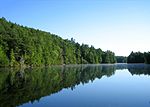
The Pequot Trail is a 7.6-mile (12.2 km) Blue-Blazed Trail, a hiking trail maintained by the Connecticut Forest and Park Association. The Pequot Trail extends...
8 KB (1,270 words) - 05:21, 7 November 2022

and infrastructure was beginning to appear as well as an economy. The Pequot Trail was used as a main highway to get around the Mystic River and played...
26 KB (2,727 words) - 17:00, 12 May 2024

map of major trails. Sections of the trail are on Mashantucket Pequot Tribal Nation property have been used for centuries by the Pequot tribe. Plans are...
21 KB (2,419 words) - 11:51, 24 June 2024

(ed.). Boston's Freedom Trail, Trace the Path of American History (Guidebook). Jack Frost (8th ed.). Guilford, CT: Globe Pequot. ISBN 978-0762747696. Retrieved...
8 KB (663 words) - 18:14, 30 April 2024
of Williams's Providence purchase. They settled at the ford where the Pequot Trail crossed the river, close to where the Warwick Avenue (US Hwy 1A/Hwy 117)...
40 KB (5,252 words) - 06:15, 25 June 2024

million restoration. It now includes a visitors' center and museum, hiking trails, and a picnic area. William Gillette's "castle", called Seventh Sister and...
14 KB (1,346 words) - 03:03, 4 June 2024

The Chisholm Trail (/ˈt͡ʃɪzəm/ CHIZ-əm) was a trail used in the post-Civil War era to drive cattle overland from ranches originated south of San Antonio...
16 KB (1,840 words) - 16:26, 27 May 2024

Westwoods Trails is an extensive hiking trail system in Guilford, Connecticut. The trail system has approximately 39 miles (63 km) of trails with features...
5 KB (663 words) - 17:00, 28 April 2024

The Ives Trail and Greenway is a 20-mile (32 km) hiking trail in the Housatonic Valley Region (also known as Greater Danbury). Its route connects Ridgefield...
4 KB (614 words) - 20:18, 20 May 2023

laid out the Arnold Road (modern-day Broad Street) connecting it to the Pequot Trail leading to Connecticut. Arnold's son Benedict Arnold became the first...
36 KB (3,217 words) - 16:42, 31 May 2024

Paugussett Trail Pequot Trail Quinnipiac Trail Regicides Trail Salmon River Trail Shenipsit Trail Tunxis Trail Westwoods Trails Whitestone Cliffs Trail Zoar...
7 KB (541 words) - 22:18, 1 August 2023

Sleeping Giant (Connecticut) (redirect from Sleeping Giant State Park Trails)
over 30 miles (48 km) of hiking trails traverse it including 5 miles (8 km) of the 23-mile (37 km) Quinnipiac Trail. Quinnipiac University is located...
22 KB (2,246 words) - 04:24, 8 November 2023

East Coast Greenway (category Rail trails in New York (state))
to Gardiner Rotary Centennial Trail – Benton Lewiston Riverside Trail – Lewiston Lisbon Trail – Lisbon Topsham Trail – Topsham Androscoggin River Bicycle...
45 KB (3,767 words) - 00:00, 26 April 2024

The Metacomet Trail is a 62.7-mile (100.9 km) Blue-Blazed hiking trail that traverses the Metacomet Ridge of central Connecticut and is a part of the newly...
28 KB (3,457 words) - 15:29, 22 August 2023

1 in the Pawcatuck section of Stonington. Route 234 is known as the Pequot Trail for its entire length. The section of Route 234 from the western terminus...
3 KB (266 words) - 02:35, 2 March 2023

The Menunkatuck Trail is an 11.0-mile (17.7 km) Blue-Blazed hiking trail in Guilford, Connecticut and, currently, is almost entirely on protected land...
10 KB (975 words) - 19:30, 29 June 2024
368 acre open space in Ridgefield, Connecticut. The space has many trails, trail heads and also one of Ridgefield's highest points, at 1,021 feet (311 m)...
3 KB (375 words) - 21:13, 18 June 2024

Lost Palms Oasis Trail is a 7.2-mile (11.6 km) day-hike trail located in the southernmost part of Joshua Tree National Park. The trail is generally completed...
4 KB (617 words) - 16:32, 9 May 2024

allow. Events and activities The park offers educational films, guided trail walks, and lectures. Warm-month activities include footprint track casting...
10 KB (778 words) - 02:37, 13 May 2024

stone formation. The Vista Point cliff, located at the end of the Orange Trail, stands 150 to 175 feet (53 m) above the Eightmile River. Other attractions...
7 KB (597 words) - 19:58, 29 June 2024

Trail Nipmuck Old Furnace Pachaug Paugussett Peoples Pequot Pine Knob Pomperaug Quinebaug Quinnipiac Ragged Mountain Regicides Risley Pond Loop Trail...
15 KB (1,994 words) - 15:25, 18 May 2024

The Quinebaug Trail is a 8.1-mile (13.0 km) Connecticut hiking trail and is one of the Blue-Blazed hiking trails maintained by the Connecticut Forest and...
16 KB (2,011 words) - 02:54, 29 December 2022

Forest Trails is a system of blue-blazed hiking trails in the Pleasant Valley section of Barkhamsted, Connecticut, United States. The trails, which collectively...
7 KB (779 words) - 01:18, 30 August 2023

Paugussett Trail Pequot Trail Quinnipiac Trail Regicides Trail Salmon River Trail Shenipsit Trail Tunxis Trail Westwoods Trails Whitestone Cliffs Trail Zoar...
6 KB (370 words) - 10:29, 26 April 2024
The Quinnipiac Trail is a 24-mile (39 km) Blue-Blazed hiking trail in New Haven County, Connecticut. It is the product of the evolution and growth of...
8 KB (1,215 words) - 19:58, 11 January 2021

Paugussett Trail Pequot Trail Quinnipiac Trail Regicides Trail Salmon River Trail Shenipsit Trail Tunxis Trail Westwoods Trails Whitestone Cliffs Trail Zoar...
12 KB (549 words) - 02:31, 17 May 2024
Bigelow Hollow State Park (redirect from Bigelow Hollow Trail)
at lower elevations and trails can be lost in the thick forest density. The park and forest have over 35 miles (56 km) of trails, including several around...
7 KB (545 words) - 05:55, 1 August 2023
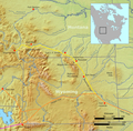
Bozeman Trail was an overland route in the Western United States, connecting the gold rush territory of southern Montana to the Oregon Trail in eastern...
21 KB (2,667 words) - 08:17, 17 May 2024
Scouting in Connecticut (redirect from Pequot Council)
1929. The Council ceased operations when it merged with Pequot Council to create the Indian Trails Council in 1971. Uncas Lodge #297 was the OA lodge for...
72 KB (10,811 words) - 04:00, 15 June 2024

encounters three sets of rapids. Hiking trails in neighboring Nepaug State Forest, including the Tunxis Trail, are accessible from Satan's Kingdom Road...
5 KB (289 words) - 15:44, 18 January 2024