
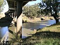
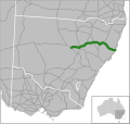
(The) Putty Road is a 168-kilometre (104 mi)-long rural road that links the Hunter Region in New South Wales to Wilberforce, just north of Windsor on the...
12 KB (860 words) - 06:50, 13 August 2024
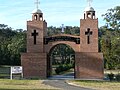
Putty is a village in New South Wales, Australia in Singleton Shire. It is north west of Sydney on the Putty Road between Windsor and Singleton. The village...
6 KB (777 words) - 02:41, 1 July 2024

Golden Highway (category Pages using infobox Australian road with a mapframe parameter)
near Singleton. The highway then turns east onto Mitchells Line of Road while Putty Road continues to Singleton. Golden Highway provides a fairly low altitude...
13 KB (989 words) - 06:33, 13 August 2024

A9 (Sydney) (redirect from The Northern Road)
to Wollongong via Sydney's western suburbs, along Putty Road, the current A9 route, and Appin Road. It was replaced by Metroad 9 between Windsor and Campbelltown...
22 KB (1,634 words) - 06:22, 13 August 2024
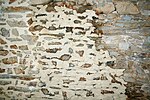
Lime mortar (redirect from Lime putty)
mature into a lime putty. A matured lime putty is thixotropic, meaning that when a lime putty is agitated it changes from a putty into a more liquid state...
30 KB (4,286 words) - 06:06, 28 September 2024

State Conservation Area, and the Putty Road; to the south by the Blue Mountains National Park and the Bells Line of Road; to the south–west by the Wolgan...
16 KB (1,255 words) - 04:59, 22 August 2024

1994. The town is located at the junction of the New England Highway and Putty Road. The Golden Highway branches northwest from the New England Highway ten...
26 KB (2,538 words) - 05:38, 10 August 2024

at Putty Road, Wallaby Swamp Trail and Staircase Spur Trail at Colo Heights On 19 November, at Putty Road, Barina Road and Wheelbarrow Ridge Road at Colo...
322 KB (29,828 words) - 20:51, 25 September 2024

its 86-kilometre (53 mi) course. At Colo, the river is crossed by the Putty Road (B84). Parts of the area surrounding the river, including both the Blue...
8 KB (554 words) - 09:21, 26 April 2024

Hume Highway (redirect from Great South Road (New South Wales))
at Parramatta Road, in Ashfield. This route is numbered as A22. The first 31 kilometres (19 mi) of the highway was known as Liverpool Road until August...
94 KB (10,496 words) - 03:34, 28 September 2024
northwest of the locality of Putty. The river flows generally south southeast and south southwest, generally adjacent to the Putty Road, joined by seven minor...
5 KB (333 words) - 14:57, 25 January 2024

Princes Motorway (redirect from Mount Ousley Road)
Mount Ousley Road, and was first built as a defence route and later upgraded to dual carriageway standards. It is the backbone of road traffic in the...
33 KB (2,766 words) - 00:31, 9 September 2024

Bells Line of Road is a 59-kilometre (37 mi) major road located in New South Wales, Australia, providing an alternative crossing of the Blue Mountains...
17 KB (1,566 words) - 06:32, 13 August 2024

Broke; in the north by Wollombi Brook; in the west by the Putty Road, the settlements of Putty and Mellong, and the Mellong Range; and in the south by the...
8 KB (732 words) - 22:20, 11 January 2024
original site. This cemetery sits on Old Sackville Road, near the intersection with Singleton Road (Putty Road). There are a number of graves of the area's...
8 KB (810 words) - 04:53, 28 June 2024
other scenes are set in the district and along the southern end of the Putty Road to Singleton. It was centred on the lives of a group of volunteer firefighters...
20 KB (692 words) - 04:02, 31 May 2024

known as the (Lower) Hunter Valley proper in 1820. Today, the modern Putty Road between the cities of Windsor and Singleton follows Howe's exact path...
47 KB (3,788 words) - 06:48, 13 July 2024

Kings Highway (Australia) (category WikiProject Australian Roads articles with a junction list using templates)
State government through the Main Roads Board (later Transport for NSW). Main Road No. 51 was declared along this road on 8 August 1928, from the intersection...
19 KB (1,680 words) - 05:47, 12 September 2024
Newell Highway (category WikiProject Australian Roads articles with a junction list using templates)
national highway in New South Wales (NSW), Australia. It provides the major road link between southeastern Queensland and Victoria via central NSW and as...
30 KB (2,352 words) - 06:07, 6 October 2024

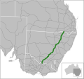
Mangrove Creek joins the river from the north. From here to the river mouth, road access to the river is limited to a few points. At Milsons Passage, the river...
29 KB (2,454 words) - 05:31, 18 September 2024

Princes Highway (redirect from Dandenong Road)
Princes Highway is a major road in Australia, extending from Sydney via Melbourne to Adelaide through the states of New South Wales, Victoria and South...
84 KB (5,307 words) - 05:36, 13 August 2024

Great Western Highway (redirect from Great Western Road (New South Wales))
also has local road names between the Sydney city centre and Parramatta, being: Broadway from Haymarket to Chippendale, Parramatta Road from Chippendale...
57 KB (5,784 words) - 06:20, 13 August 2024

New England Highway (category WikiProject Australian Roads articles with a junction list using templates)
strategic roads. The sections are: 22A – Yarraman to Toowoomba 22B – Toowoomba to Warwick 22C – Warwick to Wallangarra State-controlled roads that intersect...
41 KB (2,871 words) - 00:51, 9 September 2024
Road routes in New South Wales assist drivers navigating roads in urban, rural, and scenic areas of the state. Today all numbered routes in the state are...
77 KB (1,271 words) - 22:25, 6 September 2024

Australiana Pioneer Village (section "Salter" Barn (formerly part of 498 Wilberforce Road, Wilberforce))
Originally sited in Wilberforce on the SW corner of the Singleton (Putty) Road and King Street, only a couple of hundred metres from its present relocation...
75 KB (11,048 words) - 05:54, 25 May 2024
Castlereagh Highway (redirect from A55 road (Queensland))
October 1997, subsuming Main Road 77 (previously Trunk Road 77). The southern end of Main Road 56 (previously Trunk Road 56) was truncated to meet State...
21 KB (1,602 words) - 06:36, 13 August 2024
Ferry". New South Wales Roads and Traffic Authority. Archived from the original on 25 August 2006. Retrieved 18 November 2008. Roads and Maritime Services...
3 KB (255 words) - 21:05, 12 May 2024
1997 Istabraq Mighty Moss Daraydan 1996 Urubande Go-Informal Karshi 1995 Putty Road Berude Not To Treble Bob 1994 Danoli Corrouge Brief Gale 1993 Gaelstrom...
26 KB (384 words) - 18:18, 17 April 2024
Oxley Highway (category WikiProject Australian Roads articles with a junction list using templates)
Bendemeer existed as a mapped road in 1857, was surveyed in 1867, and proclaimed a Parish Road in c.1889. West of Walcha the road was only suitable for bullock...
16 KB (1,281 words) - 06:02, 13 August 2024

Pacific Motorway (Brisbane–Brunswick Heads) (category WikiProject Australian Roads articles with a junction list using templates)
April 1979. 1980 – Marshall Road to Klumpp Road. Third stage of the South-East Freeway between Marshall Road and Klumpp Road officially opened on 21 October...
53 KB (3,321 words) - 20:18, 25 September 2024