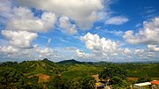
Quebrada Grande is a barrio in the municipality of Barranquitas, Puerto Rico. Its population in 2010 was 3,217. Quebrada Grande was in Spain's gazetteers...
9 KB (615 words) - 06:29, 1 January 2024

region of Puerto Rico, south of Corozal and Naranjito; north of Coamo and Aibonito; west of Comerío and Cidra; and east of Orocovis. Barranquitas is spread...
36 KB (2,483 words) - 19:55, 27 September 2024

Orocovis, Corozal, Barranquitas, Coamo, Comerío and Aibonito; this section contains the highest peaks of the range and Puerto Rico, such as Cerro de Punta...
49 KB (3,371 words) - 22:35, 18 October 2024
Cayey, Puerto Rico, a barrio Quebrada Arriba, Patillas, Puerto Rico, a barrio Quebrada Grande, Barranquitas, Puerto Rico, a barrio Quebrada Grande, Mayagüez...
2 KB (320 words) - 11:03, 2 January 2024

) is a town and municipality of Puerto Rico located in the central-eastern region, north of Orocovis and Barranquitas; south of Vega Alta; southwest of...
38 KB (2,773 words) - 20:32, 27 September 2024

List of rivers in Puerto Rico (U.S. Commonwealth), sorted by drainage basin and then alphabetically. There are 47 main rivers and 24 lagoons or reservoirs...
17 KB (1,448 words) - 18:39, 30 January 2024

highway system in Puerto Rico is composed of approximately 14,400 kilometers (8,900 mi) of roads in Puerto Rico, maintained by the Puerto Rico Department of...
171 KB (3,645 words) - 00:23, 18 September 2024

Puerto Rico Highway 152 (PR-152) is a rural road that travels from Barranquitas to Naranjito in Puerto Rico. This road extends from PR-156 in downtown...
9 KB (412 words) - 01:48, 6 February 2024
Quebrada Fajardo, Fajardo Quebrada Grande, Barranquitas Quebrada Grande, Mayagüez Quebrada Grande, Trujillo Alto Quebrada Honda, Guayanilla Quebrada Honda...
76 KB (3,116 words) - 10:42, 8 April 2024

Comerío and Barranquitas. This route extends from its junction with PR-1 in downtown Caguas to PR-5155 in downtown Orocovis. Comerío to Barranquitas Road (currently...
16 KB (538 words) - 01:50, 6 February 2024

This portion of National Register of Historic Places listings in Puerto Rico is along the central mountain region, from Las Marías and Maricao in the...
47 KB (810 words) - 21:25, 6 September 2024
Ruta Panorámica (redirect from Puerto Rico Highway 7718)
of Coamo (Eastbound) PR-143 Municipality of Barranquitas (Eastbound) PR-723 Municipality of Barranquitas (Southbound) PR-7718 Municipality of Aibonito...
25 KB (897 words) - 06:05, 22 November 2023
Primero Quebrada Limón Quinto Real Sabanetas San Antón San Patricio Segundo Sexto Tercero Tibes Vayas Bayamón City Hall Birds of Puerto Rico Black history...
33 KB (3,464 words) - 15:22, 15 October 2024
Las Bocas Canyon (category Barranquitas, Puerto Rico)
boundary between the municipalities of Barranquitas and Comerío in the central region of the main island of Puerto Rico. Situated between the eponymous main...
5 KB (468 words) - 07:33, 8 September 2024

Ball court/plaza sites of Puerto Rico and the U.S. Virgin Islands are the subject of a multiple property submission to the National Register of Historic...
10 KB (359 words) - 17:32, 23 September 2023

the following rivers: Quebrada Grande (Salto Grande) in Corozal Quebrada Riachuelo in Corozal Río Botijas in Orocovis Río Grande de Manatí in Corozal The...
13 KB (816 words) - 01:50, 6 February 2024

Puerto Rico Highway 155 (PR-155) is a rural road that goes from Coamo, Puerto Rico to Vega Baja through Orocovis and Morovis. It extends from PR-14 in...
12 KB (305 words) - 01:27, 6 February 2024