East and then west to the vicinity of Toronto City Hall. The proposal included intermediate stations at Sherbourne Street, Sumach Street, Broadview Avenue...
132 KB (12,851 words) - 01:28, 28 June 2024
became Sherbourne Health Centre in 2003. The Doctor's Hospital (1953–1997) – merged with Toronto Western Hospital in 1996, merged again with Toronto General...
11 KB (323 words) - 15:35, 13 February 2024

The Toronto Islands are a chain of 15 small islands in Lake Ontario, south of mainland Toronto, Ontario, Canada. Comprising the only group of islands in...
75 KB (7,524 words) - 17:39, 27 May 2024

of the oldest buildings and structures in Toronto, that were constructed before 1920. The history of Toronto dates back to Indigenous settlements in the...
197 KB (3,535 words) - 12:44, 21 April 2024
the eastern outskirts of downtown Toronto. The road ends at Bloor Street East between the Rosedale and Sherbourne phases of the Prince Edward Viaduct...
108 KB (10,381 words) - 01:17, 28 June 2024

Toronto Harbour or Toronto Bay is a natural bay on the north shore of Lake Ontario, in Toronto, Ontario, Canada. Today, the harbour is used primarily for...
37 KB (3,509 words) - 22:55, 8 January 2024
Wellesley district, the city's primary gay village. Further east past Sherbourne Street, the street marks the boundary between the St. James Town and Cabbagetown...
73 KB (7,665 words) - 00:48, 18 June 2024
Toronto, Ontario, Canada. The appearance of Toronto's ravines was altered by floods caused by Hurricane Hazel in October 1954 and many of Toronto's parks...
28 KB (2,458 words) - 01:27, 19 June 2024

2009 – Waterfront Toronto breaks ground on the new Sherbourne Park. 2009 – Toronto City Centre Airport renamed Billy Bishop Toronto City Airport. 2010...
36 KB (4,699 words) - 17:07, 10 May 2024

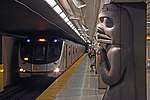
Line 2 Bloor–Danforth (redirect from Green Line (Toronto))
Line 2 Bloor–Danforth is a subway line in the Toronto subway system, operated by the Toronto Transit Commission (TTC). It has 31 stations and is 26.2 kilometres...
100 KB (9,796 words) - 00:45, 23 June 2024

The Toronto ravine system is a distinctive feature of the city's geography, consisting of a network of deep ravines, which forms a large urban forest...
46 KB (5,319 words) - 21:12, 15 January 2024

Scarborough Bluffs (category Landforms of Toronto)
also known as The Bluffs, is an escarpment in the Scarborough district of Toronto, Ontario, Canada. There are nine parks along the bluffs, with Bluffers...
13 KB (1,633 words) - 22:07, 19 June 2024

Rob Ford (category Businesspeople from Toronto)
separated bike lanes on Sherbourne Street were installed. Toronto Cyclist Union president Andrea Garcia praised the Sherbourne lanes installation: "Cities...
70 KB (7,297 words) - 00:38, 26 May 2024

Ontario Line (category Proposed Toronto rapid transit projects)
station added near the Exhibition GO Station. The section between Queen/Sherbourne and Gerrard stations would come to the surface and mostly follow a railway...
92 KB (8,465 words) - 18:00, 28 June 2024
The Boys (TV series) (category Television shows filmed in Toronto)
Roy Thomson Hall, the Yonge–Dundas Square, Lower Bay Station, and the Sherbourne Common. In order to make it look like New York City and create the fictional...
172 KB (12,946 words) - 17:00, 28 June 2024

completed an assessment report in 2015 but the project has not proceeded. Sherbourne Conference Centre Monorail, Saint Michael, Barbados was proposed in 2008...
86 KB (6,438 words) - 03:02, 8 June 2024

Beach Metro Community News. 2017-05-16. Retrieved 2018-11-06. Cruikshank, Tom (2003). Old Toronto Houses. photographs by John de Visser. Toronto: Firefly...
5 KB (553 words) - 11:55, 26 May 2023
Queen Elizabeth Way (category Toronto highways)
(QEW) is a 400-series highway in the Canadian province of Ontario linking Toronto with the Niagara Peninsula and Buffalo, New York. The highway begins at...
95 KB (9,270 words) - 22:14, 19 June 2024
locations from the city of Toronto such as the Roy Thomson Hall, the Yonge–Dundas Square, Lower Bay Station, and the Sherbourne Common. In order to make...
97 KB (7,724 words) - 13:38, 25 June 2024

configuration. The Council opted for a new bicycle route along the parallel Sherbourne Street. On November 17, 2012, following removal of the bicycle lanes,...
20 KB (2,225 words) - 10:14, 19 April 2024

Leslie Street Spit (category Landforms of Toronto)
officially the Outer Harbour East Headland, is a human-made headland in Toronto, Ontario, Canada, extending from the city's east end in a roughly southwesterly...
18 KB (2,117 words) - 02:16, 8 June 2024

Confederation Line (redirect from Sherbourne station (Ottawa))
The Confederation Line (French: Ligne de la Confédération), also called O-Train Line 1 (French: Ligne 1 de l'O-Train), is a light rail line operated by...
50 KB (4,236 words) - 22:46, 15 June 2024

Rouge National Urban Park (category Beaches of Toronto)
tributaries in the Greater Toronto Area. The southern portion of the park is situated around the mouth of the river in Toronto, and extends northwards into...
33 KB (4,172 words) - 17:47, 19 June 2024

St. David (provincial electoral district) (category Provincial electoral districts of Toronto)
from 1926 to 1987. It covered a section of the eastern city of Toronto east of Sherbourne Street and west of the Don River. The riding lasted until 1987...
27 KB (1,286 words) - 00:04, 12 May 2022
McCormick Park (category Parks in Toronto)
Avenue in the Brockton Village neighbourhood enclave of Little Portugal in Toronto, Ontario, Canada. Opened in 1911 as the McCormick Playground on the property...
60 KB (5,551 words) - 18:01, 9 December 2023

Beltline Trail (category Transport in Toronto)
Trail is a 9-kilometre (5.6 mi)-long cycling and walking rail trail in Toronto, Ontario, Canada. It consists of three sections, the York Beltline Trail...
9 KB (1,030 words) - 03:19, 27 October 2023
that were demolished or lost due to fire or other causes in what is now Toronto, Ontario, Canada. In some cases, facades or portions of the original buildings...
29 KB (413 words) - 03:31, 6 February 2024
alongside marchers from the Sherbourne Health Center, a community clinic focused on the health needs of new immigrants to Toronto, the lesbian, gay, bisexual...
45 KB (4,226 words) - 14:02, 24 April 2024
List of Moose in the City (category Public art in Toronto)
The following were moose in the Moose in the City program in Toronto, Ontario in 2000. Majestic Moose Blue Moose Moose Transit Commission Coffee "Mousse"...
69 KB (223 words) - 02:55, 23 February 2024
public transport purposes, and is more like an urban railway rather than a metro or tramway. It is often described as "light rail", partly because there...
42 KB (4,356 words) - 01:53, 8 May 2024