
Sligachan (Scottish Gaelic: Sligeachan) is a small settlement on Skye, Scotland. It is close to the Cuillin mountains and provides a good viewpoint for...
4 KB (321 words) - 09:20, 7 June 2024

from the Red Cuillin (na Beanntan Dearga), which lie to the east of Glen Sligachan. The peaks of the Black Cuillin are mainly composed of gabbro, a very...
34 KB (3,585 words) - 09:44, 3 August 2024

Ainort and the settlement of Sligachan. Beinn Dearg Mhor is the middle summit of the three big Red Hills near Sligachan, along with Marsco and Glamaig...
2 KB (112 words) - 09:27, 11 April 2022

Red Hills on the Isle of Skye in Scotland. It lies immediately east of Sligachan. It is one of only two Corbetts on Skye. From many angles the hill resembles...
4 KB (384 words) - 08:00, 30 July 2024

retired in 1929 and thereafter spent his summers in Skye. He died at Sligachan in November 1942 from pneumonia, after falling into Loch Leathan below...
15 KB (1,602 words) - 15:56, 1 August 2024
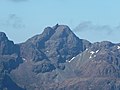
Munros in the Cuillins. It is the Munro peak nearest to the settlement of Sligachan, and its impressive triangular profile makes it one of the most recognizable...
5 KB (570 words) - 16:51, 21 July 2024
Skye in 1395, but Iain's grandson William MacLeod met the MacDonalds at Sligachan (Sligichen) and drove them back to Loch Eynort (Ainort). There they found...
35 KB (3,445 words) - 09:13, 17 August 2024

the Duirinish Peninsula), to Loch Harport in the north east, and Glen Sligachan in the south east. It includes most of the peaks of the Cuillin hills...
4 KB (421 words) - 17:52, 23 May 2023

Scotland. It lies on the east of Glen Sligachan, and may be climbed from the right-of-way through the glen from Sligachan to Loch Coruisk. Alternatively, it...
2 KB (155 words) - 05:48, 18 December 2023

Eurasian oystercatcher flying on Loch Sligachan on the Isle of Skye, Scotland...
13 KB (1,415 words) - 01:20, 31 August 2024

Craigellachie Bridge 1815 Dunans Bridge 1815 Waterloo Bridge, Betws-y-Coed 1818 Sligachan Old Bridge 1819 Bannockburn Bridge 1820 Cantlop Bridge 1823 Stanley Embankment...
34 KB (3,646 words) - 04:09, 19 August 2024

Torridonian sandstone quarry near Sconser. Hornfelsed lava has been worked near Sligachan and dolerite quarried from a sill near Invertote for a similar purpose...
10 KB (1,170 words) - 18:35, 12 June 2024

professional mountain guide. As a teenager MacKenzie worked as a pony man for Sligachan Hotel helping tourists to visit Loch Coruisk. It is believed that he first...
9 KB (967 words) - 22:43, 7 September 2023
and Lawrence Pilkington. They were guided to the foot of the climb from Sligachan via Coruisk and Bealach Coire na Banachdich by a local shepherd called...
8 KB (915 words) - 19:03, 30 June 2024

human form. The loch is accessible by boat from Elgol, or on foot from Sligachan (approximately 7–8 miles or 11–13 kilometres distance). It is also possible...
4 KB (439 words) - 22:11, 13 November 2023
TPRC Data Series on page 1072. Fiberglass or foam-glass 0.045 293 Gabbro Sligachan Gabbro 2.55 2.47 List Generic Gabbro* 2.06 ± 0.2 List: Birch and Clark...
139 KB (4,006 words) - 08:04, 3 July 2024

Painting of Glen Sligachan, Skye, by Keeley Halswelle...
5 KB (571 words) - 20:14, 13 May 2024

the opposite shore of Loch Beag. The parish reaches eastwards as far as Sligachan. The name could derive from the Old Norse for "juniper dale" or "bracken...
3 KB (223 words) - 12:14, 21 June 2024

Rèinigeadal (Harris) Roag (Skye) Rodel (Harris) Sconser (Skye) Skeabost (Skye) Sligachan (Skye) Staffin (Skye) Stoneybridge (South Uist) Stein (Skye) Sollas (North...
48 KB (4,653 words) - 05:43, 3 September 2024

A850 road Portree – second junction with the A855 road Glenvarragill Sligachan – junction with the A863 road Sconser Luib Dunan Broadford Harrapool junction...
5 KB (403 words) - 04:31, 21 January 2024
Siginish (North Uist) Loch Skipport (South Uist) Loch Slapin (Skye) Loch Sligachan (Skye) Loch Snizort (Skye) Loch Snizort Beag (Skye) Loch Spelve (Isle...
9 KB (1,004 words) - 09:21, 25 May 2024

'burn' or 'allt', bear the name 'river' in Skye. Broadford River River Sligachan Allt Dearg Mòr Varragill River River Leasgeary River Chracaig Lealt River...
42 KB (4,541 words) - 17:26, 30 June 2024

Pinnacle in the same range. The easiest route to the summit starts from Sligachan following a path along the left bank of the Allt Dearg Beag (small red...
3 KB (293 words) - 13:59, 18 December 2023

Early Spring (1855), Ashmolean Museum, Oxford. Cuillin Ridge, Skye, from Sligachan (1856), Ashmolean Museum, Oxford. Study from Nature, Evening (1857) Fishermen...
7 KB (877 words) - 09:29, 18 April 2024

the island of Skye, in Scotland, situated on the south shore of Loch Sligachan. The main A87 road of Skye passes through Sconser and the ferry to Raasay...
2 KB (150 words) - 21:30, 4 August 2024

for mountaineering. The Bruach cannot be seen in the popular view from Sligachan - the right hand peak which is often mistaken for it is the lower Sgurr...
3 KB (182 words) - 08:23, 29 October 2023
Upload Photo Sligachan, Old Bridge (Over River Sligachan) 57°17′23″N 6°10′24″W / 57.289802°N 6.173365°W / 57.289802; -6.173365 (Sligachan, Old Bridge...
2 KB (277 words) - 14:11, 16 February 2024

North Roe Rùm Sanday, Orkney Sands of Forvie Shelforkie Shingle Islands Sligachan Peatlands Slochd Solway Firth Solway Mosses North Sound of Arisaig (Loch...
6 KB (653 words) - 13:16, 13 March 2024

the A850 road Lonmore Roskhill Ose Struan Bracadale Coillore Drynoch Sligachan– junction with the A87 Ordnance Survey. "View: Sheet 24, North Skye –...
2 KB (182 words) - 06:15, 21 January 2024

Skerray, Skinnet, Skinidin, Skirza, Skulamus Skullomie, Skye of Curr, Sligachan, Sluggans, Smerral, Smithton, Sordale South Ballachulish, South Duntulm...
19 KB (1,757 words) - 15:32, 23 January 2024