
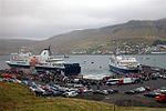
Streymoy (Faroese pronunciation: [ˈstɾeɪ̯mɔɪ̯], Danish: Strømø) is the largest and most populated island of the Faroe Islands. The capital, Tórshavn, is...
9 KB (816 words) - 10:42, 1 September 2023

Týr (band) (redirect from Kári Streymoy)
bandmate, Kári Streymoy, at a party in January in Copenhagen. Joensen suggested to Streymoy that they should meet up and jam. Streymoy initially declined...
20 KB (1,914 words) - 15:50, 15 April 2024
tunnel connecting Eysturoy and Streymoy, which was completed in 2020, and Sandoyartunnilin, a tunnel connecting Streymoy and Sandoy, will be completed...
15 KB (1,558 words) - 08:56, 22 May 2024

Syðradalur (redirect from Syðradalur, Streymoy)
Syðradalur (Faroese pronunciation: [ˈsiːɹaˌdɛalʊɹ], is a village on the island of Kalsoy, one of the Faroe Islands. Syðradalur is the southernmost village...
6 KB (249 words) - 09:11, 23 January 2024

Kirkebø) is the southernmost village on Streymoy, Faroe Islands. The village is located on the south-west coast of Streymoy and has a view towards the islands...
10 KB (616 words) - 15:14, 15 September 2023

Kaldbaksbotnur is a village on the island of Streymoy in the Faroe Islands. Kaldbaksbotnur is located on the east coast of Streymoy. The village consists two farms...
7 KB (379 words) - 15:16, 15 September 2023

small village in the Faroe Islands. It is located on the west coast of Streymoy, in Tórshavn Municipality. Not to be confused with Syðradalur village on...
4 KB (66 words) - 15:12, 15 September 2023

undersea road tunnel in the Faroe Islands. It connects the main island of Streymoy with Sandoy to the south. The length of the tunnel is 10.8 kilometres (6...
7 KB (646 words) - 16:46, 24 September 2024

islands of Streymoy and Vágar. The tunnel was the first sub-sea tunnel in the Faroe Islands, and connects the capital of Tórshavn on Streymoy with Vágar...
4 KB (336 words) - 16:32, 29 September 2024

[ˈkɔl̥tʊɹ]) is an island in the Faroe Islands, located to the west of Streymoy and to the north-west of Hestur. The name 'Koltur' means 'colt', in contrast...
9 KB (934 words) - 10:43, 7 September 2024
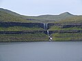
Fossá (category Streymoy)
waterfalls in the Faroe Islands, and one of the biggest attractions in northern Streymoy. "Fossá" in the Faroese language means "river with waterfalls", and there...
2 KB (168 words) - 20:24, 25 February 2024

(Danish: Hestø) is an island in the central Faroe Islands, to the west of Streymoy and the south of Koltur. Hestur means horse in Faroese. On the west coast...
5 KB (332 words) - 15:52, 10 May 2023

Sunda, Faroe Islands (category Streymoy)
Islands, loosely centered around the Sundini sound between the islands of Streymoy and Eysturoy. Sunda is an amalgamation of the former municipalities of...
7 KB (412 words) - 14:54, 27 February 2024

year. In 1769, they were observed in Tórshavn on the southern part of Streymoy, and a decade later, in the villages in the northern part of this island...
67 KB (8,005 words) - 18:11, 3 October 2024
were seven electoral districts, each one comprehending asýslur, while Streymoy is divided into northern and southern parts (Tórshavn region), but since...
11 KB (750 words) - 23:10, 26 June 2024

Faroe Islands. It is located in the southern part on the east coast of Streymoy. To the northwest of the city lies the 347-meter-high (1,138 ft) mountain...
33 KB (2,764 words) - 20:04, 5 September 2024

Faroe Islands, located in a valley on the east coast of the island of Streymoy. It is the southern half of a twin-village situated on both sides of the...
4 KB (294 words) - 07:53, 21 April 2023

62.000; -6.783 Archipelago Faroe Islands Total islands 18 Major islands Streymoy, Eysturoy, Vágar, Suðuroy Area 1,399 km2 (540 sq mi) Highest elevation...
4 KB (72 words) - 03:01, 2 September 2022

Leynartunnilin 1977 760 2,490 Leynar and the valley of Kollafjarðardalur Streymoy Replaced an avalanche prone road. Villingardalstunnilin 1979 1,193 3,914...
20 KB (531 words) - 00:51, 7 September 2024

Saksun is a village near the northwest coast of the Faroese island of Streymoy, in Sunda Municipality. Saksun lies in the bottom of what used to be an...
5 KB (182 words) - 15:37, 9 August 2024

Koltur, Kunoy, Lítla Dímun, Mykines, Nólsoy, Sandoy, Skúvoy, Stóra Dímun, Streymoy, Suðuroy, Svínoy, Vágar, Viðoy Greenland (Denmark) Appat Island, Akilia...
8 KB (731 words) - 03:22, 5 August 2024

61.45556°N 6.75917°W / 61.45556; -6.75917 Argir 1907 FO 160 Tórshavnar Streymoy 61°59′53″N 6°46′23″W / 61.99806°N 6.77306°W / 61.99806; -6.77306 Ánir...
21 KB (57 words) - 23:01, 8 July 2024

landscape shape. This can be clearly seen on Vágar, the northernmost part of Streymoy and the north-western part of Eysturoy. Glacial activity has reduced plateau...
151 KB (16,026 words) - 13:51, 3 October 2024

Magnuskatedralen) is a ruined cathedral in the village of Kirkjubøur on the island of Streymoy in the Faroe Islands. The ruins are the largest medieval building in the...
5 KB (542 words) - 13:50, 1 October 2024

the Tangafjørður sound in the Faroe Islands, connecting the island of Streymoy to the island of Eysturoy, meaning east island. It also crosses the southern...
23 KB (2,351 words) - 15:47, 24 September 2024

Sornfelli is a mountain plateau on the island of Streymoy in the Faroe Islands about 12 km from the capital Tórshavn (20 km by road). It is the site of...
2 KB (189 words) - 09:16, 30 July 2023

Kaldbak (Danish: Kalbak) is a village in the Faroe Islands, on Streymoy's east coast and part of Tórshavn Municipality. The village lies on the northern...
5 KB (116 words) - 15:16, 15 September 2023

Haldersvig), also Haldarsvík, is a village located on the north-east coast of Streymoy in the Sunda Kommuna municipality. In the centre of the village there is...
5 KB (141 words) - 15:13, 15 September 2023

Tjørnuvík (Danish: Tjørnevig) is the northernmost village on Streymoy in Sunda Municipality, Faroe Islands. As of the 2006 census, the population has a...
6 KB (176 words) - 09:33, 13 July 2023

region (SA), Sandoy, Skúvoy, Stóra Dímun. Streymoyar sýsla – Streymoy region (TN). Streymoy, Hestur, Koltur, Nólsoy. Suðuroyar sýsla – Suðuroy region. Lítla...
4 KB (482 words) - 01:56, 2 November 2023