
U.S. Route 19E (US 19E) is a divided highway of US 19 in the U.S. states of North Carolina and Tennessee. The United States Numbered Highway, which is...
13 KB (853 words) - 19:10, 17 May 2024

(July 2, 2014). "US 19 in North Carolina" (Map). Google Maps. Google. Retrieved July 2, 2014. Google (August 26, 2011). "U.S. Route 19E" (Map). Google Maps...
51 KB (5,053 words) - 21:17, 3 August 2024

the intersection of US 19/US 19E. Several signs at the beginning of the route strongly recommend truckers against using this route. The road then proceeds...
9 KB (532 words) - 22:52, 17 February 2024
community of Tiger Valley, and runs in a northerly direction alongside U.S. Route 19E until its termination into Doe River just south of the town of Hampton...
2 KB (127 words) - 22:28, 13 November 2020
U.S. Route 321 (US 321) is a spur of U.S. Route 21. It runs for 516.9 miles (831.9 km) from Hardeeville, South Carolina to Lenoir City, Tennessee; with...
62 KB (2,858 words) - 04:23, 15 June 2024
(Elizabethton); U.S. Route 321 east to Elizabethton, and; U.S. Route 19E at Elizabethton then south into Roan Mountain, Tennessee. US 19 splits into US 19E and US 19W...
14 KB (1,361 words) - 20:18, 20 March 2024

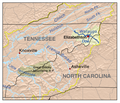
area to the east. Tennessee State Route 173 connects the town with U.S. Route 19E. According to the United States Census Bureau, the town has a total...
13 KB (1,025 words) - 20:32, 7 August 2024

U.S. Route 11E (US 11E) is a divided highway of US 11 in the U.S. states of Tennessee and Virginia. The United States Numbered Highway, which is complemented...
33 KB (2,321 words) - 00:23, 15 August 2024

paralleled by State Route 143; at the community of Roan Mountain, Tennessee, it then turns west and is at this point paralleled by U.S. Route 19E. The Doe River...
66 KB (7,200 words) - 04:11, 27 August 2024
the highway splits into US 19E and US 19W, which both head into North Carolina and rejoin to form US 19 in North Carolina. US 19's Tennessee portion ends...
6 KB (469 words) - 00:24, 15 August 2024

United States Numbered Highway System (redirect from U.S. Route)
generally spur routes of parent highways; for example, U.S. Route 264 (US 264) is a spur off US 64. Some divided routes, such as US 19E and US 19W, exist...
46 KB (5,110 words) - 01:50, 20 August 2024

2014, The North Carolina Department of Transportation began widening U.S. Route 19E, which is the major corridor linking the towns of Spruce Pine and Burnsville...
17 KB (1,391 words) - 16:37, 4 June 2024
Valley Forge community, and is rejoined by U.S. Route 19E outside of Elizabethton. Flowing parallel with U.S. Highway 19-E, the Doe River flows underneath...
14 KB (811 words) - 23:04, 23 August 2022
of Bellview, to Cane River, where US 19 splits into US 19E and US 19W, which take separate routes into Tennessee. US 19 enters North Carolina at the Georgia...
26 KB (1,914 words) - 14:48, 17 February 2024

Some U.S. Routes are given directional suffixes to indicate a split of the main route — for instance, U.S. Route 25 (US 25) splits into US 25E (east)...
28 KB (278 words) - 23:00, 14 June 2024

located where Brushy Creek crosses U.S. Route 19E (US 19E), west of Spruce Pine. The name Estatoe, pronounced 'S - ta - toe', comes from a story about...
4 KB (249 words) - 10:43, 16 March 2024

it does go through a mountainous area. Its northern terminus is U.S. Route 19E (US 19E) in the town of Roan Mountain and its southern terminus is North...
2 KB (176 words) - 07:34, 12 August 2023

intersection with US 19E/SR 37 (Highway 19E), where SR 91 splits off and goes north along US 19E/SR 37 while US 321/SR 67 turns south along US 19E/SR 37. Further...
13 KB (1,019 words) - 05:29, 29 January 2024
State Route 400 runs through the southern part of the community, leading south into Elizabethton and west 5 miles (8 km) to Watauga. U.S. Route 19E runs...
5 KB (211 words) - 19:38, 20 March 2024
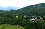
County, Tennessee that is located on Tennessee State Route 173 at its junction with U.S. Route 19E. Tiger Valley is located south of Elizabethton, the...
787 bytes (76 words) - 18:00, 19 November 2023

In the U.S. state of North Carolina U.S. Route 221 (US 221) is a north–south highway that travels through Western North Carolina. From Chesnee, South...
29 KB (2,031 words) - 14:48, 17 February 2024

North Carolina Highway 104 (redirect from North Carolina Route 104)
NC 104 was truncated to the current US 70-NC 80 junction. In 1930 the road was extended along US 19E then was routed to Loafers Glory. In 1940 NC 104 was...
3 KB (271 words) - 03:32, 5 February 2022

and continues southeast until it comes to an intersection with Old U.S. Route 19E. It then turns south and crosses over the Watauga River again and enters...
3 KB (220 words) - 01:03, 31 July 2023

North Carolina Highway 69 (redirect from North Carolina Route 69)
decommissioned in favor of US 25, US 19 and US 19E. Between 1930 and 1960, NC 69 was a usually part of a multi-state route 69 that travels through Georgia...
9 KB (750 words) - 13:57, 26 August 2024

North Carolina Highway 128 (redirect from North Carolina Route 128)
(84 km) byway from the I-26 exit 9 to the top of Mount Mitchell, via US 19, US 19E, NC 80, Blue Ridge Parkway and NC 128. This designation became official...
4 KB (447 words) - 03:38, 5 February 2022
Carter County, Tennessee. Located along US Route 19E/321 and SR-67, south of Elizabethton and north of Hampton. U.S. Geological Survey Geographic Names Information...
705 bytes (55 words) - 17:59, 19 November 2023

North Carolina Highway 80 (redirect from North Carolina Route 80)
connects with US 19E, where travelers can continue on towards Burnsville or Spruce Pine. After a 2.25-mile (3.62 km) overlap with US 19E, NC 80 continues...
10 KB (914 words) - 02:26, 2 February 2022

of US 19W and US 19E, northeast via Hickory Tree and Holston Valley to the Virginia state line, where it becomes Virginia State Route 75. The entire...
5 KB (438 words) - 08:49, 11 August 2023

east on Tennessee State Route 67 to Elizabethton, then left on Tennessee State Route 67 /US 19E then right on Tennessee State Route 91 Stoney Creek Exit...
9 KB (669 words) - 20:06, 20 March 2024
enter the community of Tiger Valley, where it comes to an end at US 19E. From here, US 19E continues eastward to Roan Mountain, and northwestward to Hampton...
4 KB (220 words) - 07:37, 12 August 2023