
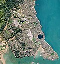
The Upper Waitematā Harbour is an estuary of the Waitematā Harbour in the Auckland Region of New Zealand. It flows south-east from the town of Riverhead...
15 KB (1,329 words) - 08:00, 25 April 2024

Waitematā Harbour is the main access by sea to Auckland, New Zealand. The harbour forms the northern and eastern coasts of the Auckland isthmus and is...
16 KB (1,720 words) - 03:30, 3 August 2024

Lucas Creek (category Waitematā Harbour catchment)
Shore, and enters the Upper Waitematā Harbour between Pāremoremo and Greenhithe. Lucas Creek is an arm of the Upper Waitematā Harbour. The creek begins as...
19 KB (1,682 words) - 23:29, 10 May 2024

Upper Waitematā Harbour, an estuarial arm of the Waitematā Harbour. The area includes the western suburbs of Whenuapai, Herald Island, West Harbour and...
2 KB (115 words) - 07:30, 21 July 2024

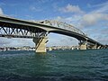
Auckland, New Zealand. It is technically two bridges, spanning the Upper Waitematā Harbour, and connecting Hobsonville (in West Auckland) and Greenhithe (on...
5 KB (479 words) - 21:52, 8 November 2023

Herald Island, New Zealand (category Populated places around the Waitematā Harbour)
acres (40 ha) in the Upper Waitematā Harbour in Auckland, New Zealand. Herald Island is located in the Upper Waitematā Harbour between Whenuapai (to...
8 KB (944 words) - 21:38, 22 August 2024
Whenuapai (category Populated places around the Waitematā Harbour)
North Island of New Zealand. It is located on the shore of the Upper Waitematā Harbour, 15 kilometres to the northwest of Auckland's city centre. It is...
21 KB (2,021 words) - 07:28, 24 August 2024

Oruamo or Hellyers Creek (category Waitematā Harbour catchment)
Oruamo or Hellyers Creek is a stream and tidal estuary of Upper Waitematā Harbour in the Auckland Region of New Zealand's North Island. It flows through...
10 KB (915 words) - 07:58, 25 April 2024
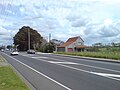
Riverhead, New Zealand (category Populated places around the Waitematā Harbour)
of the Waitematā Harbour in the north-west of Auckland, New Zealand. It is located on the northwestern shores of the Upper Waitematā Harbour, north-east...
19 KB (1,710 words) - 03:53, 4 August 2024

Maungakiekie-Tāmaki, Ōrākei, Ōtara-Papatoetoe, Puketāpapa, Upper Harbour, Waitākere Ranges, Waitematā and Whau. Rural townships and localities outside of the...
36 KB (445 words) - 19:46, 1 June 2024
Harbour Bridge on State Highway 18 provides a connection to West Auckland, across the Upper Waitematā Harbour. Three major estuaries of the Waitematā...
111 KB (10,008 words) - 03:34, 21 May 2024
The Auckland Harbour Bridge is an eight-lane motorway bridge over the Waitematā Harbour in Auckland, New Zealand. It joins St Marys Bay on the Auckland...
56 KB (6,127 words) - 16:15, 26 August 2024

Greenhithe, New Zealand (redirect from Upper Harbour Primary School)
North Shore of New Zealand. It is a peninsula surrounded by the Upper Waitematā Harbour, Lucas Creek and Oruamo or Hellyers Creek. The highest point in...
30 KB (2,885 words) - 21:37, 22 August 2024

(known traditionally as Hikurangi), south-western Kaipara and the Upper Waitematā Harbour. In the early 1700s the paramount chief of Te Kawerau ā Maki was...
11 KB (1,251 words) - 05:54, 13 April 2024

Albany, New Zealand (category Populated places around the Waitematā Harbour)
portage used by Tāmaki Māori, where waka could be taken between the Upper Waitematā Harbour and the Okura River/Hauraki Gulf. During the 1840s, early European...
49 KB (4,895 words) - 06:08, 28 June 2024

Hobsonville (category Populated places around the Waitematā Harbour)
west and the Upper Harbour Bridge in the east. Hobsonville is a peninsula between the Upper Waitematā Harbour and the central Waitematā Harbour. Hobsonville...
30 KB (2,945 words) - 00:05, 28 August 2024

Birkenhead, New Zealand (category Populated places around the Waitematā Harbour)
in northern New Zealand. It is located on the North Shore of the Waitematā Harbour, 4 kilometres (2.5 mi) northwest of the Auckland City Centre. The...
52 KB (5,346 words) - 19:45, 12 June 2024

election. Upper Harbour covers the northwestern reaches of Waitematā Harbour. It stretches from Massey, in West Auckland, through West Harbour and Hobsonville...
18 KB (633 words) - 01:45, 25 March 2024

developed between the Waitākere Ranges to the west and the upper reaches of the Waitematā Harbour to the east. It covers areas such as Glen Eden, Henderson...
94 KB (8,763 words) - 06:14, 12 May 2024
State Highway 18 (New Zealand) (redirect from Upper Harbour Motorway)
carriageway Upper Harbour Drive. The motorway heads south-west, crossing the upper reaches of the Waitematā Harbour over the Upper Harbour Bridge. At Squadron...
5 KB (262 words) - 19:59, 25 August 2024

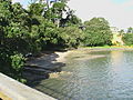
Boat Rock (category Waitematā Harbour)
the Waitematā Harbour of Auckland, New Zealand. Boat Rock is a vanishing island, which is submerged at high tide. The rock is a piece of Waitemata Group...
7 KB (512 words) - 06:39, 8 December 2023

portage was a path that connected the Lucas Creek, an arm of the Upper Waitematā Harbour, to the Okura River and Long Bay on the Hauraki Gulf. Some sources...
26 KB (2,609 words) - 23:27, 23 June 2024
Harbour in Auckland, New Zealand. Upper Harbour Bridge, an existing twin motorway bridge over the Waitemata Harbour in Auckland, New Zealand. The Twin...
1 KB (163 words) - 22:10, 18 August 2024
Beach Haven, New Zealand (category Populated places around the Waitematā Harbour)
located on the western North Shore, on the eastern shores of the Upper Waitematā Harbour. Southern Beach Haven is a suburban area known as Kauri Park. Prior...
20 KB (2,037 words) - 08:07, 28 May 2024
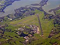
is a Royal New Zealand Air Force base located near the upper reaches of the Waitematā Harbour in Auckland, New Zealand. The base formerly comprised two...
7 KB (603 words) - 13:55, 21 August 2024

Hawke's Bay Tukituki River Catherine Wedd National Upper Harbour Auckland Upper Waitematā Harbour Cameron Brewer National Waikato Waikato Waikato River...
32 KB (1,680 words) - 02:38, 31 July 2024
densely settled as other areas of the North Shore, such as the Upper Waitematā Harbour eastern shores or the Devonport-Takapuna areas. The forests of...
36 KB (3,553 words) - 23:11, 6 June 2024

River valley was an important transport node between the Kaipara and Waitematā harbours, due to a portage called Te Tōangaroa, where waka could be hauled...
42 KB (4,657 words) - 03:24, 27 August 2024

Auckland (category Populated places around the Waitematā Harbour)
Bridge crossing the Waitematā Harbour west of the central business district. The Māngere Bridge and the Upper Harbour Bridge span the upper reaches of the...
170 KB (14,284 words) - 20:22, 22 August 2024

build new wharves or dredge the harbour channels, it was proposed that cargo ships moor out in the Waitematā Harbour channel and be unloaded into "lighters"...
28 KB (2,753 words) - 12:12, 11 June 2024