
coordinates) GPX (secondary coordinates) Watts Bar Lake is a reservoir on the Tennessee River created by Watts Bar Dam as part of the Tennessee Valley Authority...
6 KB (525 words) - 18:37, 15 February 2025

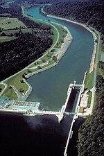
to Chattanooga. Watts Bar Dam is named for Watt Island, a sandbar located at the dam site prior to the dam's construction. Watts Bar Dam is located approximately...
10 KB (944 words) - 08:38, 15 February 2025

where it soon becomes an embayment of Watts Bar Lake several miles upstream of its mouth into the Emory. (Watts Bar Lake is a relatively deep reservoir and...
2 KB (117 words) - 22:39, 3 February 2025

981 at the 2010 census. The town is located along Watts Bar Lake, and Watts Bar Dam and the Watts Bar Nuclear Generating Station are nearby. Spring City...
17 KB (1,107 words) - 13:53, 9 August 2024

town at a headland of Watts Bar Lake, an impoundment of the Tennessee River formed by the Tennessee Valley Authority's Watts Bar Dam project. The mouth...
4 KB (357 words) - 08:32, 15 February 2025
Watts Bar may refer to: Watts Bar Nuclear Plant Watts Bar Dam Watts Bar Steam Plant Watts Bar Lake This disambiguation page lists articles about distinct...
141 bytes (53 words) - 05:41, 26 August 2019

state of Tennessee. Ten Mile is primarily a summer cottage community on Watts Bar Lake. It includes summer cottages, small locally owned stores and restaurants...
3 KB (314 words) - 16:31, 20 June 2024
Fort Loudoun Lake Watts Bar Dam impounds Watts Bar Lake Chickamauga Dam impounds Chickamauga Lake Nickajack Dam impounds Nickajack Lake Guntersville Dam...
4 KB (380 words) - 23:03, 12 November 2024
Melton Hill Dam (redirect from Melton Hill Lake)
the Roane-Loudon county line. Melton Hill's tailwaters are part of Watts Bar Lake, a main Tennessee River channel impoundment that extends across the...
7 KB (834 words) - 01:09, 6 January 2025

completed in 1940. The lake stretches from Watts Bar Dam at mile 529.9 (853 km) to Chickamauga Dam at mile 471.0 (758 km) making the lake 58.9 miles (94.8 km)...
6 KB (420 words) - 05:45, 15 February 2025

These confluences are now part of Watts Bar Lake, a reservoir created by the impoundment of the Tennessee by Watts Bar Dam several miles to the southwest...
21 KB (1,417 words) - 02:27, 28 August 2024

in Roane County, just outside Kingston, Tennessee, on the shore of Watts Bar Lake. It is operated by the Tennessee Valley Authority. The plant is known...
8 KB (699 words) - 18:33, 19 February 2024

following is a list of the 100 largest lakes of the United States by normal surface area. The top twenty lakes in size are as listed by the National Atlas...
16 KB (426 words) - 03:20, 9 June 2024

turning south before dropping off the plateau and emptying into the Watts Bar Lake impoundment of the Tennessee River. The Obed River flows eastwardly...
16 KB (1,529 words) - 07:29, 23 November 2024

impounds the 14,600-acre (5,900 ha) Fort Loudoun Lake and its tailwaters are part of Watts Bar Lake. The generating capacity of Fort Loudoun Dam is enhanced...
11 KB (1,233 words) - 06:52, 15 January 2025

western boundary. Watts Bar Dam is located along the river between Meigs and adjacent Rhea County. Above it is the manmade Watts Bar Lake, which spans the...
19 KB (1,810 words) - 03:08, 6 January 2025

before crossing Watts Bar Lake and entering Kingston, immediately passing by Fort Southwest Point. It then runs along the shores of the lake before entering...
12 KB (676 words) - 05:13, 18 January 2025

and picnic areas lining the shore. The lake is well known as a venue for rowing competitions. Watts Bar Lake, an impoundment of the Tennessee River which...
76 KB (7,667 words) - 22:01, 14 February 2025

Carolina; Lake Lanier in Georgia; Watts Bar Lake, in Tennessee; Lake Mead, Nevada; Lake Texoma on the border of Texas and Oklahoma, Lake Tawakoni, Lake Whitney...
29 KB (3,252 words) - 04:12, 10 February 2025

Philadelphia is situated along Sweetwater Creek, which empties into the Watts Bar Lake impoundment of the Tennessee River a few miles to the north. Philadelphia...
10 KB (771 words) - 15:52, 26 March 2024
Tennessee River with a few individuals dispersing into the headwaters of Watts Bar Lake below Fort Loudon Dam. Prior to the completion of the Tellico Dam in...
20 KB (2,578 words) - 17:32, 9 February 2025

Tennessee, creating Fort Loudoun Lake. The section of the river downstream from Fort Loudoun Dam is part of Watts Bar Lake. Knox County (northeast) Blount...
18 KB (1,680 words) - 21:09, 19 December 2024

Zone and Central Time Zone runs along Rockwood's western boundary. The Watts Bar Lake impoundment of the Tennessee River provides much of Rockwood's southern...
22 KB (1,837 words) - 00:57, 4 October 2024

Creek, which flows northeast for several miles before emptying into the Watts Bar Lake impoundment of the Tennessee River. The creek's drainage has created...
15 KB (1,221 words) - 17:10, 4 November 2024
Lake Isle of Innisfree Lough Gill Ireland Thetis Gulf Islands, British Columbia Canada Thibault Lake Huron, Ontario Canada Thief Neck Watts Bar Lake...
14 KB (63 words) - 01:57, 1 May 2024
north. Watts Bar Dam straddles the Tennessee River near Spring City. The section of the river upstream from the dam is part of Watts Bar Lake, and the...
26 KB (2,585 words) - 22:43, 6 February 2025
just downstream from Kingston. The rivers in Roane are mostly part of Watts Bar Lake. One notable valley is Suck-egg Hollow. Roane County straddles the geographical...
18 KB (1,520 words) - 07:21, 5 January 2025

the stream crosses into Roane County near Harriman. Backwaters of the Watts Bar Lake impoundment of the Tennessee River cause the water below Harriman to...
6 KB (467 words) - 23:01, 13 February 2025

Retrieved 13 March 2019. "Ruth Wear b. 17 Feb 1924 Tennessee d. 3 Sep 2001 Watts Bar Lake, Ten Mile, Tennessee: Smoky Mountain Ancestral Quest". smokykin.com...
12 KB (1,005 words) - 21:58, 29 January 2025
Lake Reelfoot Lake Tellico Lake Tims Ford Lake Watauga Lake Watts Bar Lake (largest lake in Tennessee) Wilbur Lake (Tennessee) Bear Lake Blind Lake Blue...
38 KB (2,832 words) - 23:06, 22 August 2024