
Wicklow Gap (Irish: Bearna Chill Mhantáin) is one of the highest Irish mountain passes served by an asphalted road. It is located in County Wicklow, Ireland...
4 KB (284 words) - 16:21, 15 January 2023

County Wicklow (/ˈwɪkloʊ/ WIK-loh; Irish: Contae Chill Mhantáin [ˈkɔn̪ˠt̪ˠeː ˌçiːl̠ʲ ˈwan̪ˠt̪ˠaːnʲ]) is a county in Ireland. The last of the traditional...
76 KB (6,802 words) - 13:51, 19 April 2024

metres (1,634 feet)) and the Wicklow Gap (478 metres (1,567 feet)) being the highest road passes in the country. The Wicklow Mountains are primarily composed...
54 KB (5,867 words) - 05:23, 1 April 2024

photography. Motor tourists may take the R756 road which passes through the Wicklow Gap. Another scenic driving route follows the historic Military Road designated...
8 KB (629 words) - 19:14, 14 June 2024

settlement of Glendalough. Sally Gap and the Glenmacnass Waterfall are to the north, to the west is Glendalough and the Wicklow Gap, and to the south is the Glenmalure...
4 KB (244 words) - 10:17, 25 August 2023
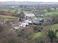
small church') is a village in west County Wicklow, Ireland. It is 15 km south of Naas on the Wicklow Gap road near its junction with the N81 road. It...
7 KB (521 words) - 15:48, 10 July 2024
Wicklow Mountains Wicklow GAA Wicklow Way Wicklow Gap The current parliamentary constituency bearing the county's name is: Wicklow (Dáil constituency)...
1 KB (224 words) - 11:18, 30 April 2023

R759 road (Ireland) (redirect from Sally Gap)
Sally Gap in the Wicklow Mountains, from the R755 near Roundwood in East Wicklow to the N81 in West Wicklow. The other route through the Wicklow Mountains...
2 KB (236 words) - 12:31, 20 August 2022

R756 road (Ireland) (category County Wicklow articles missing geocoordinate data)
Its entire 32 km (20 mi) length is within County Wicklow crossing east–west through the Wicklow Gap (Irish: Bearna Chill Mhantáin). From Dunlavin it heads...
3 KB (372 words) - 22:34, 4 July 2024

Glendalough (category Towns and villages in County Wicklow)
Dá Loch, meaning 'valley of two lakes') is a glacial valley in County Wicklow, Ireland, renowned for an Early Medieval monastic settlement founded in...
34 KB (3,759 words) - 17:23, 20 June 2024
Tonelagee (category Mountains and hills of County Wicklow)
that runs from the Sally Gap in the north, via Mullaghcleevaun, to Tonelagee. Tonelagee is the third highest peak in Wicklow after Lugnaquilla and Mullaghcleevaun...
10 KB (994 words) - 20:07, 8 October 2023

Thermopylae Fimmvörðuháls Barnesmore Gap Conor Pass Gap of Dunloe Healy Pass Mamore Gap Moll's Gap Wicklow Gap Col de l'Aiguillon Balmberg Pass Benkerjoch...
43 KB (3,236 words) - 10:30, 26 June 2024

Turlough Hill Power Station (category Buildings and structures in County Wicklow)
reservoir. Concerns about the impact of the scheme on the scenery at the Wicklow Gap led to ESB, whose chairman and chief executive at the time, Tom Murray...
14 KB (1,445 words) - 18:10, 23 November 2023

Saint Kevin's Way (category County Wicklow articles missing geocoordinate data)
path in County Wicklow, Ireland. It is 30 kilometres (19 miles) long and begins in the village of Hollywood, crosses the Wicklow Gap, and ends at the...
4 KB (303 words) - 18:09, 2 April 2024

the first of a seven-rider breakaway group to reach the summit of the Wicklow Gap mountain pass, claiming the Tour's first available mountains classification...
144 KB (12,086 words) - 22:49, 13 April 2024

Camaderry (category Mountains and hills of County Wicklow)
both lie across the deep Wicklow Gap from Tonelagee 817 metres (2,680 ft), which sits on the "central spine" of the Wicklow range. Between the north face...
8 KB (610 words) - 18:22, 29 September 2022
(2000) Reign of Fire (2002) - entire movie, includes scenes shot at Wicklow Gap and Poolbeg Generating Station Ella Enchanted (2004) King Arthur (2004)...
53 KB (4,643 words) - 11:02, 8 March 2024

Turlough Hill (category Mountains and hills of County Wicklow)
easily reached via the tarmac access road that begins at the top of the Wicklow Gap. It is also possible to reach the summit from Glendalough or from the...
7 KB (622 words) - 09:58, 1 July 2022
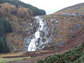
Glenmacnass Waterfall (category Tourist attractions in County Wicklow)
Wicklow Mountains, and the entire Glenmacnass Valley can be accessed by the R115 road (also called the Military Road), which connects the Sally Gap to...
6 KB (583 words) - 23:45, 1 July 2024
Ireland's first ever wearer of the yellow jersey in the Tour de France, Wicklow Gap – a climb ridden by the competitors in the 1998 Tour de France - and...
2 KB (221 words) - 22:40, 11 April 2022

Wicklow Head (Irish: Ceann Chill Mhantáin) is a headland near the southeast edge of the town of Wicklow in County Wicklow, approximately 3 kilometres...
4 KB (370 words) - 21:09, 14 May 2022

Avondale Forest (redirect from Avondale, County Wicklow)
Avondale Forest is a wooded estate in County Wicklow, Ireland, on the west bank of the River Avonmore. It contains the home of Charles Stewart Parnell...
4 KB (283 words) - 20:39, 3 April 2024

Glen of Imaal (category Valleys of County Wicklow)
or /ˈiːmɑːl/; Irish: Gleann Uí Mháil) is a remote glen in the western Wicklow Mountains in Ireland. It is ringed by the Lugnaquilla massif and its foothills...
17 KB (1,595 words) - 13:03, 6 February 2024

Croghan Mountain to the north by the "Wicklow Gap", not to be confused with the Wicklow Gap in County Wicklow. Except for the southeastern face (see...
2 KB (101 words) - 07:05, 23 December 2023

Finbarr's Pilgrim Path, Cork (Drimoleague to Gougane Barra) St. Kevin's Way, Wicklow (Hollywood to Glendalough) Tochar Phádraig, Mayo (Ballintubber Abbey to...
17 KB (1,464 words) - 08:42, 30 December 2020
September 2011 Original Archive Wicklow €120,000, then €150,000 A remote tiny 100-year-old ex-council cottage in the Wicklow Gap is damp and mouldy and is no...
43 KB (551 words) - 23:28, 8 January 2024

The Wicklow Way (Irish: Slí Cualann Nua, meaning 'New Cuala Way') is a 131-kilometre (81-mile) long-distance trail that crosses the Wicklow Mountains...
46 KB (5,447 words) - 09:30, 22 May 2023

R115 road (Ireland) (category Roads in County Wicklow)
the R755 and the 'Wicklow Gap' road, the R756. The Military Road continues south past Glenmalure to Aghavannagh in south County Wicklow, but is designated...
8 KB (707 words) - 18:10, 17 November 2023
Bray make it a double". Wicklow People. 5 October 2015. Retrieved 25 October 2023. "Wicklow SHC final: Bray bridge 64-year gap". Hogan Stand. 6 October...
25 KB (1,136 words) - 02:04, 10 January 2024

Mullaghcleevaun (category Mountains and hills of County Wicklow)
is in the central sector of the Wicklow Mountains range, in Wicklow, Ireland; it is the 2nd highest peak in Wicklow after Lugnaquilla. Mullaghcleevaun...
11 KB (964 words) - 16:06, 10 January 2022