
The A39 is an A road in south west England. It runs south-west from Bath in Somerset through Wells, Glastonbury, Street and Bridgwater. It then follows...
8 KB (800 words) - 17:44, 26 January 2023
a road in Victoria designated A39/B340 A39 motorway (France), a road connecting Dijon with Dole and Bourg en Bresse A 39 motorway (Germany), a road connecting...
549 bytes (110 words) - 11:09, 1 September 2018

Westward Ho! is a seaside village near Bideford in Devon, England. The A39 road provides access from the towns of Barnstaple, Bideford, and Bude. It lies...
12 KB (1,314 words) - 11:14, 19 August 2024

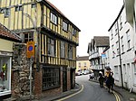
Wadebridge (section Eddystone Road)
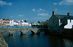
walkers, cyclists and horse riders. The town used to be a road traffic bottleneck on the A39 road until it was bypassed in 1991, and the main shopping street...
29 KB (3,174 words) - 10:58, 13 August 2024

is a Grade II listed folly located at Beechbarrow on Pen Hill, by the A39 road to Wells, Somerset, England. It was designed and sculpted by a former Italian...
37 KB (3,064 words) - 02:21, 30 August 2024
of the A39 road in England Atlantic Highway (United States), an auto trail replaced by U.S. Route 1 Atlantic Ocean Road, also the Atlantic Road, in Norway...
286 bytes (71 words) - 16:01, 9 November 2014

couple who ran the Perch Garage at the eponymous Winnard's Perch on the A39 road Atlantic Highway from Wadebridge. The couple had owned the garage and car...
16 KB (1,517 words) - 14:44, 10 May 2024

cliff-face to the south, and steep grassy slopes to the north. The B3135 road runs along the bottom of the gorge. The area is underlain by Black Rock slate...
33 KB (3,168 words) - 13:35, 28 July 2024

Torridge district of Devon, England. The village is accessible via the A39 road, 2 miles (3 km) from the village. Woolfardisworthy, jointly with a few...
4 KB (288 words) - 11:48, 11 July 2024
Rail Mendip Way Monarch's Way National Cycle Route 24 A37 road A39 road A368 road A371 road Councils Bath and North East Somerset North Somerset Somerset...
17 KB (1,832 words) - 17:30, 11 August 2024

the Tamar at Plymouth via the Tamar Bridge and the town of Saltash, the A39 road (Atlantic Highway) from Barnstaple, passing through North Cornwall to end...
143 KB (13,589 words) - 22:16, 7 August 2024

Porlock Hill (category Roads in Somerset)
Hill is a road west of Porlock, Somerset. It is part of the A39, connecting Porlock to Lynmouth and Barnstaple in Devon and is the steepest A-road in the...
7 KB (719 words) - 13:45, 28 August 2024

east of Newquay. It lies between the A30 dual carriageway trunk road and the A39 road through St Columb Major. The hamlet derives its name from a dolmen...
2 KB (150 words) - 16:23, 6 December 2022
at Davidstow and there is a small industrial estate at Highfield. The A39 road (dubbed 'Atlantic Highway') passes through the town centre: a bypass has...
19 KB (1,999 words) - 11:00, 18 June 2024

North Devon Link Road, and enables relatively fast access to the Atlantic Highway, relieving pressure on the northern section of the A39 and A358. This...
11 KB (1,022 words) - 10:00, 4 June 2024
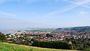
Wells, Somerset (redirect from Balch Road)
motorway connections are at junction 23 on the M5 via the A39 and at junction 1 of the M32 via the A39 and A37. Wells is served by First West of England bus...
82 KB (7,871 words) - 23:08, 25 August 2024

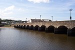
furthest downstream bridge on the river until 1987, when the Torridge A39 Road Bridge was built a mile or so further downstream at Northam. The river...
16 KB (1,931 words) - 03:30, 12 July 2024

Falmouth, Cornwall (section Road)
Knox-Johnston and Dame Ellen MacArthur. Falmouth is a terminus of the A39 road, connecting to Bath, Somerset some 180 miles (290 km) distant although...
47 KB (5,116 words) - 12:37, 22 August 2024
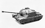
Tortoise heavy assault tank (redirect from A39 Tortoise)
The Tortoise heavy assault tank (A39) was a British heavy assault gun design developed during the Second World War, but never put into mass production...
11 KB (1,160 words) - 03:35, 25 August 2024
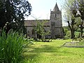
small village and civil parish close to the River Avon and situated on the A39 road in the Bath and North East Somerset unitary authority, Somerset, England...
7 KB (638 words) - 08:59, 11 August 2024

(Whalesborough Lock) SS213043 Restored A39 road bridge 50°48′20″N 4°32′05″W / 50.80545°N 4.53474°W / 50.80545; -4.53474 (A39 road bridge) SS215037 Hele Bridge...
23 KB (2,292 words) - 13:13, 23 August 2024
Bowdens Park on Draycott Road to a new larger site. Cheddar Cricket Club was formed in the late 19th century and moved to Sharpham Road Playing Fields in 1964...
63 KB (6,009 words) - 14:07, 29 August 2024

Rail Mendip Way Monarch's Way National Cycle Route 24 A37 road A39 road A368 road A371 road Councils Bath and North East Somerset North Somerset Somerset...
55 KB (6,575 words) - 04:18, 16 August 2024

Collamoor Head is a junction on the A39 road where it is met from the west by the B3263 road in Cornwall, England. It is in the parish of Otterham. Cornwall...
1 KB (56 words) - 15:18, 24 March 2020

Rail Mendip Way Monarch's Way National Cycle Route 24 A37 road A39 road A368 road A371 road Councils Bath and North East Somerset North Somerset Somerset...
2 KB (208 words) - 06:41, 25 July 2024

close to the route of the Fosse Way and is now on the route of the modern A39 road which runs from Bath to Cornwall, and the A361. Glastonbury and Street...
40 KB (4,342 words) - 13:20, 17 August 2024

stands above the level crossing. This sees little road traffic as most crosses the railway on the A39 road bridge that stands just beyond the end of the passing...
56 KB (7,453 words) - 16:31, 21 March 2024
and Poughill, and north of Widemouth Bay, located along the A3073 road off the A39. Bude is twinned with Ergué-Gabéric in Brittany, France. Bude's coast...
32 KB (3,210 words) - 19:28, 2 April 2024
William, son of King Charles III - Rain-Charm for the Duchy. Local rail and road routes follow the river from Barnstaple through the centre of the county...
11 KB (933 words) - 06:52, 13 July 2024
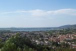
south—means that transport links are limited. Minehead is located on the A39 road, and is 28 miles (45 km) north-west of the M5 motorway at junction 24....
50 KB (5,245 words) - 04:42, 5 July 2024